Edwards-Kinney County Line, Field Notes & Correspondence, 1933
K-7-83
-
Map/Doc
62881
-
Collection
General Map Collection
-
Object Dates
1931/9/24 (Creation Date)
-
People and Organizations
J.H. Walker (GLO Commissioner)
-
Counties
Edwards Kinney
-
Subjects
County Boundaries
-
Height x Width
11.2 x 8.7 inches
28.4 x 22.1 cm
-
Comments
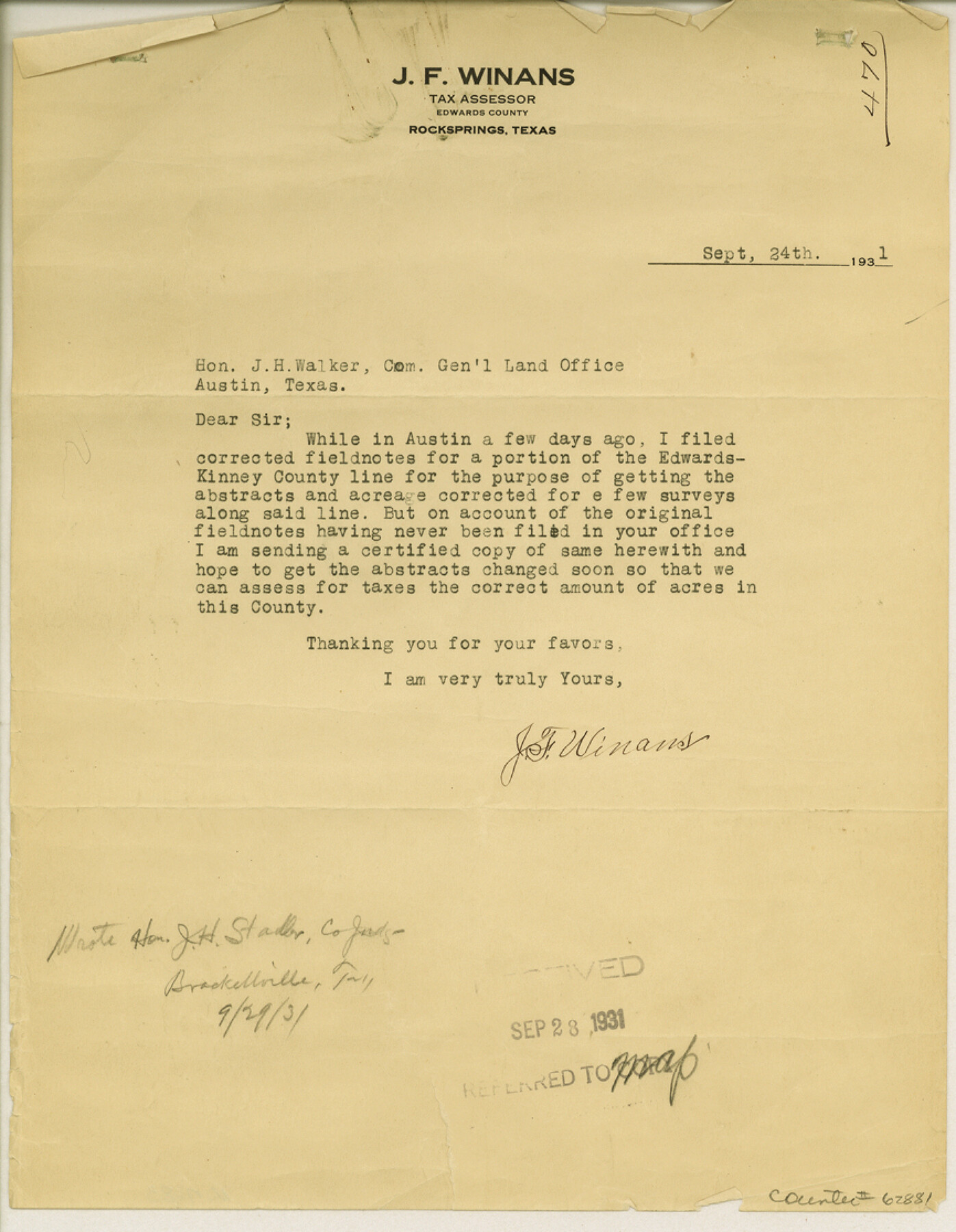
From J. F. Winans, Tax Assessor of Edwards County to Commissioner J. H. Walker.
Received September 28, 1931.
Part of: General Map Collection
Map of Hays County

Print $20.00
- Digital $50.00
Map of Hays County
1880
Size 26.0 x 21.8 inches
Map/Doc 4562
Flight Mission No. DQN-2K, Frame 147, Calhoun County

Print $20.00
- Digital $50.00
Flight Mission No. DQN-2K, Frame 147, Calhoun County
1953
Size 19.0 x 22.6 inches
Map/Doc 84316
Flight Mission No. DIX-6P, Frame 200, Aransas County

Print $20.00
- Digital $50.00
Flight Mission No. DIX-6P, Frame 200, Aransas County
1956
Size 19.0 x 22.7 inches
Map/Doc 83862
Travis County Working Sketch 49

Print $20.00
- Digital $50.00
Travis County Working Sketch 49
1984
Size 33.9 x 37.2 inches
Map/Doc 69433
Matagorda County Rolled Sketch 37A

Print $40.00
- Digital $50.00
Matagorda County Rolled Sketch 37A
Size 48.7 x 41.1 inches
Map/Doc 10195
Burleson County Working Sketch 5

Print $20.00
- Digital $50.00
Burleson County Working Sketch 5
1980
Size 34.8 x 27.6 inches
Map/Doc 67724
Jack County Boundary File 3a

Print $50.00
- Digital $50.00
Jack County Boundary File 3a
Size 8.7 x 7.4 inches
Map/Doc 55413
Wood County Sketch File 7

Print $17.00
- Digital $50.00
Wood County Sketch File 7
1848
Size 11.9 x 7.7 inches
Map/Doc 40645
Carta Etnografica

Print $20.00
- Digital $50.00
Carta Etnografica
1897
Size 26.2 x 34.1 inches
Map/Doc 96798
Amplissimae Regionis Mississipi seu Provinciae Ludovicianae a R.P. Ludovico Hennepin Francisc Miss in America Septentrionali Anno 1687. Detectae, Nunc Gallorum Coloniis et Actionum Negotiis Toto Orbe Celeberrimae

Print $20.00
- Digital $50.00
Amplissimae Regionis Mississipi seu Provinciae Ludovicianae a R.P. Ludovico Hennepin Francisc Miss in America Septentrionali Anno 1687. Detectae, Nunc Gallorum Coloniis et Actionum Negotiis Toto Orbe Celeberrimae
1720
Size 20.7 x 24.2 inches
Map/Doc 97516
Haskell County

Print $20.00
- Digital $50.00
Haskell County
1888
Size 38.5 x 37.1 inches
Map/Doc 4700
Schleicher County Working Sketch 9

Print $20.00
- Digital $50.00
Schleicher County Working Sketch 9
1923
Size 12.4 x 11.8 inches
Map/Doc 63811
You may also like
Henderson County Rolled Sketch 11

Print $20.00
- Digital $50.00
Henderson County Rolled Sketch 11
1915
Size 29.1 x 42.4 inches
Map/Doc 75948
General Highway Map, Tyler County, Texas

Print $20.00
General Highway Map, Tyler County, Texas
1940
Size 24.8 x 18.1 inches
Map/Doc 79264
Flight Mission No. DCL-7C, Frame 54, Kenedy County

Print $20.00
- Digital $50.00
Flight Mission No. DCL-7C, Frame 54, Kenedy County
1943
Size 15.3 x 15.3 inches
Map/Doc 86042
Jackson County

Print $20.00
- Digital $50.00
Jackson County
1896
Size 24.8 x 21.0 inches
Map/Doc 3710
Hockley County Sketch, Mineral Application Number 38245

Print $20.00
- Digital $50.00
Hockley County Sketch, Mineral Application Number 38245
Size 27.2 x 10.8 inches
Map/Doc 91093
Lipscomb County Rolled Sketch 8

Print $40.00
- Digital $50.00
Lipscomb County Rolled Sketch 8
1940
Size 59.2 x 28.5 inches
Map/Doc 9453
A Topographical Map of the Government Tract Adjoining the City of Austin

Print $20.00
- Digital $50.00
A Topographical Map of the Government Tract Adjoining the City of Austin
1840
Size 41.9 x 37.4 inches
Map/Doc 4842
Duval County Sketch File 45b

Print $40.00
- Digital $50.00
Duval County Sketch File 45b
1936
Size 26.0 x 18.1 inches
Map/Doc 11399
Lavaca County Sketch File 5

Print $4.00
- Digital $50.00
Lavaca County Sketch File 5
1858
Size 8.2 x 10.1 inches
Map/Doc 29639
Portion of Scurry County

Print $20.00
- Digital $50.00
Portion of Scurry County
1882
Size 35.1 x 25.3 inches
Map/Doc 92923
King County Working Sketch 7

Print $20.00
- Digital $50.00
King County Working Sketch 7
1952
Size 34.7 x 24.9 inches
Map/Doc 70171
Edwards County Working Sketch 12

Print $20.00
- Digital $50.00
Edwards County Working Sketch 12
1922
Size 26.2 x 26.7 inches
Map/Doc 68888