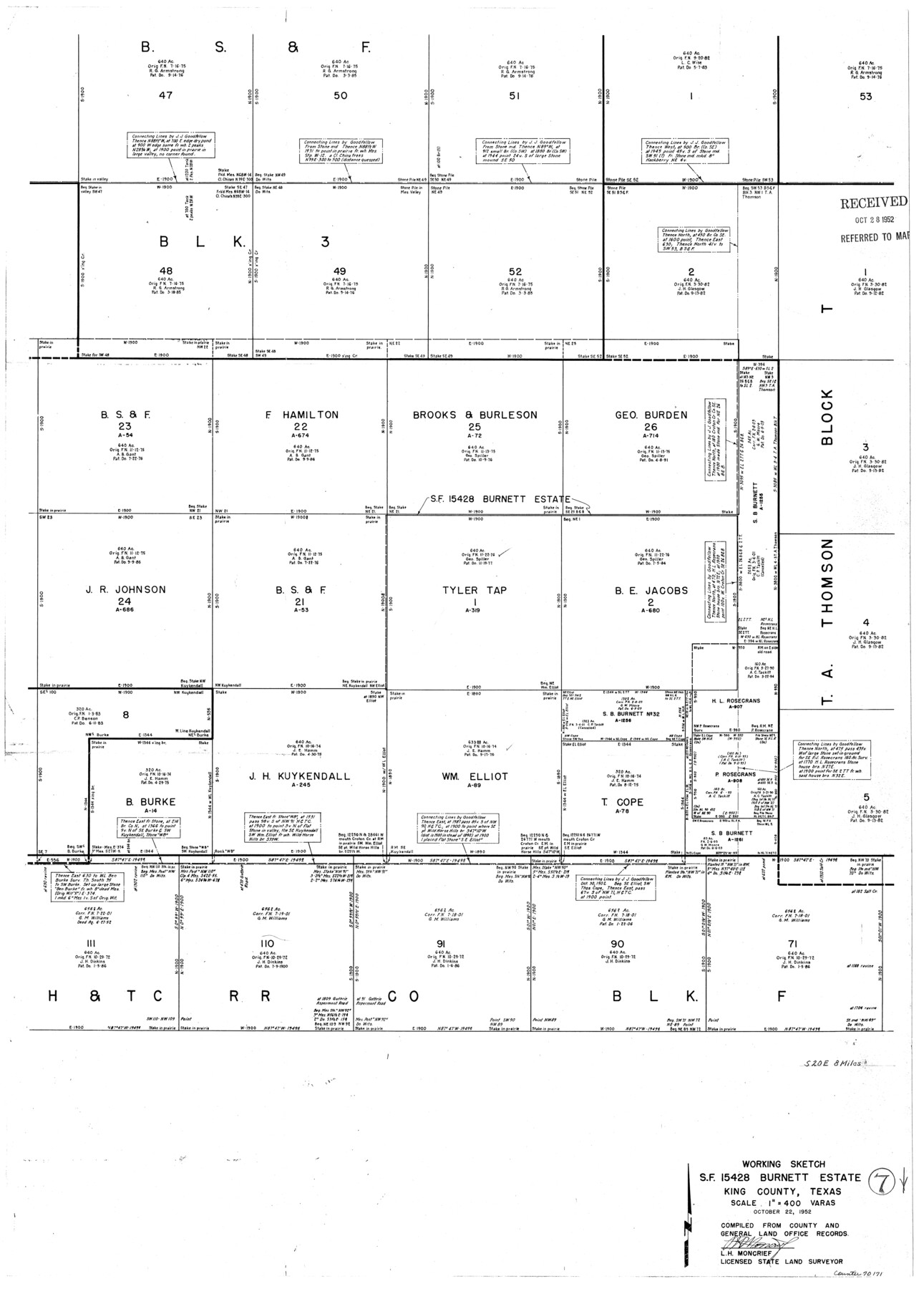
King County Working Sketch 7
-
Map/Doc
70171
-
Collection
General Map Collection
-
Object Dates
10/22/1952 (Creation Date)
-
People and Organizations
L.H. Moncrief (Surveyor/Engineer)
-
Counties
King
-
Subjects
Surveying Working Sketch
-
Height x Width
34.7 x 24.9 inches
88.1 x 63.3 cm
-
Scale
1" = 400 varas
Part of: General Map Collection
Flight Mission No. CRC-3R, Frame 27, Chambers County

Print $20.00
- Digital $50.00
Flight Mission No. CRC-3R, Frame 27, Chambers County
1956
Size 18.7 x 22.3 inches
Map/Doc 84801
Presidio County Sketch File 47

Print $16.00
- Digital $50.00
Presidio County Sketch File 47
1918
Size 7.2 x 8.1 inches
Map/Doc 34574
Yoakum County Sketch File 3

Print $54.00
- Digital $50.00
Yoakum County Sketch File 3
1892
Size 14.2 x 8.8 inches
Map/Doc 40705
The Inca, An Empire and its Ancestors

The Inca, An Empire and its Ancestors
Size 31.2 x 20.4 inches
Map/Doc 95936
San Jacinto County Sketch File 18

Print $20.00
San Jacinto County Sketch File 18
1934
Size 43.6 x 18.1 inches
Map/Doc 10599
Northern Part of Laguna Madre

Print $20.00
- Digital $50.00
Northern Part of Laguna Madre
1988
Size 45.1 x 36.4 inches
Map/Doc 73531
Pecos County Working Sketch 9

Print $20.00
- Digital $50.00
Pecos County Working Sketch 9
1907
Size 32.4 x 26.7 inches
Map/Doc 71479
Limestone County Working Sketch 28

Print $20.00
- Digital $50.00
Limestone County Working Sketch 28
2008
Size 30.2 x 29.1 inches
Map/Doc 88848
Hardin County Sketch File 3

Print $4.00
- Digital $50.00
Hardin County Sketch File 3
Size 7.7 x 4.6 inches
Map/Doc 25086
Travis County Rolled Sketch 35

Print $20.00
- Digital $50.00
Travis County Rolled Sketch 35
1949
Size 22.8 x 24.6 inches
Map/Doc 8036
Harris County Working Sketch 35

Print $20.00
- Digital $50.00
Harris County Working Sketch 35
1938
Size 28.8 x 25.2 inches
Map/Doc 65927
Tyler County Sketch File 6-2

Print $20.00
- Digital $50.00
Tyler County Sketch File 6-2
1861
Size 16.8 x 22.5 inches
Map/Doc 12498
You may also like
Travis County Sketch File 4

Print $9.00
- Digital $50.00
Travis County Sketch File 4
1853
Size 13.1 x 8.2 inches
Map/Doc 38275
Stonewall County Rolled Sketch 9

Print $20.00
- Digital $50.00
Stonewall County Rolled Sketch 9
Size 35.8 x 30.8 inches
Map/Doc 7865
[Section 1, Block 12, H. & G. N. RR. Co.]
![91651, [Section 1, Block 12, H. & G. N. RR. Co.], Twichell Survey Records](https://historictexasmaps.com/wmedia_w700/maps/91651-1.tif.jpg)
Print $3.00
- Digital $50.00
[Section 1, Block 12, H. & G. N. RR. Co.]
Size 12.9 x 9.6 inches
Map/Doc 91651
Crockett County Working Sketch 39

Print $20.00
- Digital $50.00
Crockett County Working Sketch 39
1928
Size 14.7 x 22.2 inches
Map/Doc 68372
Montgomery County Working Sketch 53

Print $20.00
- Digital $50.00
Montgomery County Working Sketch 53
1961
Size 28.2 x 30.2 inches
Map/Doc 71160
Anderson County Working Sketch 24

Print $20.00
- Digital $50.00
Anderson County Working Sketch 24
1917
Size 16.6 x 15.3 inches
Map/Doc 67024
Brewster County Rolled Sketch 22F

Print $20.00
- Digital $50.00
Brewster County Rolled Sketch 22F
1909
Size 19.0 x 25.4 inches
Map/Doc 5206
Map of the Missouri Pacific Central Branch U.P.R.R. St. Louis, Iron Mountain & Southern International & Great Northern and Texas and Pacific Railways

Print $20.00
- Digital $50.00
Map of the Missouri Pacific Central Branch U.P.R.R. St. Louis, Iron Mountain & Southern International & Great Northern and Texas and Pacific Railways
1890
Size 28.7 x 24.4 inches
Map/Doc 97505
Travis County Appraisal District Plat Map 3_1100

Print $20.00
- Digital $50.00
Travis County Appraisal District Plat Map 3_1100
Size 21.5 x 26.4 inches
Map/Doc 94212
San Patricio County Rolled Sketch 46E

Print $20.00
- Digital $50.00
San Patricio County Rolled Sketch 46E
1983
Size 17.4 x 46.3 inches
Map/Doc 8376

Howard County Sketch File 15

Print $6.00
- Digital $50.00
Howard County Sketch File 15
Size 11.2 x 8.8 inches
Map/Doc 26875