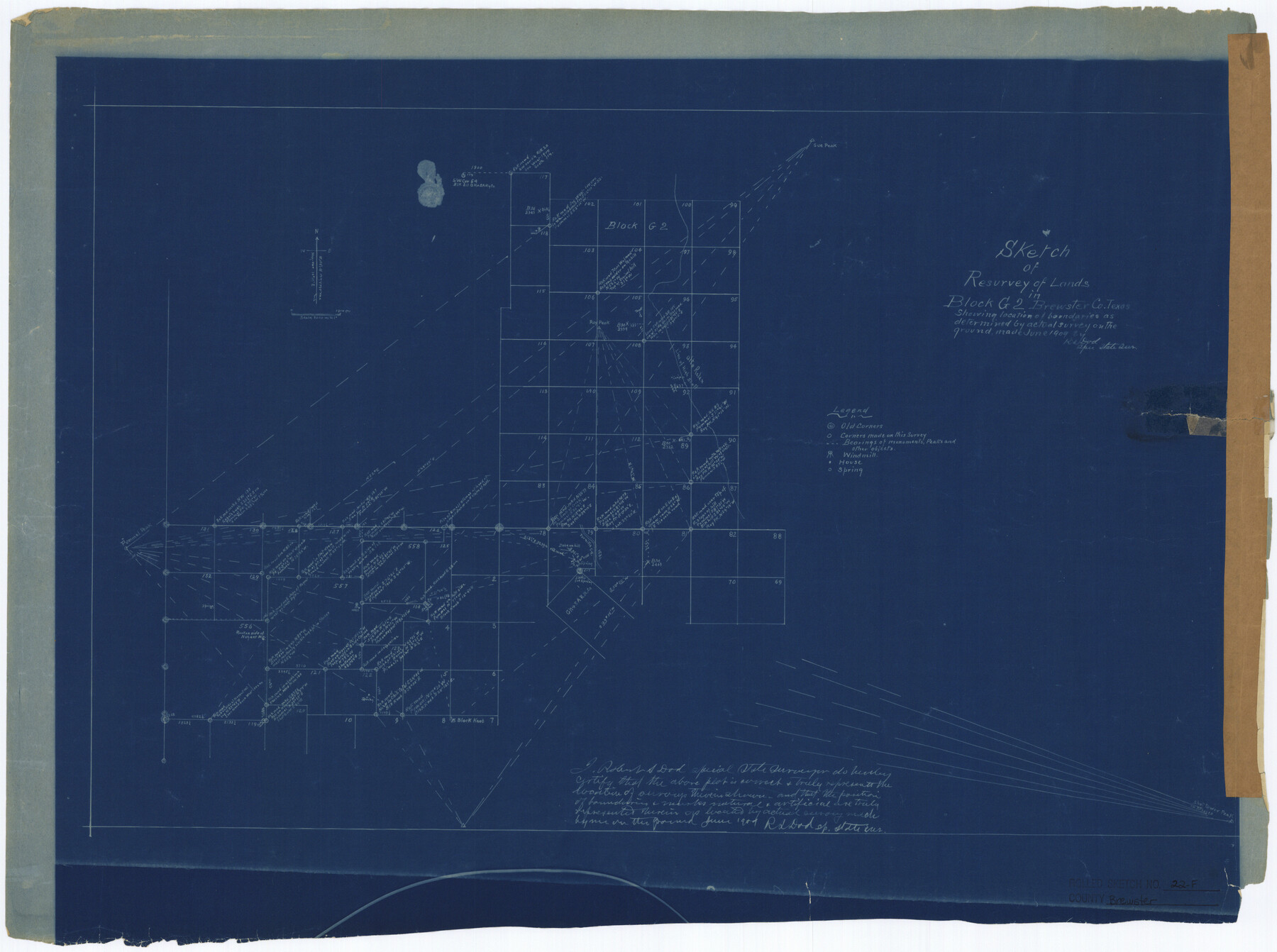
Brewster County Rolled Sketch 22F
Sketch of resurvey of lands in Block G2, Brewster Co., Texas, showing location of boundaries as determined by actual survey on the ground
-
Map/Doc
5206
-
Collection
General Map Collection
-
Object Dates
1909 (Creation Date)
-
People and Organizations
R.S. Dod (Surveyor/Engineer)
-
Counties
Brewster
-
Subjects
Surveying Rolled Sketch
-
Height x Width
19.0 x 25.4 inches
48.3 x 64.5 cm
-
Medium
blueprint/diazo
-
Comments
See Brewster County Rolled Sketch 125 (43141) for surveyor’s report.
Related maps
Brewster County Rolled Sketch 125

Print $179.00
- Digital $50.00
Brewster County Rolled Sketch 125
1889
Map/Doc 43141
Part of: General Map Collection
San Augustine County Working Sketch 5

Print $20.00
- Digital $50.00
San Augustine County Working Sketch 5
1935
Size 39.0 x 37.4 inches
Map/Doc 63692
Uvalde County Sketch File 16a

Print $6.00
- Digital $50.00
Uvalde County Sketch File 16a
Size 11.0 x 13.4 inches
Map/Doc 38995
Liberty County Sketch File 36

Print $2.00
- Digital $50.00
Liberty County Sketch File 36
Size 9.4 x 9.0 inches
Map/Doc 29973
Edwards County Boundary File 27c

Print $29.00
- Digital $50.00
Edwards County Boundary File 27c
Size 12.8 x 8.1 inches
Map/Doc 52896
Plat of Resurvey of Sections 5, 7 and 8, T. 5S., R. 14W. Indian Meridian, Oklahoma

Print $4.00
- Digital $50.00
Plat of Resurvey of Sections 5, 7 and 8, T. 5S., R. 14W. Indian Meridian, Oklahoma
1917
Size 18.5 x 22.6 inches
Map/Doc 75140
Harrison County Rolled Sketch 6

Print $20.00
- Digital $50.00
Harrison County Rolled Sketch 6
1952
Size 23.8 x 24.6 inches
Map/Doc 6151
Newton County Rolled Sketch 8

Print $20.00
- Digital $50.00
Newton County Rolled Sketch 8
1945
Size 21.5 x 28.7 inches
Map/Doc 6844
Flight Mission No. DAG-24K, Frame 154, Matagorda County

Print $20.00
- Digital $50.00
Flight Mission No. DAG-24K, Frame 154, Matagorda County
1953
Size 18.5 x 22.2 inches
Map/Doc 86568
Parker County

Print $20.00
- Digital $50.00
Parker County
1942
Size 46.7 x 37.9 inches
Map/Doc 73258
Harris County Boundary File 40

Print $8.00
- Digital $50.00
Harris County Boundary File 40
Size 14.2 x 8.7 inches
Map/Doc 54370
Brewster County Rolled Sketch 86

Print $20.00
- Digital $50.00
Brewster County Rolled Sketch 86
1940
Size 16.1 x 26.4 inches
Map/Doc 5247
Wharton County Working Sketch 14

Print $20.00
- Digital $50.00
Wharton County Working Sketch 14
1961
Size 26.5 x 24.9 inches
Map/Doc 72478
You may also like
Flight Mission No. CGN-3P, Frame 23, San Patricio County

Print $20.00
- Digital $50.00
Flight Mission No. CGN-3P, Frame 23, San Patricio County
1956
Size 18.6 x 22.2 inches
Map/Doc 86981
Potter County Sketch File 10

Print $40.00
- Digital $50.00
Potter County Sketch File 10
Size 58.9 x 37.7 inches
Map/Doc 10576
Trinity County Sketch File 43

Print $40.00
- Digital $50.00
Trinity County Sketch File 43
1854
Size 19.2 x 23.6 inches
Map/Doc 12495
Young County Working Sketch 6

Print $20.00
- Digital $50.00
Young County Working Sketch 6
1919
Size 12.2 x 11.9 inches
Map/Doc 62029
Mason County Boundary File 1

Print $2.00
- Digital $50.00
Mason County Boundary File 1
Size 12.7 x 8.2 inches
Map/Doc 56829
Rusk County Working Sketch 1

Print $20.00
- Digital $50.00
Rusk County Working Sketch 1
Size 14.2 x 23.1 inches
Map/Doc 63636
[PSL Block B-19]
![93127, [PSL Block B-19], Twichell Survey Records](https://historictexasmaps.com/wmedia_w700/maps/93127-1.tif.jpg)
Print $40.00
- Digital $50.00
[PSL Block B-19]
Size 49.1 x 45.5 inches
Map/Doc 93127
Kendall County

Print $20.00
- Digital $50.00
Kendall County
1946
Size 40.8 x 35.4 inches
Map/Doc 73203
Pecos County Sketch

Print $20.00
- Digital $50.00
Pecos County Sketch
Size 34.2 x 23.2 inches
Map/Doc 92915
Brown County Sketch File 20

Print $10.00
- Digital $50.00
Brown County Sketch File 20
Size 6.6 x 8.3 inches
Map/Doc 16620
Map showing the resurvey of Block M24 T. C. R.R. Co. in Hutchinson County, Texas

Print $20.00
- Digital $50.00
Map showing the resurvey of Block M24 T. C. R.R. Co. in Hutchinson County, Texas
Size 28.8 x 30.8 inches
Map/Doc 76178
General Highway Map. Detail of Cities and Towns in Harris County, Texas. City Map [of] Houston, Pasadena, West University Place, Bellaire, Galena Park, Jacinto City, South Houston, South Side Place, Deer Park, and vicinity, Harris County, Texas
![79507, General Highway Map. Detail of Cities and Towns in Harris County, Texas. City Map [of] Houston, Pasadena, West University Place, Bellaire, Galena Park, Jacinto City, South Houston, South Side Place, Deer Park, and vicinity, Harris County, Texas, Texas State Library and Archives](https://historictexasmaps.com/wmedia_w700/maps/79507.tif.jpg)
Print $20.00
General Highway Map. Detail of Cities and Towns in Harris County, Texas. City Map [of] Houston, Pasadena, West University Place, Bellaire, Galena Park, Jacinto City, South Houston, South Side Place, Deer Park, and vicinity, Harris County, Texas
1961
Size 18.1 x 24.7 inches
Map/Doc 79507