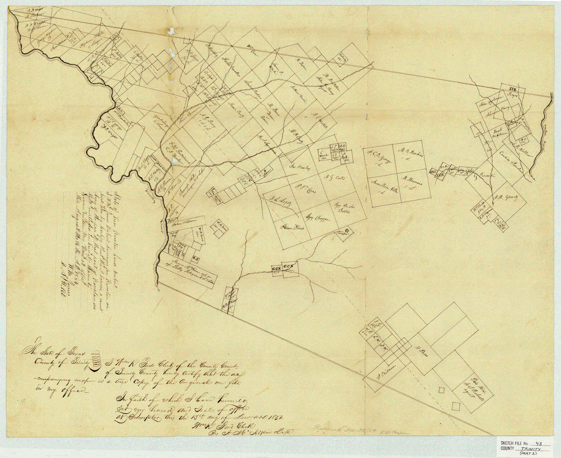
Trinity County Sketch File 43
[Two sketches of large areas in Trinity and Polk Counties]
-
Map/Doc
12495
-
Collection
General Map Collection
-
Object Dates
1854-1855 (Creation Date)
-
People and Organizations
John E. Baumgarthen (Surveyor/Engineer)
W.M. James (Surveyor/Engineer)
-
Counties
Trinity Polk
-
Subjects
Surveying Sketch File
-
Height x Width
19.2 x 23.6 inches
48.8 x 59.9 cm
-
Medium
paper, manuscript
-
Features
Kickapoo Creek
Big White Rock Creek
Caney Creek
Lexington
Road to Lexington
Prairie Creek
White Rock Creek
Moscow
Bear Creek
Salt Creek
Brushy Creek
Hal [?] Creek
Rocky Creek
Sebastopool
Neches River
Alabama Creek
Sandy Creek
Hackberry Creek
Little Cedar Creek
Cedar Creek
Elm Creek
East White Creek
Big White Creek
Road to Crockett
Molly Creek
Big Piney Creek
Kochens Creek
Trinity River
Part of: General Map Collection
Grayson County Boundary File 35

Print $42.00
- Digital $50.00
Grayson County Boundary File 35
Size 9.3 x 7.9 inches
Map/Doc 53961
Brooks County Rolled Sketch 14

Print $20.00
- Digital $50.00
Brooks County Rolled Sketch 14
Size 28.4 x 32.8 inches
Map/Doc 5339
Map of North America engraved to illustrate Mitchell's school and family geography

Print $20.00
- Digital $50.00
Map of North America engraved to illustrate Mitchell's school and family geography
1839
Size 11.8 x 9.5 inches
Map/Doc 93493
Burnet County Boundary File 6

Print $14.00
- Digital $50.00
Burnet County Boundary File 6
Size 14.1 x 8.6 inches
Map/Doc 50886
Presidio County Rolled Sketch 91

Print $20.00
- Digital $50.00
Presidio County Rolled Sketch 91
Size 15.1 x 29.4 inches
Map/Doc 7376
Haskell County Boundary File 1a

Print $40.00
- Digital $50.00
Haskell County Boundary File 1a
Size 34.9 x 38.3 inches
Map/Doc 54536
Austin County Sketch File 4

Print $8.00
- Digital $50.00
Austin County Sketch File 4
1881
Size 12.9 x 8.3 inches
Map/Doc 13857
Marion County Rolled Sketch JRC

Print $20.00
- Digital $50.00
Marion County Rolled Sketch JRC
1953
Size 19.4 x 20.5 inches
Map/Doc 6662
Presidio County Rolled Sketch 69

Print $20.00
- Digital $50.00
Presidio County Rolled Sketch 69
1927
Size 36.5 x 14.1 inches
Map/Doc 7359
Shelby County Working Sketch 27

Print $20.00
- Digital $50.00
Shelby County Working Sketch 27
1995
Size 32.8 x 39.9 inches
Map/Doc 63881
Zapata County Working Sketch 15

Print $20.00
- Digital $50.00
Zapata County Working Sketch 15
1969
Size 38.2 x 38.7 inches
Map/Doc 62066
Clay County Working Sketch 2

Print $20.00
- Digital $50.00
Clay County Working Sketch 2
1907
Size 26.5 x 16.2 inches
Map/Doc 68025
You may also like
Packery Channel

Print $20.00
- Digital $50.00
Packery Channel
1937
Size 23.8 x 22.4 inches
Map/Doc 3008
Montague County Rolled Sketch 7

Print $20.00
- Digital $50.00
Montague County Rolled Sketch 7
1964
Size 17.8 x 22.9 inches
Map/Doc 6791
Flight Mission No. DIX-6P, Frame 135, Aransas County

Print $20.00
- Digital $50.00
Flight Mission No. DIX-6P, Frame 135, Aransas County
1956
Size 19.5 x 23.0 inches
Map/Doc 83841
Liberty County Sketch File 12

Print $6.00
- Digital $50.00
Liberty County Sketch File 12
1858
Size 9.6 x 12.5 inches
Map/Doc 29907
Map of Texas compiled from surveys at the Land Office of Texas

Print $20.00
- Digital $50.00
Map of Texas compiled from surveys at the Land Office of Texas
1851
Size 26.7 x 19.1 inches
Map/Doc 96431
International and Great Northern Railroad Lone Star Route and Connections

Print $20.00
- Digital $50.00
International and Great Northern Railroad Lone Star Route and Connections
1877
Size 17.3 x 23.2 inches
Map/Doc 93462
Stephens County Sketch File 13

Print $4.00
- Digital $50.00
Stephens County Sketch File 13
Size 11.2 x 8.8 inches
Map/Doc 37063
Potter County Rolled Sketch 12

Print $20.00
- Digital $50.00
Potter County Rolled Sketch 12
2004
Size 18.8 x 24.7 inches
Map/Doc 82480
Bandera County Working Sketch 5

Print $3.00
- Digital $50.00
Bandera County Working Sketch 5
1915
Size 12.0 x 9.0 inches
Map/Doc 67598
Nueces County Working Sketch 6

Print $20.00
- Digital $50.00
Nueces County Working Sketch 6
1987
Size 33.7 x 42.9 inches
Map/Doc 71308
Gonzales County Sketch File 3

Print $24.00
- Digital $50.00
Gonzales County Sketch File 3
1871
Size 12.6 x 8.3 inches
Map/Doc 24361
Fannin County Sketch File 18

Print $20.00
- Digital $50.00
Fannin County Sketch File 18
1879
Size 16.7 x 22.2 inches
Map/Doc 11472