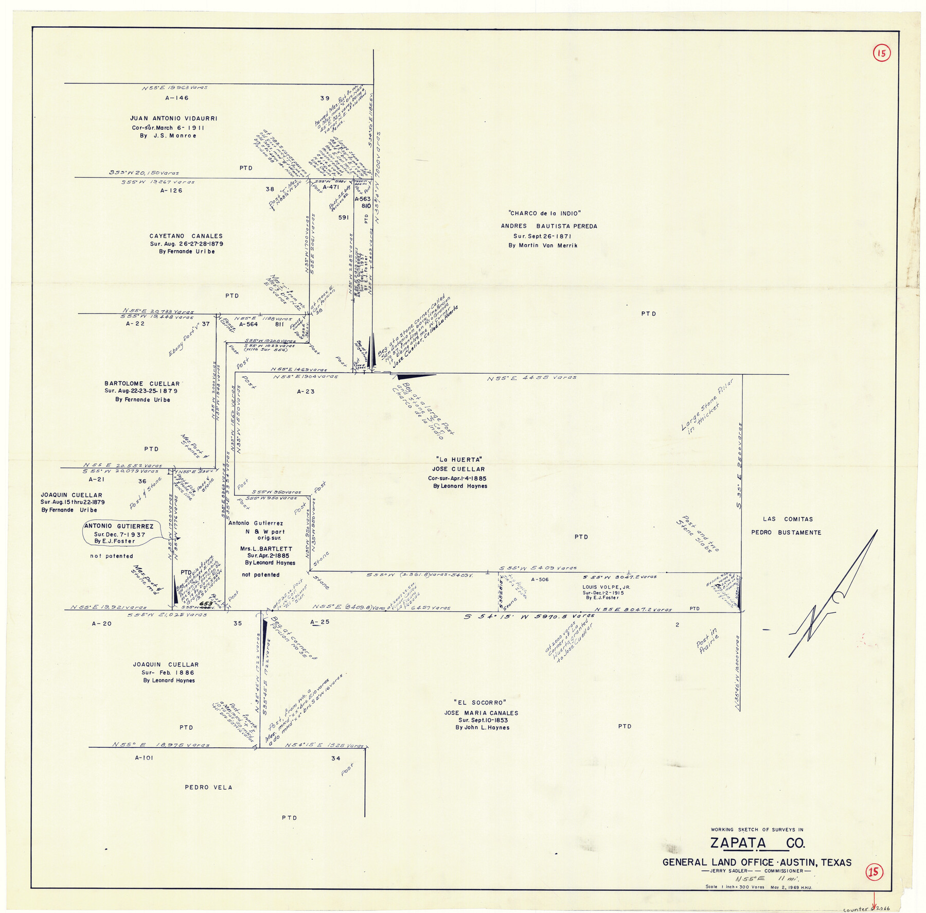
Zapata County Working Sketch 15
-
Map/Doc
62066
-
Collection
General Map Collection
-
Object Dates
5/2/1969 (Creation Date)
-
People and Organizations
Herbert H. Ulbricht (Draftsman)
-
Counties
Zapata
-
Subjects
Surveying Working Sketch
-
Height x Width
38.2 x 38.7 inches
97.0 x 98.3 cm
-
Scale
1" = 300 varas
Part of: General Map Collection
Tarrant County Working Sketch 13

Print $20.00
- Digital $50.00
Tarrant County Working Sketch 13
1987
Size 22.4 x 30.8 inches
Map/Doc 62430
Rains County Working Sketch 5

Print $20.00
- Digital $50.00
Rains County Working Sketch 5
1950
Size 35.2 x 42.0 inches
Map/Doc 71831
Edwards County Sketch File 35a

Print $20.00
- Digital $50.00
Edwards County Sketch File 35a
1928
Size 33.0 x 23.5 inches
Map/Doc 11435
Flight Mission No. DAG-22K, Frame 74, Matagorda County

Print $20.00
- Digital $50.00
Flight Mission No. DAG-22K, Frame 74, Matagorda County
1953
Size 18.8 x 22.5 inches
Map/Doc 86461
Val Verde County Sketch File Z7

Print $20.00
- Digital $50.00
Val Verde County Sketch File Z7
Size 25.6 x 17.2 inches
Map/Doc 12552
Webb County Working Sketch 93

Print $20.00
- Digital $50.00
Webb County Working Sketch 93
1989
Size 15.7 x 20.1 inches
Map/Doc 72460

Maps of Gulf Intracoastal Waterway, Texas - Sabine River to the Rio Grande and connecting waterways including ship channels

Print $20.00
- Digital $50.00
Maps of Gulf Intracoastal Waterway, Texas - Sabine River to the Rio Grande and connecting waterways including ship channels
1966
Size 15.7 x 22.0 inches
Map/Doc 61986
Fractional Township No. 8 South Range No. 18 East of the Indian Meridian, Indian Territory

Print $20.00
- Digital $50.00
Fractional Township No. 8 South Range No. 18 East of the Indian Meridian, Indian Territory
1897
Size 19.2 x 24.3 inches
Map/Doc 75233

Jack County Boundary File 2

Print $48.00
- Digital $50.00
Jack County Boundary File 2
Size 14.3 x 8.8 inches
Map/Doc 55384
McLennan County Boundary File 1

Print $80.00
- Digital $50.00
McLennan County Boundary File 1
Size 19.4 x 12.3 inches
Map/Doc 56937
You may also like

Maverick County Sketch File 8

Print $8.00
- Digital $50.00
Maverick County Sketch File 8
1878
Size 11.5 x 6.5 inches
Map/Doc 31064
Flight Mission No. CRE-2R, Frame 82, Jackson County

Print $20.00
- Digital $50.00
Flight Mission No. CRE-2R, Frame 82, Jackson County
1956
Size 16.0 x 15.9 inches
Map/Doc 85354
Sutton County Rolled Sketch 36

Print $20.00
- Digital $50.00
Sutton County Rolled Sketch 36
1887
Size 27.3 x 33.4 inches
Map/Doc 7880
Schleicher County Rolled Sketch 5

Print $20.00
- Digital $50.00
Schleicher County Rolled Sketch 5
Size 19.3 x 23.8 inches
Map/Doc 7748
Jasper County Boundary File 4

Print $4.00
- Digital $50.00
Jasper County Boundary File 4
Size 14.4 x 8.9 inches
Map/Doc 55489
Township No. 1 North Range No. 27 West Indian Meridian

Print $20.00
- Digital $50.00
Township No. 1 North Range No. 27 West Indian Meridian
1875
Size 19.3 x 24.6 inches
Map/Doc 75170
Flight Mission No. BRE-1P, Frame 66, Nueces County

Print $20.00
- Digital $50.00
Flight Mission No. BRE-1P, Frame 66, Nueces County
1956
Size 18.5 x 22.4 inches
Map/Doc 86648
Bailey County Sketch File 11a

Print $4.00
- Digital $50.00
Bailey County Sketch File 11a
1912
Size 8.4 x 11.1 inches
Map/Doc 13967
The Chief Justice County of Liberty. Lands in Conflict with Harrisburg County

Print $20.00
The Chief Justice County of Liberty. Lands in Conflict with Harrisburg County
2020
Size 20.5 x 21.7 inches
Map/Doc 96056
Brewster County Working Sketch Graphic Index, East Part, Sheet 1 (Sketches 1 to 111)

Print $20.00
- Digital $50.00
Brewster County Working Sketch Graphic Index, East Part, Sheet 1 (Sketches 1 to 111)
1952
Size 47.4 x 29.6 inches
Map/Doc 76476
Map of the Recognised Line M. EL. P. & P. R. R. from East Line of Bexar Land District to El Paso

Print $20.00
- Digital $50.00
Map of the Recognised Line M. EL. P. & P. R. R. from East Line of Bexar Land District to El Paso
1857
Size 7.5 x 41.8 inches
Map/Doc 2218