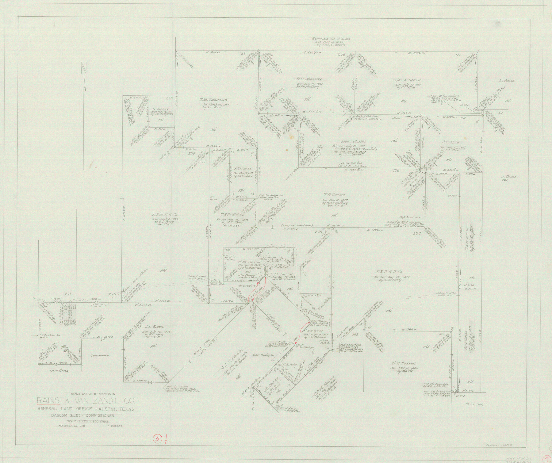
Rains County Working Sketch 5
-
Map/Doc
71831
-
Collection
General Map Collection
-
Object Dates
11/28/1950 (Creation Date)
-
Counties
Rains Van Zandt
-
Subjects
Surveying Working Sketch
-
Height x Width
35.2 x 42.0 inches
89.4 x 106.7 cm
-
Scale
1" = 200 varas
Part of: General Map Collection
Matagorda County Rolled Sketch 37C

Print $20.00
- Digital $50.00
Matagorda County Rolled Sketch 37C
Size 11.6 x 14.3 inches
Map/Doc 10197
Harbor Pass and Bar at Brazos Santiago, Texas

Print $20.00
- Digital $50.00
Harbor Pass and Bar at Brazos Santiago, Texas
1879
Size 18.2 x 27.2 inches
Map/Doc 73001
Map of Red River County

Print $20.00
- Digital $50.00
Map of Red River County
1842
Size 25.2 x 23.1 inches
Map/Doc 78369
Newton County

Print $20.00
- Digital $50.00
Newton County
1946
Size 46.8 x 40.9 inches
Map/Doc 77383
La Salle County Rolled Sketch 7

Print $40.00
- Digital $50.00
La Salle County Rolled Sketch 7
Size 38.7 x 48.0 inches
Map/Doc 10652
Galveston County Sketch File 31

Print $20.00
- Digital $50.00
Galveston County Sketch File 31
1916
Size 23.7 x 13.6 inches
Map/Doc 11534
[Sketch for Mineral Application 26501 - Sabine River, T. A. Oldhausen]
![2839, [Sketch for Mineral Application 26501 - Sabine River, T. A. Oldhausen], General Map Collection](https://historictexasmaps.com/wmedia_w700/maps/2839.tif.jpg)
Print $20.00
- Digital $50.00
[Sketch for Mineral Application 26501 - Sabine River, T. A. Oldhausen]
1931
Size 17.7 x 36.4 inches
Map/Doc 2839
East Part of West Bay and Southwest Part of Galveston Bay, Galveston County, showing Subdivision for Mineral Development

Print $40.00
- Digital $50.00
East Part of West Bay and Southwest Part of Galveston Bay, Galveston County, showing Subdivision for Mineral Development
1963
Size 42.2 x 58.2 inches
Map/Doc 1906
Tarrant County Working Sketch 1

Print $20.00
- Digital $50.00
Tarrant County Working Sketch 1
1939
Size 12.2 x 18.9 inches
Map/Doc 62418
Controlled Mosaic by Jack Amman Photogrammetric Engineers, Inc - Sheet 10

Print $20.00
- Digital $50.00
Controlled Mosaic by Jack Amman Photogrammetric Engineers, Inc - Sheet 10
1954
Size 20.0 x 24.0 inches
Map/Doc 83454
[Letters to and from Maj. W. J. Powell regarding surveys of Texas and Pacific Ry. Lands west of the Pecos. Blks 53-55, Township 1 & 2 map within]
![2249, [Letters to and from Maj. W. J. Powell regarding surveys of Texas and Pacific Ry. Lands west of the Pecos. Blks 53-55, Township 1 & 2 map within], General Map Collection](https://historictexasmaps.com/wmedia_w700/pdf_converted_jpg/qi_pdf_thumbnail_1039.jpg)
Print $124.00
- Digital $50.00
[Letters to and from Maj. W. J. Powell regarding surveys of Texas and Pacific Ry. Lands west of the Pecos. Blks 53-55, Township 1 & 2 map within]
1934
Size 10.2 x 15.4 inches
Map/Doc 2249
Wise County Rolled Sketch 6

Print $20.00
- Digital $50.00
Wise County Rolled Sketch 6
2000
Size 32.0 x 43.1 inches
Map/Doc 8280
You may also like
Liberty County Working Sketch 48

Print $20.00
- Digital $50.00
Liberty County Working Sketch 48
1954
Size 17.7 x 18.9 inches
Map/Doc 70507
Flight Mission No. CRC-1R, Frame 39, Chambers County

Print $20.00
- Digital $50.00
Flight Mission No. CRC-1R, Frame 39, Chambers County
1956
Size 18.8 x 22.4 inches
Map/Doc 84707
Map of Tom Green Co.

Print $40.00
- Digital $50.00
Map of Tom Green Co.
1880
Size 42.7 x 109.3 inches
Map/Doc 81917
Map of the Fort Worth & Denver City Ry., Dallam County, Texas

Print $40.00
- Digital $50.00
Map of the Fort Worth & Denver City Ry., Dallam County, Texas
1887
Size 21.3 x 111.8 inches
Map/Doc 64352
Hardeman County Sketch File 10

Print $4.00
- Digital $50.00
Hardeman County Sketch File 10
1884
Size 13.2 x 8.3 inches
Map/Doc 25006
Presidio County Rolled Sketch 37

Print $20.00
- Digital $50.00
Presidio County Rolled Sketch 37
Size 15.6 x 22.6 inches
Map/Doc 7335
Leon County Rolled Sketch 33

Print $20.00
- Digital $50.00
Leon County Rolled Sketch 33
1997
Size 26.3 x 36.7 inches
Map/Doc 6617
Gaines County Rolled Sketch G3A

Print $20.00
- Digital $50.00
Gaines County Rolled Sketch G3A
1902
Size 22.5 x 31.1 inches
Map/Doc 5947
Reeves County Working Sketch 43

Print $20.00
- Digital $50.00
Reeves County Working Sketch 43
1974
Size 43.2 x 37.1 inches
Map/Doc 63486
Bee County Working Sketch 14

Print $20.00
- Digital $50.00
Bee County Working Sketch 14
1948
Size 22.2 x 17.7 inches
Map/Doc 67264

Menard County Boundary File 6

Print $6.00
- Digital $50.00
Menard County Boundary File 6
Size 11.2 x 8.7 inches
Map/Doc 57086