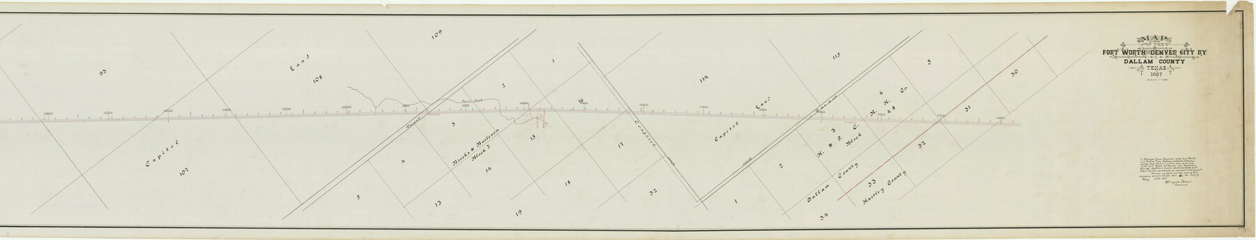
Map of the Fort Worth & Denver City Ry., Dallam County, Texas
Z-2-91
-
Map/Doc
64352
-
Collection
General Map Collection
-
Object Dates
1887 (Creation Date)
1888/6/7 (File Date)
-
Counties
Dallam Hartley
-
Subjects
Railroads
-
Height x Width
21.3 x 111.8 inches
54.1 x 284.0 cm
-
Medium
paper, manuscript
-
Scale
1"=1000'
-
Comments
Segment 1; see counter no. 64352 for segment 2.
-
Features
FW&DC
Perico Creek
Part of: General Map Collection
Nueces County Rolled Sketch 33

Print $47.00
- Digital $50.00
Nueces County Rolled Sketch 33
1953
Size 10.0 x 15.1 inches
Map/Doc 47612
Loving County Rolled Sketch 6

Print $20.00
- Digital $50.00
Loving County Rolled Sketch 6
Size 21.2 x 17.5 inches
Map/Doc 6637
Marion County Working Sketch 20

Print $20.00
- Digital $50.00
Marion County Working Sketch 20
1958
Size 25.1 x 28.2 inches
Map/Doc 70796
Leon County Rolled Sketch 32

Print $20.00
- Digital $50.00
Leon County Rolled Sketch 32
Size 34.2 x 40.7 inches
Map/Doc 6616
Montgomery County Sketch File 5

Print $5.00
- Digital $50.00
Montgomery County Sketch File 5
Size 9.8 x 16.4 inches
Map/Doc 31779
Map of Austin Co.

Print $40.00
- Digital $50.00
Map of Austin Co.
1895
Size 49.3 x 43.6 inches
Map/Doc 4795
America's Fun-Tier: Texas 1965 Official Highway Travel Map

Digital $50.00
America's Fun-Tier: Texas 1965 Official Highway Travel Map
Size 28.2 x 36.4 inches
Map/Doc 94325
Traced from Genl. Arista's map captured by the American Army under Genl. Taylor at Resaca de la Palma 9th May '46 and presented to James K. Polk, President U. States

Print $20.00
- Digital $50.00
Traced from Genl. Arista's map captured by the American Army under Genl. Taylor at Resaca de la Palma 9th May '46 and presented to James K. Polk, President U. States
1846
Size 18.4 x 27.6 inches
Map/Doc 73059
Flight Mission No. DIX-3P, Frame 172, Aransas County

Print $20.00
- Digital $50.00
Flight Mission No. DIX-3P, Frame 172, Aransas County
1956
Size 17.7 x 18.3 inches
Map/Doc 83778
Marion County Rolled Sketch S

Print $20.00
- Digital $50.00
Marion County Rolled Sketch S
1937
Size 18.8 x 18.1 inches
Map/Doc 6663
Reeves County Sketch File 28

Print $12.00
- Digital $50.00
Reeves County Sketch File 28
2003
Size 14.3 x 8.8 inches
Map/Doc 78496
Flight Mission No. CRC-1R, Frame 94, Chambers County

Print $20.00
- Digital $50.00
Flight Mission No. CRC-1R, Frame 94, Chambers County
1956
Size 18.8 x 22.5 inches
Map/Doc 84709
You may also like
Hardeman County Sketch File 5

Print $6.00
- Digital $50.00
Hardeman County Sketch File 5
Size 12.9 x 4.4 inches
Map/Doc 24994
Ochiltree County Boundary File 2

Print $4.00
- Digital $50.00
Ochiltree County Boundary File 2
Size 7.7 x 8.6 inches
Map/Doc 57675
Flight Mission No. DCL-4C, Frame 4, Kenedy County

Print $20.00
- Digital $50.00
Flight Mission No. DCL-4C, Frame 4, Kenedy County
1943
Size 18.7 x 22.3 inches
Map/Doc 85805
Wood County Working Sketch 16

Print $20.00
- Digital $50.00
Wood County Working Sketch 16
1987
Size 21.7 x 17.7 inches
Map/Doc 62016
Andrews County Rolled Sketch 34

Print $20.00
- Digital $50.00
Andrews County Rolled Sketch 34
1955
Size 34.9 x 40.0 inches
Map/Doc 8913
Brewster County Rolled Sketch 114

Print $20.00
- Digital $50.00
Brewster County Rolled Sketch 114
1964
Size 11.6 x 17.3 inches
Map/Doc 5273
Collingsworth County Sketch File 5

Print $20.00
- Digital $50.00
Collingsworth County Sketch File 5
1891
Size 32.0 x 24.3 inches
Map/Doc 11132

Schleicher County Sketch File 11

Print $20.00
- Digital $50.00
Schleicher County Sketch File 11
1912
Size 21.5 x 30.5 inches
Map/Doc 12298
[Sketch showing the southwest part of the Glidden and Sanborn Addition]
![91746, [Sketch showing the southwest part of the Glidden and Sanborn Addition], Twichell Survey Records](https://historictexasmaps.com/wmedia_w700/maps/91746-1.tif.jpg)
Print $20.00
- Digital $50.00
[Sketch showing the southwest part of the Glidden and Sanborn Addition]
Size 20.0 x 29.3 inches
Map/Doc 91746
Bell County Rolled Sketch 1

Print $20.00
- Digital $50.00
Bell County Rolled Sketch 1
1954
Size 38.1 x 41.1 inches
Map/Doc 75938
San Patricio County Working Sketch Graphic Index

Print $20.00
- Digital $50.00
San Patricio County Working Sketch Graphic Index
1939
Size 36.6 x 47.9 inches
Map/Doc 76692