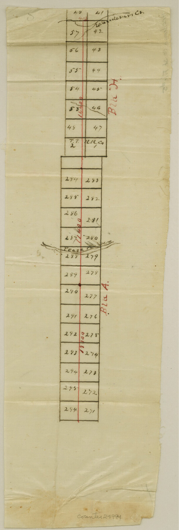
Hardeman County Sketch File 5
[Plat and field notes of connecting line]
-
Map/Doc
24994
-
Collection
General Map Collection
-
People and Organizations
W.J. Westmoreland (Surveyor/Engineer)
F.C. Ratcliff (Chainman)
R.P. Elliott (Chainman)
D.N. Robinson (GLO Clerk)
-
Counties
Hardeman Foard
-
Subjects
Surveying Sketch File
-
Height x Width
12.9 x 4.4 inches
32.8 x 11.2 cm
-
Medium
paper, manuscript
-
Features
Wanderers Creek
Pease River
Part of: General Map Collection
Nautical Chart 887-SC Intracoastal Waterway - Galveston Bay to Cedar Lakes including the Brazos and San Bernard Rivers, Texas

Print $40.00
- Digital $50.00
Nautical Chart 887-SC Intracoastal Waterway - Galveston Bay to Cedar Lakes including the Brazos and San Bernard Rivers, Texas
1971
Size 15.7 x 59.5 inches
Map/Doc 69938
Matagorda County Sketch File 7a

Print $8.00
- Digital $50.00
Matagorda County Sketch File 7a
1890
Size 14.2 x 8.9 inches
Map/Doc 30740
Marion County Working Sketch 9

Print $20.00
- Digital $50.00
Marion County Working Sketch 9
1940
Size 23.5 x 25.5 inches
Map/Doc 70784
Webb County Sketch File 46-1

Print $20.00
- Digital $50.00
Webb County Sketch File 46-1
1939
Size 24.9 x 15.3 inches
Map/Doc 12645
Edwards County Working Sketch 74

Print $20.00
- Digital $50.00
Edwards County Working Sketch 74
1959
Size 23.6 x 38.4 inches
Map/Doc 68950
Grimes County Working Sketch 7

Print $20.00
- Digital $50.00
Grimes County Working Sketch 7
1963
Size 27.2 x 33.0 inches
Map/Doc 63298
Reeves County Working Sketch 46

Print $40.00
- Digital $50.00
Reeves County Working Sketch 46
1974
Size 52.4 x 37.2 inches
Map/Doc 63489
Kimble County Working Sketch 19

Print $20.00
- Digital $50.00
Kimble County Working Sketch 19
1926
Size 38.7 x 34.8 inches
Map/Doc 70087
Edwards County

Print $20.00
- Digital $50.00
Edwards County
1893
Size 25.8 x 29.4 inches
Map/Doc 3506
Orange County Rolled Sketch 32

Print $20.00
- Digital $50.00
Orange County Rolled Sketch 32
1982
Size 33.6 x 22.5 inches
Map/Doc 7188
Clay County Rolled Sketch 4A

Print $20.00
- Digital $50.00
Clay County Rolled Sketch 4A
1949
Size 22.0 x 24.0 inches
Map/Doc 5498
Guadalupe County Sketch File 5a

Print $12.00
- Digital $50.00
Guadalupe County Sketch File 5a
1869
Size 12.6 x 8.0 inches
Map/Doc 42205
You may also like
Smith County Boundary File 80

Print $8.00
- Digital $50.00
Smith County Boundary File 80
Size 9.0 x 6.2 inches
Map/Doc 58797
Padre Island National Seashore

Print $4.00
- Digital $50.00
Padre Island National Seashore
Size 16.1 x 22.1 inches
Map/Doc 60531
The Chief Justice County of Gonzales. Lands in Conflict with Victoria County

Print $20.00
The Chief Justice County of Gonzales. Lands in Conflict with Victoria County
2020
Size 22.3 x 21.7 inches
Map/Doc 96048
Flight Mission No. BRE-1P, Frame 103, Nueces County

Print $20.00
- Digital $50.00
Flight Mission No. BRE-1P, Frame 103, Nueces County
1956
Size 18.4 x 22.2 inches
Map/Doc 86674

Hill County Sketch file 28

Print $33.00
- Digital $50.00
Hill County Sketch file 28
1987
Size 11.3 x 8.9 inches
Map/Doc 26530
Menard County Sketch File 15

Print $8.00
- Digital $50.00
Menard County Sketch File 15
1892
Size 12.9 x 8.3 inches
Map/Doc 31510
Freestone County Working Sketch 26

Print $20.00
- Digital $50.00
Freestone County Working Sketch 26
1907
Size 27.7 x 30.3 inches
Map/Doc 69268
Johnson County Rolled Sketch 2

Print $20.00
- Digital $50.00
Johnson County Rolled Sketch 2
1956
Size 20.6 x 22.3 inches
Map/Doc 6447
Stephens County Sketch File B

Print $9.00
- Digital $50.00
Stephens County Sketch File B
1919
Size 13.2 x 8.7 inches
Map/Doc 37070
Navigation Maps of Gulf Intracoastal Waterway, Port Arthur to Brownsville, Texas

Print $4.00
- Digital $50.00
Navigation Maps of Gulf Intracoastal Waterway, Port Arthur to Brownsville, Texas
1951
Size 16.7 x 21.5 inches
Map/Doc 65439
Flight Mission No. BRA-7M, Frame 202, Jefferson County

Print $20.00
- Digital $50.00
Flight Mission No. BRA-7M, Frame 202, Jefferson County
1953
Size 18.6 x 22.3 inches
Map/Doc 85570