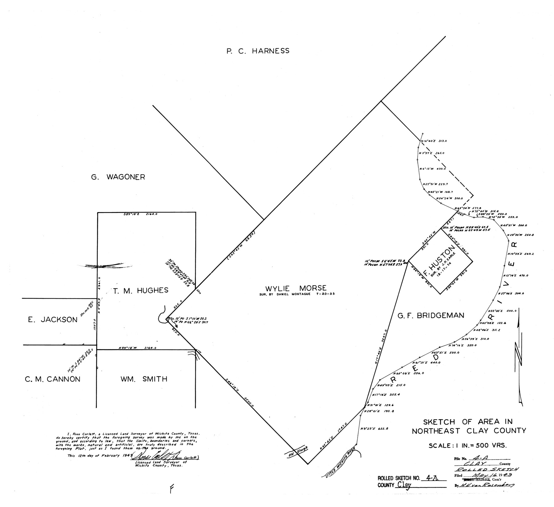
Clay County Rolled Sketch 4A
Sketch of Area in Northeast Clay County - Wiley Morse and Adjoining Surveys
-
Map/Doc
5498
-
Collection
General Map Collection
-
Object Dates
1949/2/12 (Creation Date)
1949/5/16 (File Date)
-
People and Organizations
Ross Corlett (Surveyor/Engineer)
-
Counties
Clay
-
Subjects
Surveying Rolled Sketch
-
Height x Width
22.0 x 24.0 inches
55.9 x 61.0 cm
-
Scale
1" = 500 varas
Part of: General Map Collection
Brewster County Rolled Sketch 6

Print $40.00
- Digital $50.00
Brewster County Rolled Sketch 6
Size 43.0 x 66.2 inches
Map/Doc 75944
[Kansas City, Mexico & Orient]
![64268, [Kansas City, Mexico & Orient], General Map Collection](https://historictexasmaps.com/wmedia_w700/maps/64268-1.tif.jpg)
Print $40.00
- Digital $50.00
[Kansas City, Mexico & Orient]
1904
Size 16.2 x 123.7 inches
Map/Doc 64268
Kinney County Working Sketch 51

Print $20.00
- Digital $50.00
Kinney County Working Sketch 51
1980
Size 34.6 x 47.2 inches
Map/Doc 70233
Flight Mission No. DAG-21K, Frame 37, Matagorda County

Print $20.00
- Digital $50.00
Flight Mission No. DAG-21K, Frame 37, Matagorda County
1952
Size 18.5 x 22.4 inches
Map/Doc 86404
Parker County Sketch File 48

Print $20.00
- Digital $50.00
Parker County Sketch File 48
1858
Size 17.6 x 22.3 inches
Map/Doc 12152
Wilbarger County Working Sketch 16

Print $20.00
- Digital $50.00
Wilbarger County Working Sketch 16
1955
Size 32.7 x 19.9 inches
Map/Doc 72554
Matagorda County Rolled Sketch 39

Print $40.00
- Digital $50.00
Matagorda County Rolled Sketch 39
1973
Size 24.4 x 114.0 inches
Map/Doc 10743
Map of Defunct and Ghost Counties in Texas

Print $20.00
- Digital $50.00
Map of Defunct and Ghost Counties in Texas
1939
Size 17.4 x 18.6 inches
Map/Doc 4805
Sketch C Showing the Progress of the Survey in Section III From 1843 to 1852

Print $20.00
- Digital $50.00
Sketch C Showing the Progress of the Survey in Section III From 1843 to 1852
1852
Size 36.2 x 25.6 inches
Map/Doc 97201
Liberty County Working Sketch 72

Print $20.00
- Digital $50.00
Liberty County Working Sketch 72
1977
Size 25.8 x 28.7 inches
Map/Doc 70532
Territory served by the Galveston Bay Ports, Tex.

Print $20.00
- Digital $50.00
Territory served by the Galveston Bay Ports, Tex.
1924
Size 17.1 x 16.0 inches
Map/Doc 97165
Hudspeth County Sketch File 26

Print $20.00
- Digital $50.00
Hudspeth County Sketch File 26
Size 42.5 x 23.9 inches
Map/Doc 10496
You may also like
Fort Bend County Rolled Sketch 2

Print $20.00
- Digital $50.00
Fort Bend County Rolled Sketch 2
1954
Size 24.4 x 28.6 inches
Map/Doc 5892
Lampasas County Boundary File 6

Print $40.00
- Digital $50.00
Lampasas County Boundary File 6
Size 9.1 x 7.8 inches
Map/Doc 56136
The Republic County of Montgomery. December 31, 1838

Print $20.00
The Republic County of Montgomery. December 31, 1838
2020
Size 19.9 x 21.7 inches
Map/Doc 96236

Stephens County Working Sketch 9

Print $20.00
- Digital $50.00
Stephens County Working Sketch 9
1920
Size 16.3 x 14.6 inches
Map/Doc 63952
Galveston County Rolled Sketch 41

Print $20.00
- Digital $50.00
Galveston County Rolled Sketch 41
1988
Size 23.1 x 37.0 inches
Map/Doc 5972

Orange County Rolled Sketch 16

Print $20.00
- Digital $50.00
Orange County Rolled Sketch 16
Size 42.2 x 30.4 inches
Map/Doc 41813
Flight Mission No. DCL-7C, Frame 117, Kenedy County

Print $20.00
- Digital $50.00
Flight Mission No. DCL-7C, Frame 117, Kenedy County
1943
Size 18.4 x 22.3 inches
Map/Doc 86082
[Township 3 North, Block 34]
![91208, [Township 3 North, Block 34], Twichell Survey Records](https://historictexasmaps.com/wmedia_w700/maps/91208-1.tif.jpg)
Print $3.00
- Digital $50.00
[Township 3 North, Block 34]
Size 10.2 x 14.0 inches
Map/Doc 91208
Liberty County Sketch File 38

Print $22.00
- Digital $50.00
Liberty County Sketch File 38
1899
Size 13.9 x 8.9 inches
Map/Doc 29983
Real County Working Sketch 1

Print $20.00
- Digital $50.00
Real County Working Sketch 1
Size 16.5 x 18.8 inches
Map/Doc 71893