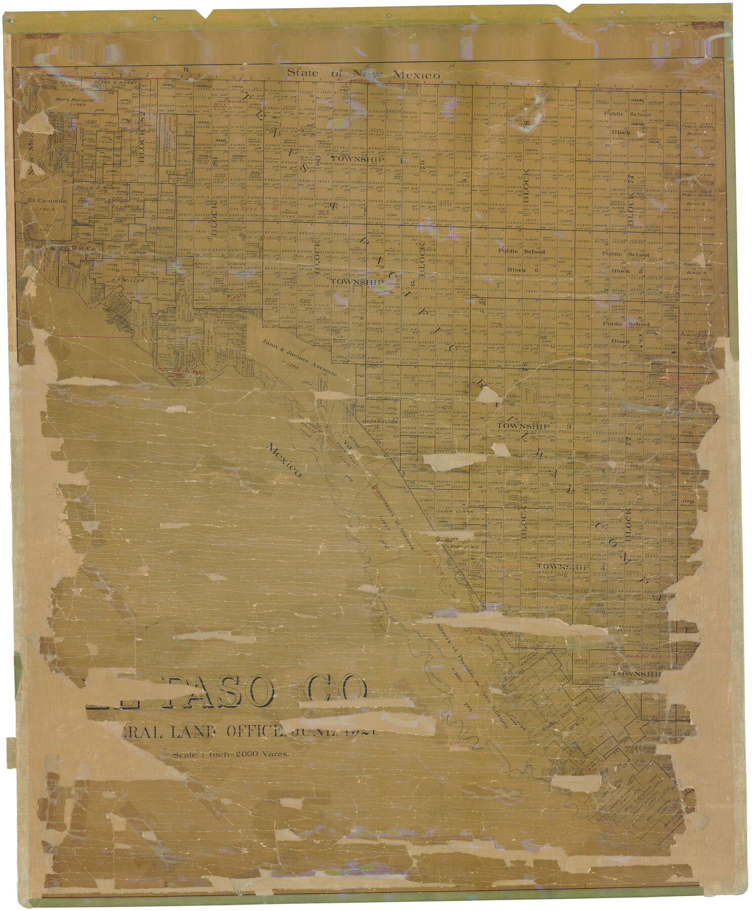
El Paso Co.
- 
                          Map/Doc1821
- 
                            CollectionGeneral Map Collection
- 
                            Object Dates6/1921 (Creation Date)
- 
                            CountiesEl Paso
- 
                            SubjectsCounty
- 
                            Height x Width50.6 x 42.1 inches128.5 x 106.9 cm
- 
                            CommentsConservation funded in 2008 by Friends of the Texas General Land Office.
- 
                            FeaturesRio ViejoSA&MGSan ElizarioSocorroYsletaUS Highway 62Hueco TanksTornilloFabensFoot HillsGH&SARiveraAnthonyEl PasoRio GrandeFort BlissTobinEP&NERGEP&SFCanutilloVintonNewmanLa Tuna
Part of: General Map Collection
            Wharton County Rolled Sketch 6


                                            Print $20.00                    
                                             -                         Digital $50.00                                    
                Wharton County Rolled Sketch 6
1901
Size 23.7 x 30.0 inches
                                Map/Doc 8230
            
            Crane County Working Sketch 9


                                            Print $20.00                    
                                             -                         Digital $50.00                                    
                Crane County Working Sketch 9
1937
Size 47.6 x 42.8 inches
                                Map/Doc 68286
            
            Stonewall County Working Sketch 27


                                            Print $20.00                    
                                             -                         Digital $50.00                                    
                Stonewall County Working Sketch 27
1976
Size 20.7 x 29.9 inches
                                Map/Doc 62334
            
            Crane County Rolled Sketch 14


                                            Print $46.00                    
                                             -                         Digital $50.00                                    
                Crane County Rolled Sketch 14
1935
Size 37.1 x 31.6 inches
                                Map/Doc 8680
            
            Map of the Recognised Line M. EL. P. & P. R. R. from East Line of Bexar Land District to El Paso


                                            Print $20.00                    
                                             -                         Digital $50.00                                    
                Map of the Recognised Line M. EL. P. & P. R. R. from East Line of Bexar Land District to El Paso
1857
Size 7.5 x 41.8 inches
                                Map/Doc 2218
            
            Polk County Sketch File 36


                                            Print $46.00                    
                                             -                         Digital $50.00                                    
                Polk County Sketch File 36
1908
Size 13.8 x 8.6 inches
                                Map/Doc 34236
            
            Harbor Pass and Bar at Brazos Santiago, Texas


                                            Print $20.00                    
                                             -                         Digital $50.00                                    
                Harbor Pass and Bar at Brazos Santiago, Texas
1871
Size 26.8 x 18.3 inches
                                Map/Doc 72984
            
            Henderson County Working Sketch 11


                                            Print $20.00                    
                                             -                         Digital $50.00                                    
                Henderson County Working Sketch 11
1914
Size 20.7 x 22.5 inches
                                Map/Doc 66144
            
            Throckmorton County


                                            Print $20.00                    
                                             -                         Digital $50.00                                    
                Throckmorton County
1943
Size 40.1 x 32.8 inches
                                Map/Doc 77435
            
            Dallam County Rolled Sketch 8


                                            Print $20.00                    
                                             -                         Digital $50.00                                    
                Dallam County Rolled Sketch 8
1949
Size 37.7 x 26.3 inches
                                Map/Doc 5686
            
            Go Turnpike! Dallas-Fort Worth Turnpike (Verso)


            Go Turnpike! Dallas-Fort Worth Turnpike (Verso)
1963
Size 11.2 x 17.2 inches
                                Map/Doc 94178
            
            Marion County Working Sketch 46


                                            Print $20.00                    
                                             -                         Digital $50.00                                    
                Marion County Working Sketch 46
2011
Size 21.4 x 29.1 inches
                                Map/Doc 90032
            You may also like
            Nueces County Rolled Sketch 89


                                            Print $235.00                    
                                    
                Nueces County Rolled Sketch 89
1983
Size 18.0 x 24.2 inches
                                Map/Doc 6991
            
            North Part Brewster Co.


                                            Print $40.00                    
                                             -                         Digital $50.00                                    
                North Part Brewster Co.
1914
Size 40.7 x 48.5 inches
                                Map/Doc 66730
            
            Map of Fannin County


                                            Print $20.00                    
                                             -                         Digital $50.00                                    
                Map of Fannin County
1866
Size 21.9 x 18.1 inches
                                Map/Doc 3534
            
            Zapata County Rolled Sketch 25


                                            Print $20.00                    
                                             -                         Digital $50.00                                    
                Zapata County Rolled Sketch 25
Size 45.7 x 37.9 inches
                                Map/Doc 10172
            
            Flight Mission No. BQR-16K, Frame 37, Brazoria County


                                            Print $20.00                    
                                             -                         Digital $50.00                                    
                Flight Mission No. BQR-16K, Frame 37, Brazoria County
1952
Size 18.6 x 22.3 inches
                                Map/Doc 84104
            
            Childress County Rolled Sketch 18


                                            Print $20.00                    
                                             -                         Digital $50.00                                    
                Childress County Rolled Sketch 18
1913
Size 17.6 x 39.0 inches
                                Map/Doc 5451
            
            Harris County Working Sketch 117


                                            Print $20.00                    
                                             -                         Digital $50.00                                    
                Harris County Working Sketch 117
1984
Size 28.2 x 25.5 inches
                                Map/Doc 66009
            
            Jasper County Boundary File 4a


                                            Print $20.00                    
                                             -                         Digital $50.00                                    
                Jasper County Boundary File 4a
Size 36.6 x 17.6 inches
                                Map/Doc 55491
            
            Stonewall County Rolled Sketch 11A


                                            Print $20.00                    
                                             -                         Digital $50.00                                    
                Stonewall County Rolled Sketch 11A
Size 33.4 x 28.2 inches
                                Map/Doc 7868
            
            [River Sections 58-62 and vicinity]
            
                                    ![91587, [River Sections 58-62 and vicinity], Twichell Survey Records](https://historictexasmaps.com/wmedia_w700/maps/91587-1.tif.jpg) 


    ![91587, [River Sections 58-62 and vicinity], Twichell Survey Records](https://historictexasmaps.com/wmedia_w700/maps/91587-1.tif.jpg) 
                                
            
                                            Print $20.00                    
                                             -                         Digital $50.00                                    
                [River Sections 58-62 and vicinity]
Size 17.6 x 14.6 inches
                                Map/Doc 91587
            
            Brazos County Rolled Sketch 6


                                            Print $20.00                    
                                             -                         Digital $50.00                                    
                Brazos County Rolled Sketch 6
1979
Size 24.3 x 36.4 inches
                                Map/Doc 5190
            
            Flight Mission No. DAG-17K, Frame 143, Matagorda County


                                            Print $20.00                    
                                             -                         Digital $50.00                                    
                Flight Mission No. DAG-17K, Frame 143, Matagorda County
1952
Size 16.4 x 16.4 inches
                                Map/Doc 86360
            