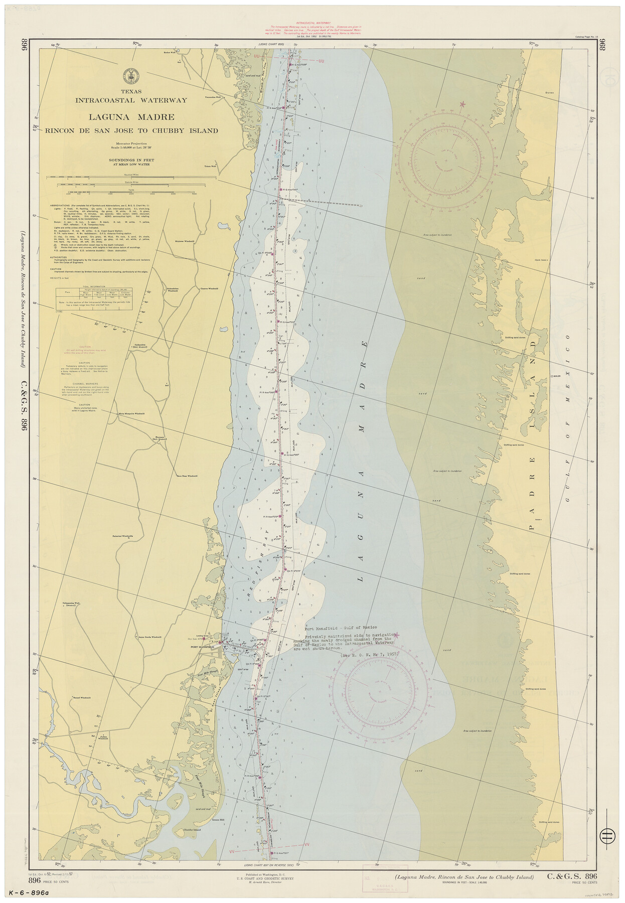
Texas Intracoastal Waterway - Laguna Madre - Rincon de San Jose to Chubby Island
Texas Intracoastal Waterway - Laguna Madre - Chubby Island to Stover Point
K-6-896a; K-6-897a
-
Map/Doc
73512
-
Collection
General Map Collection
-
Object Dates
2/11/1957 (Creation Date)
-
Counties
Kenedy Willacy
-
Subjects
Nautical Charts
-
Height x Width
39.2 x 27.1 inches
99.6 x 68.8 cm
Part of: General Map Collection
Presidio County Working Sketch 45

Print $20.00
- Digital $50.00
Presidio County Working Sketch 45
Size 25.2 x 20.0 inches
Map/Doc 71722
Galveston County Rolled Sketch 42

Print $20.00
- Digital $50.00
Galveston County Rolled Sketch 42
1982
Size 42.9 x 40.6 inches
Map/Doc 9021
San Saba County Sketch File 19

Print $8.00
- Digital $50.00
San Saba County Sketch File 19
1873
Size 12.8 x 8.1 inches
Map/Doc 36466
Dallam County Boundary File 1

Print $12.00
- Digital $50.00
Dallam County Boundary File 1
Size 9.0 x 7.6 inches
Map/Doc 52047
Lavaca County Rolled Sketch 3

Print $20.00
- Digital $50.00
Lavaca County Rolled Sketch 3
1959
Size 42.8 x 32.8 inches
Map/Doc 9419
Bell County Working Sketch 19

Print $40.00
- Digital $50.00
Bell County Working Sketch 19
1994
Size 48.3 x 38.4 inches
Map/Doc 67359
Nolan County Sketch File 5

Print $40.00
- Digital $50.00
Nolan County Sketch File 5
Size 51.0 x 44.0 inches
Map/Doc 10558
Texas Highway Map Points of Interest, Recreational Facilities Guide, Special Events Calendar [Verso]
![94188, Texas Highway Map Points of Interest, Recreational Facilities Guide, Special Events Calendar [Verso], General Map Collection](https://historictexasmaps.com/wmedia_w700/maps/94188.tif.jpg)
Texas Highway Map Points of Interest, Recreational Facilities Guide, Special Events Calendar [Verso]
1963
Size 31.0 x 18.3 inches
Map/Doc 94188

Flight Mission No. CRK-8P, Frame 117, Refugio County

Print $20.00
- Digital $50.00
Flight Mission No. CRK-8P, Frame 117, Refugio County
1956
Size 18.1 x 22.0 inches
Map/Doc 86972
Marion County Working Sketch 23

Print $20.00
- Digital $50.00
Marion County Working Sketch 23
1960
Size 24.4 x 25.9 inches
Map/Doc 70799
Upton County Sketch File 40a

Print $40.00
- Digital $50.00
Upton County Sketch File 40a
1963
Size 11.2 x 18.3 inches
Map/Doc 38917
You may also like
Flight Mission No. BRE-1P, Frame 6, Nueces County

Print $20.00
- Digital $50.00
Flight Mission No. BRE-1P, Frame 6, Nueces County
1956
Size 18.2 x 22.1 inches
Map/Doc 86614
Bexar County Rolled Sketch 3

Print $20.00
- Digital $50.00
Bexar County Rolled Sketch 3
1873
Size 25.5 x 18.0 inches
Map/Doc 5136
Real County Working Sketch 17

Print $20.00
- Digital $50.00
Real County Working Sketch 17
1941
Size 18.8 x 24.3 inches
Map/Doc 71909
Hardin County Rolled Sketch MH

Print $21.00
- Digital $50.00
Hardin County Rolled Sketch MH
1936
Size 10.1 x 15.2 inches
Map/Doc 45760
Carson County Boundary File 8

Print $40.00
- Digital $50.00
Carson County Boundary File 8
Size 7.8 x 35.0 inches
Map/Doc 51171

San Jacinto County Working Sketch 44

Print $20.00
- Digital $50.00
San Jacinto County Working Sketch 44
1981
Size 20.6 x 11.4 inches
Map/Doc 63758
[Galveston, Harrisburg & San Antonio from El Paso to El Paso-Presidio county boundary]
![64719, [Galveston, Harrisburg & San Antonio from El Paso to El Paso-Presidio county boundary], General Map Collection](https://historictexasmaps.com/wmedia_w700/maps/64719.tif.jpg)
Print $40.00
- Digital $50.00
[Galveston, Harrisburg & San Antonio from El Paso to El Paso-Presidio county boundary]
Size 150.0 x 27.3 inches
Map/Doc 64719
W. Alvin Lloyd's Southern Rail-Road Map

Print $20.00
- Digital $50.00
W. Alvin Lloyd's Southern Rail-Road Map
1863
Size 18.4 x 23.7 inches
Map/Doc 97496
A Trip to Winter Garden District, Carrizo Springs, Texas in the Shallow Water Area of the Famous Artesian Belt

Print $20.00
- Digital $50.00
A Trip to Winter Garden District, Carrizo Springs, Texas in the Shallow Water Area of the Famous Artesian Belt
1920
Size 8.9 x 15.5 inches
Map/Doc 96766
Aransas County Rolled Sketch 35

Print $40.00
- Digital $50.00
Aransas County Rolled Sketch 35
2006
Size 37.5 x 50.0 inches
Map/Doc 83555
J. C. Davis Southeast Quarter, Section 3, Block E

Print $20.00
- Digital $50.00
J. C. Davis Southeast Quarter, Section 3, Block E
Size 30.3 x 29.8 inches
Map/Doc 92740