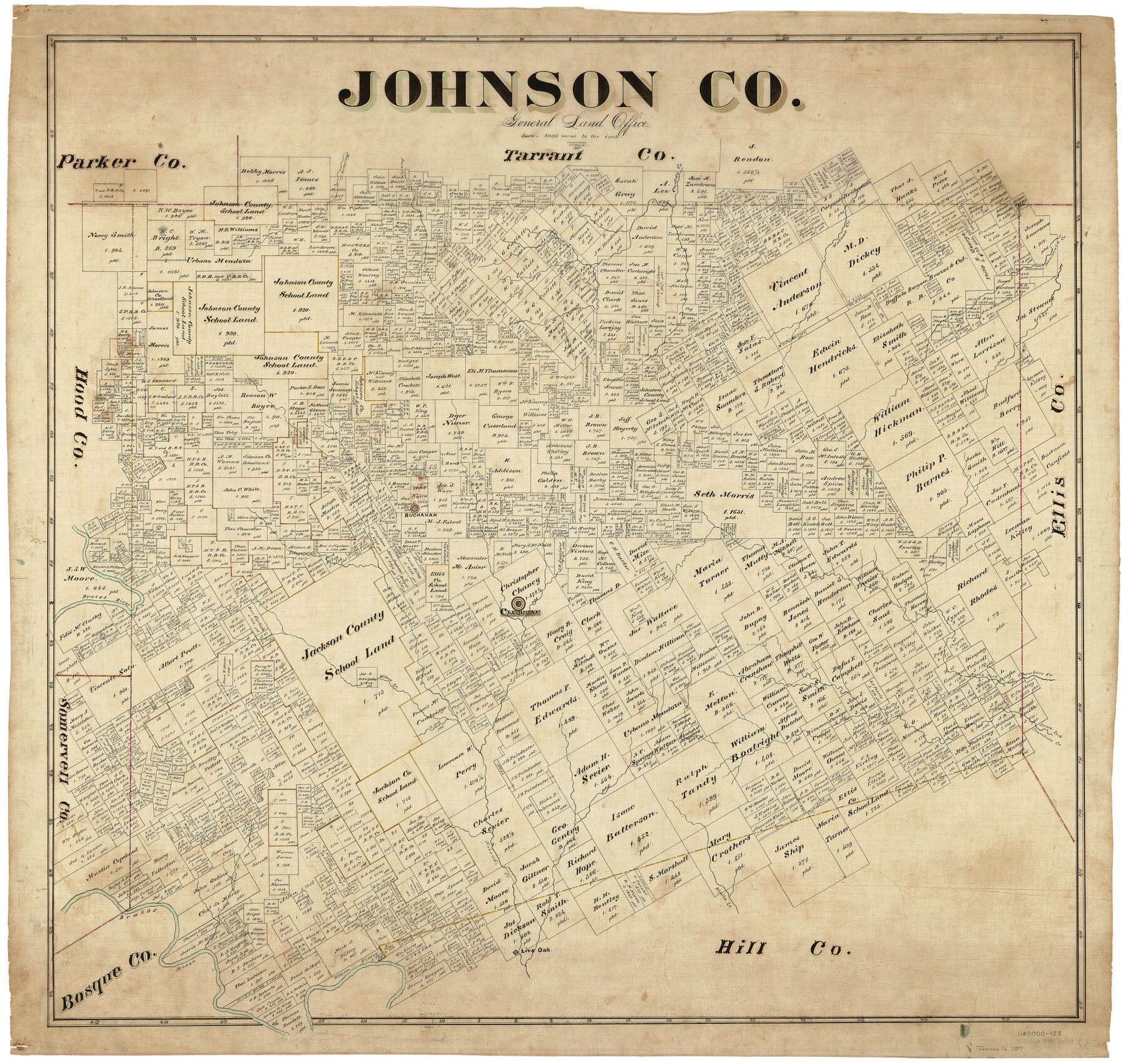
Johnson Co.
-
Map/Doc
4995
-
Collection
General Map Collection
-
Object Dates
1887 (Creation Date)
-
People and Organizations
F.G. Blau (Draftsman)
-
Counties
Johnson
-
Subjects
County
-
Height x Width
35.0 x 37.3 inches
88.9 x 94.7 cm
Part of: General Map Collection
St. Louis, Brownsville & Mexico

Print $40.00
- Digital $50.00
St. Louis, Brownsville & Mexico
1906
Size 20.0 x 127.8 inches
Map/Doc 89281
Trinity County Working Sketch 23

Print $20.00
- Digital $50.00
Trinity County Working Sketch 23
2010
Size 23.4 x 33.6 inches
Map/Doc 89259
Pecos County Rolled Sketch 28

Print $20.00
- Digital $50.00
Pecos County Rolled Sketch 28
1890
Size 18.9 x 38.5 inches
Map/Doc 7213
Somervell County Sketch File 4

Print $4.00
- Digital $50.00
Somervell County Sketch File 4
Size 6.4 x 8.8 inches
Map/Doc 36800
Edwards County Working Sketch 71

Print $20.00
- Digital $50.00
Edwards County Working Sketch 71
1957
Size 17.4 x 23.8 inches
Map/Doc 68947
Williamson County Sketch File 17

Print $8.00
- Digital $50.00
Williamson County Sketch File 17
1876
Size 6.5 x 8.1 inches
Map/Doc 40338
Real County Sketch File 6

Print $20.00
- Digital $50.00
Real County Sketch File 6
1931
Size 17.3 x 19.6 inches
Map/Doc 12229
Bowie County Working Sketch Graphic Index

Print $20.00
- Digital $50.00
Bowie County Working Sketch Graphic Index
1933
Size 38.9 x 47.1 inches
Map/Doc 76470
Coke County Rolled Sketch 19A

Print $20.00
- Digital $50.00
Coke County Rolled Sketch 19A
1954
Size 19.9 x 24.8 inches
Map/Doc 5520
Flight Mission No. BRA-9M, Frame 60, Jefferson County

Print $20.00
- Digital $50.00
Flight Mission No. BRA-9M, Frame 60, Jefferson County
1953
Size 18.6 x 22.4 inches
Map/Doc 85643
Map of Jack County

Print $20.00
- Digital $50.00
Map of Jack County
1874
Size 20.7 x 17.6 inches
Map/Doc 3704
Hemphill County Rolled Sketch 14

Print $20.00
- Digital $50.00
Hemphill County Rolled Sketch 14
1941
Size 45.0 x 22.2 inches
Map/Doc 9155
You may also like
Rio Grande - Rio Grande Sheet

Print $40.00
- Digital $50.00
Rio Grande - Rio Grande Sheet
1929
Size 53.9 x 27.3 inches
Map/Doc 65105
[J. Poitevent Blk. 1]
![90132, [J. Poitevent Blk. 1], Twichell Survey Records](https://historictexasmaps.com/wmedia_w700/maps/90132-1.tif.jpg)
Print $3.00
- Digital $50.00
[J. Poitevent Blk. 1]
Size 10.7 x 13.3 inches
Map/Doc 90132
Val Verde County Working Sketch 13

Print $20.00
- Digital $50.00
Val Verde County Working Sketch 13
1922
Size 24.8 x 25.3 inches
Map/Doc 72148
Baffin Bay, Texas from Penescal Triangulation Station to Bovido Triangulation Station

Print $40.00
- Digital $50.00
Baffin Bay, Texas from Penescal Triangulation Station to Bovido Triangulation Station
1881
Size 32.6 x 54.2 inches
Map/Doc 73484
Val Verde County Sketch File 17

Print $12.00
- Digital $50.00
Val Verde County Sketch File 17
Size 12.9 x 8.1 inches
Map/Doc 39219
Floyd County Sketch File 9

Print $20.00
- Digital $50.00
Floyd County Sketch File 9
1901
Size 22.1 x 15.3 inches
Map/Doc 11484
Chambers County NRC Article 33.136 Sketch 7

Print $28.00
- Digital $50.00
Chambers County NRC Article 33.136 Sketch 7
2011
Size 18.0 x 24.0 inches
Map/Doc 94753
Three Through Trains for Texas Travelers via Katy Line - Missouri, Kansas and Texas Railway from Chicago, St. Louis, Kansas City and a comprehensive local service reaching all points in Missouri, Kansas, Texas and Indian Territory

Three Through Trains for Texas Travelers via Katy Line - Missouri, Kansas and Texas Railway from Chicago, St. Louis, Kansas City and a comprehensive local service reaching all points in Missouri, Kansas, Texas and Indian Territory
Size 9.5 x 6.3 inches
Map/Doc 96605
Flight Mission No. DQO-8K, Frame 141, Galveston County

Print $20.00
- Digital $50.00
Flight Mission No. DQO-8K, Frame 141, Galveston County
1952
Size 18.6 x 22.4 inches
Map/Doc 85203
Burnet County Boundary File 9

Print $12.00
- Digital $50.00
Burnet County Boundary File 9
Size 14.1 x 8.6 inches
Map/Doc 50943
[Drawings of individual counties for Pressler and Langermann's 1879 Map of Texas]
![[Drawings of individual counties for Pressler and Langermann's 1879 Map of Texas]](https://historictexasmaps.com/wmedia_w700/maps/4864.tif.jpg)
Print $20.00
- Digital $50.00
[Drawings of individual counties for Pressler and Langermann's 1879 Map of Texas]
1878
Size 38.3 x 26.8 inches
Map/Doc 4864
Hardeman County Working Sketch 11

Print $40.00
- Digital $50.00
Hardeman County Working Sketch 11
1960
Size 40.0 x 58.1 inches
Map/Doc 63392