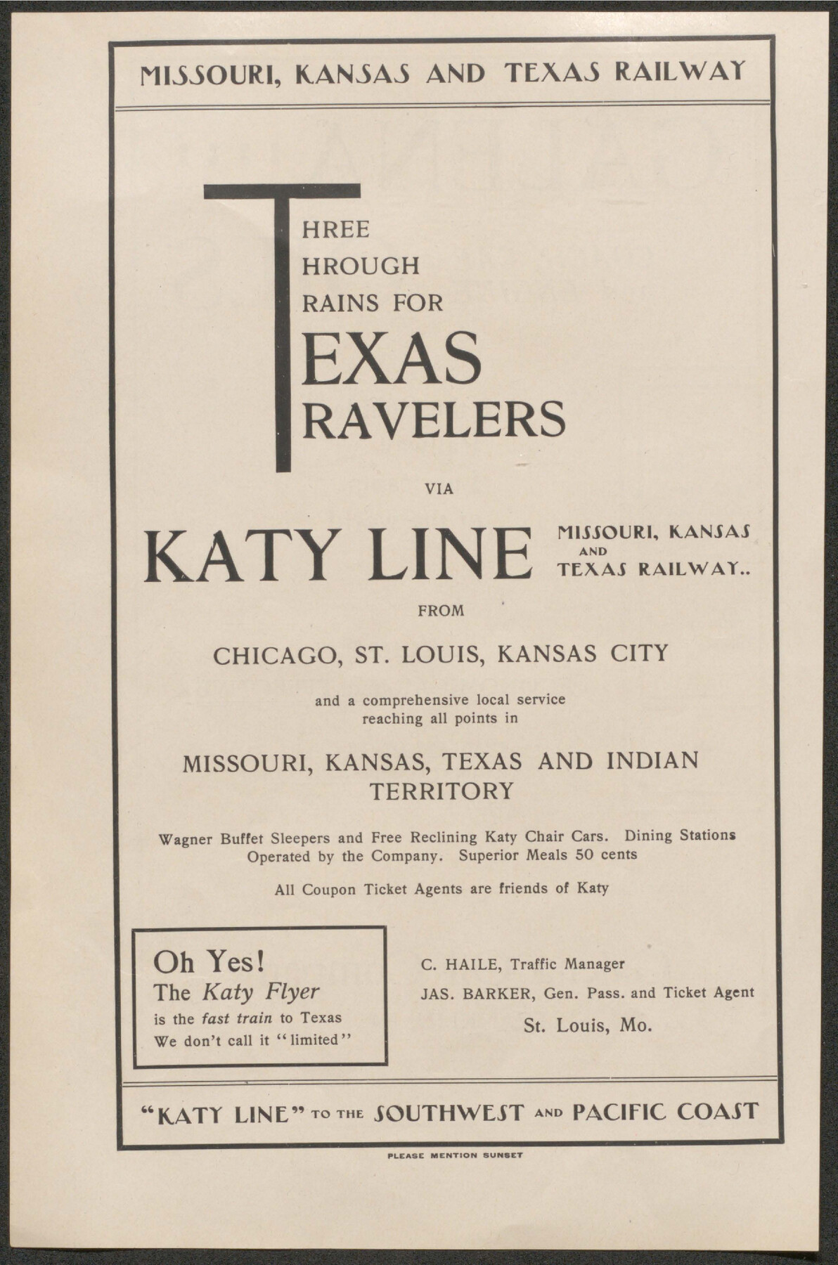
Three Through Trains for Texas Travelers via Katy Line - Missouri, Kansas and Texas Railway from Chicago, St. Louis, Kansas City and a comprehensive local service reaching all points in Missouri, Kansas, Texas and Indian Territory
-
Map/Doc
96605
-
Collection
Cobb Digital Map Collection
-
Subjects
Bound Volume Railroads
-
Height x Width
9.5 x 6.3 inches
24.1 x 16.0 cm
-
Medium
pdf
-
Comments
Courtesy of John & Diana Cobb.
Part of: Cobb Digital Map Collection

![[San Benito Promotional Booklet]](https://historictexasmaps.com/wmedia_w700/pdf_converted_jpg/qi_pdf_thumbnail_64211.jpg)
The Wonderful Lower Rio Grande Valley

Print $20.00
- Digital $50.00
The Wonderful Lower Rio Grande Valley
1909
Size 21.6 x 22.9 inches
Map/Doc 95798
Map of the Texas & Pacific Railway "Gould System" Lines and connections

Print $20.00
- Digital $50.00
Map of the Texas & Pacific Railway "Gould System" Lines and connections
1906
Size 17.7 x 36.6 inches
Map/Doc 95769
Dinsmore & Company's New and Complete Map of the Railway System of the United States and Canada compiled from official sources, under the direction of the editor of the "American Railway Guide"

Print $20.00
- Digital $50.00
Dinsmore & Company's New and Complete Map of the Railway System of the United States and Canada compiled from official sources, under the direction of the editor of the "American Railway Guide"
1855
Size 16.3 x 20.4 inches
Map/Doc 95903

Due Southwest over the Cotton Belt Route

Due Southwest over the Cotton Belt Route
1891
Map/Doc 96773
Map showing those portions of Texas traversed by Rock Island Lines and connections

Print $20.00
- Digital $50.00
Map showing those portions of Texas traversed by Rock Island Lines and connections
1904
Size 15.6 x 12.2 inches
Map/Doc 96588
Scenes Around Carrizo Springs, Texas the Hub of the Winter Garden District

Print $20.00
- Digital $50.00
Scenes Around Carrizo Springs, Texas the Hub of the Winter Garden District
1920
Size 8.8 x 15.5 inches
Map/Doc 96767
Map of the Southern Pacific Company and connections

Print $20.00
- Digital $50.00
Map of the Southern Pacific Company and connections
1890
Size 9.6 x 23.8 inches
Map/Doc 95759


You may also like
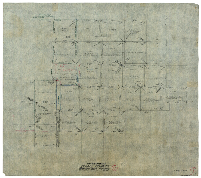
Duval County Working Sketch 9
Print $20.00
- Digital $50.00
Duval County Working Sketch 9
1935
Size 25.8 x 29.1 inches
Map/Doc 68722
A true copy of Peck's field book page 1, except classification of lands

Print $2.00
- Digital $50.00
A true copy of Peck's field book page 1, except classification of lands
1876
Size 5.3 x 12.0 inches
Map/Doc 91979
University Lands, Blocks 38 to 57, Crockett, Reagan, Irion, Schleicher Counties

Print $40.00
- Digital $50.00
University Lands, Blocks 38 to 57, Crockett, Reagan, Irion, Schleicher Counties
Size 34.0 x 53.0 inches
Map/Doc 62946
Flight Mission No. DIX-6P, Frame 121, Aransas County

Print $20.00
- Digital $50.00
Flight Mission No. DIX-6P, Frame 121, Aransas County
1956
Size 18.9 x 22.6 inches
Map/Doc 83827
Map of the Western Part of Bexar District

Print $40.00
- Digital $50.00
Map of the Western Part of Bexar District
1849
Size 64.0 x 54.3 inches
Map/Doc 16944
2008 Official Travel Map, Texas

2008 Official Travel Map, Texas
Size 33.4 x 36.5 inches
Map/Doc 94343
Post Route Map of the State of Texas, Showing Post Offices with the Intermediate Distances on Mail Routes

Print $40.00
- Digital $50.00
Post Route Map of the State of Texas, Showing Post Offices with the Intermediate Distances on Mail Routes
1908
Size 52.5 x 35.1 inches
Map/Doc 3163
Frio County Sketch File 1

Print $8.00
- Digital $50.00
Frio County Sketch File 1
1848
Size 8.6 x 7.7 inches
Map/Doc 23101
[Terry County Highways]
![92905, [Terry County Highways], Twichell Survey Records](https://historictexasmaps.com/wmedia_w700/maps/92905-1.tif.jpg)
Print $20.00
- Digital $50.00
[Terry County Highways]
Size 17.0 x 16.8 inches
Map/Doc 92905

Kimble County Sketch File A1

Print $4.00
- Digital $50.00
Kimble County Sketch File A1
Size 8.8 x 13.4 inches
Map/Doc 28961
San Patricio County Rolled Sketch 46H

Print $4.00
- Digital $50.00
San Patricio County Rolled Sketch 46H
1983
Size 12.1 x 18.4 inches
Map/Doc 8379