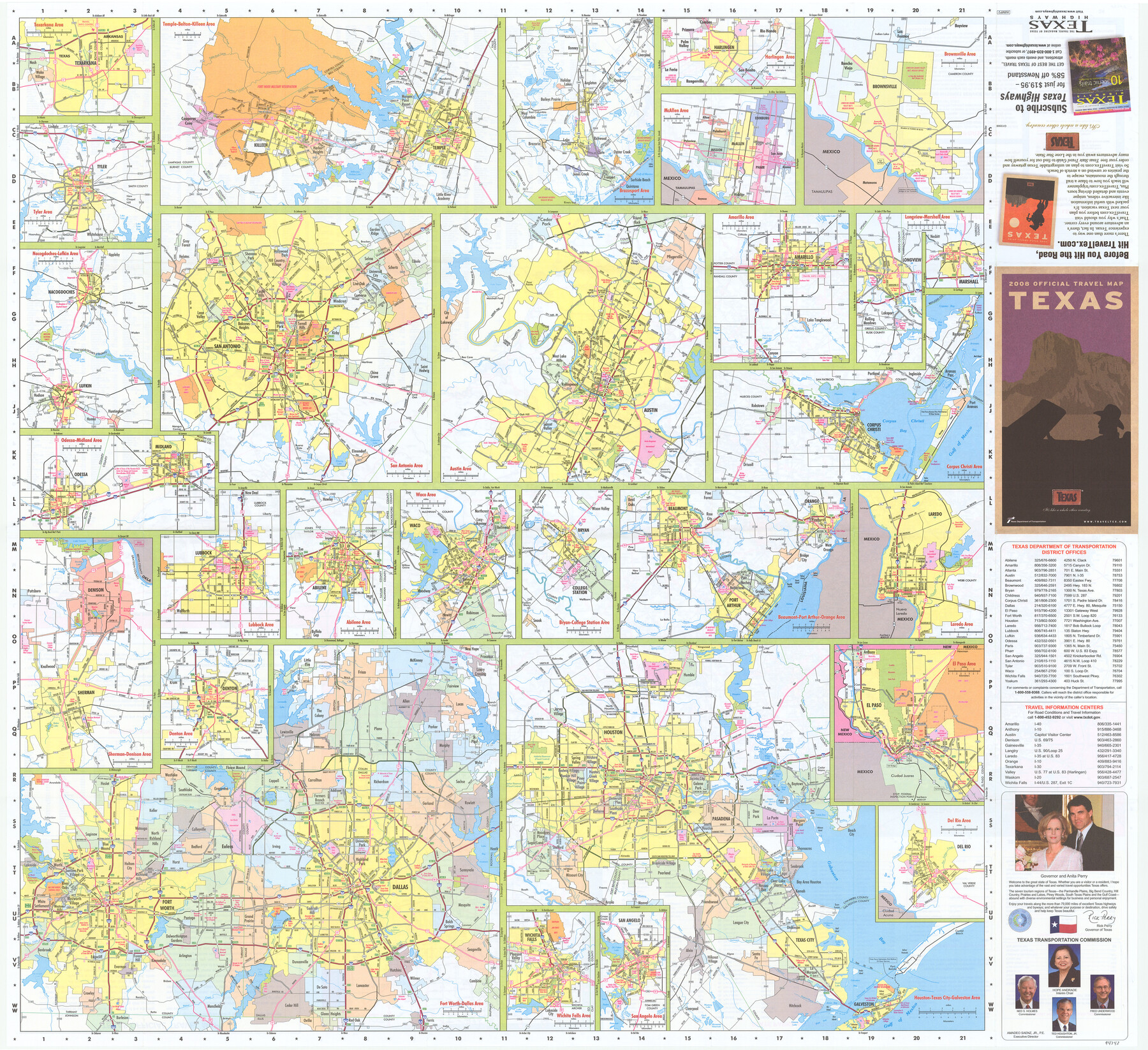
2008 Official Travel Map, Texas
[Recto - Map of various Texas cities]
-
Map/Doc
94343
-
Collection
General Map Collection
-
Object Dates
2008 (Edition Date)
-
People and Organizations
Texas Department of Transportation (Publisher)
-
Subjects
City
-
Height x Width
33.4 x 36.5 inches
84.8 x 92.7 cm
-
Medium
paper, etching/engraving/lithograph
-
Comments
For map of Texas on verso, see 94344. For research only.
Related maps
2008 Official Travel Map, Texas

2008 Official Travel Map, Texas
Size 33.5 x 36.4 inches
Map/Doc 94344
Part of: General Map Collection
Finder Map of Greater San Antonio

Print $20.00
- Digital $50.00
Finder Map of Greater San Antonio
1950
Size 28.7 x 21.4 inches
Map/Doc 94029
Pecos County Working Sketch 66

Print $20.00
- Digital $50.00
Pecos County Working Sketch 66
1955
Size 25.8 x 21.2 inches
Map/Doc 71538
Freestone County Working Sketch 31

Print $20.00
- Digital $50.00
Freestone County Working Sketch 31
1995
Size 42.8 x 33.9 inches
Map/Doc 78205
Wharton County Boundary File 1b

Print $20.00
- Digital $50.00
Wharton County Boundary File 1b
Size 15.1 x 26.6 inches
Map/Doc 59855
Maps of Gulf Intracoastal Waterway, Texas - Sabine River to the Rio Grande and connecting waterways including ship channels

Print $20.00
- Digital $50.00
Maps of Gulf Intracoastal Waterway, Texas - Sabine River to the Rio Grande and connecting waterways including ship channels
1966
Size 14.6 x 22.4 inches
Map/Doc 61953
Gregg County Rolled Sketch MHH1

Print $40.00
- Digital $50.00
Gregg County Rolled Sketch MHH1
1935
Size 167.4 x 23.1 inches
Map/Doc 9064
Webb County Sketch File 1a

Print $20.00
- Digital $50.00
Webb County Sketch File 1a
1871
Size 23.3 x 18.0 inches
Map/Doc 12623
Cooke County Boundary File 1

Print $4.00
- Digital $50.00
Cooke County Boundary File 1
Size 12.6 x 7.5 inches
Map/Doc 51826
Map of Cooke County originally Fannin Land District

Print $20.00
- Digital $50.00
Map of Cooke County originally Fannin Land District
1858
Size 25.4 x 18.9 inches
Map/Doc 950
Loving County Working Sketch 11

Print $40.00
- Digital $50.00
Loving County Working Sketch 11
1957
Size 21.2 x 120.7 inches
Map/Doc 70643
Parker County Working Sketch 27

Print $20.00
- Digital $50.00
Parker County Working Sketch 27
2009
Map/Doc 89001
Cooke County Sketch File 43

Print $28.00
- Digital $50.00
Cooke County Sketch File 43
Size 14.4 x 8.7 inches
Map/Doc 19320
You may also like

Brooks County Boundary File 1

Print $54.00
- Digital $50.00
Brooks County Boundary File 1
Size 9.0 x 8.6 inches
Map/Doc 50809
Railroad Track Map, H&TCRRCo., Falls County, Texas

Print $4.00
- Digital $50.00
Railroad Track Map, H&TCRRCo., Falls County, Texas
1918
Size 11.6 x 18.6 inches
Map/Doc 62852
General Highway Map, Kleberg County, Texas

Print $20.00
General Highway Map, Kleberg County, Texas
1940
Size 24.9 x 18.4 inches
Map/Doc 79165
[Blocks M-23, M-17, M-18, H, G, and vicinity]
![91141, [Blocks M-23, M-17, M-18, H, G, and vicinity], Twichell Survey Records](https://historictexasmaps.com/wmedia_w700/maps/91141-1.tif.jpg)
Print $20.00
- Digital $50.00
[Blocks M-23, M-17, M-18, H, G, and vicinity]
1882
Size 12.9 x 12.4 inches
Map/Doc 91141
[Surveys along the Nueces River in San Patricio County]
![69737, [Surveys along the Nueces River in San Patricio County], General Map Collection](https://historictexasmaps.com/wmedia_w700/maps/69737.tif.jpg)
Print $2.00
- Digital $50.00
[Surveys along the Nueces River in San Patricio County]
1842
Size 8.8 x 9.9 inches
Map/Doc 69737
Jack County Sketch File 16a

Print $4.00
- Digital $50.00
Jack County Sketch File 16a
1885
Size 8.3 x 11.8 inches
Map/Doc 27551
Edwards County Working Sketch 78

Print $20.00
- Digital $50.00
Edwards County Working Sketch 78
1962
Size 26.5 x 22.1 inches
Map/Doc 68954
Tyler County Sketch File 31

Print $10.00
- Digital $50.00
Tyler County Sketch File 31
1941
Size 14.3 x 9.0 inches
Map/Doc 38723
Duval County Boundary File 3

Print $14.00
- Digital $50.00
Duval County Boundary File 3
Size 8.6 x 3.9 inches
Map/Doc 52719
Map of Texas comprising the grant of the Texian Emigration and Land-Company

Print $20.00
- Digital $50.00
Map of Texas comprising the grant of the Texian Emigration and Land-Company
1843
Size 9.4 x 10.1 inches
Map/Doc 94049
Irion County Sketch File 12

Print $40.00
- Digital $50.00
Irion County Sketch File 12
1939
Size 15.3 x 12.4 inches
Map/Doc 27482