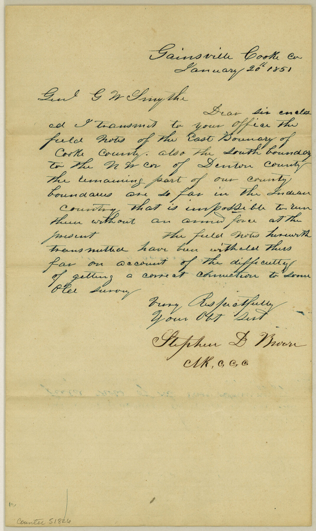
Cooke County Boundary File 1
[Letter regarding the East and South Boundary lines of Cooke County]
-
Map/Doc
51826
-
Collection
General Map Collection
-
Counties
Cooke
-
Subjects
County Boundaries
-
Height x Width
12.6 x 7.5 inches
32.0 x 19.1 cm
Part of: General Map Collection
Randall County

Print $20.00
- Digital $50.00
Randall County
1917
Size 44.7 x 36.9 inches
Map/Doc 16793
Oldham County Rolled Sketch 11

Print $40.00
- Digital $50.00
Oldham County Rolled Sketch 11
Size 48.6 x 39.9 inches
Map/Doc 10641
Map of Cherokee County

Print $40.00
- Digital $50.00
Map of Cherokee County
1933
Size 55.0 x 38.7 inches
Map/Doc 95453
East Part of Jeff Davis Co.

Print $20.00
- Digital $50.00
East Part of Jeff Davis Co.
1977
Size 46.4 x 35.7 inches
Map/Doc 73194
Tom Green County Sketch File 35

Print $6.00
- Digital $50.00
Tom Green County Sketch File 35
Size 10.2 x 15.9 inches
Map/Doc 38192
San Jacinto County Sketch File 5

Print $2.00
San Jacinto County Sketch File 5
1848
Size 8.1 x 14.5 inches
Map/Doc 35702
Controlled Mosaic by Jack Amman Photogrammetric Engineers, Inc - Sheet 5

Print $20.00
- Digital $50.00
Controlled Mosaic by Jack Amman Photogrammetric Engineers, Inc - Sheet 5
1954
Size 20.8 x 24.0 inches
Map/Doc 83449
Wood County Rolled Sketch 8

Print $20.00
- Digital $50.00
Wood County Rolled Sketch 8
1965
Size 22.6 x 34.8 inches
Map/Doc 8286
West Half of Sabine Lake, Jefferson County, showing Subdivision for Mineral Development; do not use; see Map 25a

Print $20.00
- Digital $50.00
West Half of Sabine Lake, Jefferson County, showing Subdivision for Mineral Development; do not use; see Map 25a
1956
Size 38.2 x 28.4 inches
Map/Doc 1930
Kinney County Working Sketch 49

Print $20.00
- Digital $50.00
Kinney County Working Sketch 49
1980
Size 19.9 x 25.6 inches
Map/Doc 70231
Flight Mission No. DQO-8K, Frame 44, Galveston County

Print $20.00
- Digital $50.00
Flight Mission No. DQO-8K, Frame 44, Galveston County
1952
Size 18.5 x 22.3 inches
Map/Doc 85151
[Surveys along the Nueces River in San Patricio County]
![69737, [Surveys along the Nueces River in San Patricio County], General Map Collection](https://historictexasmaps.com/wmedia_w700/maps/69737.tif.jpg)
Print $2.00
- Digital $50.00
[Surveys along the Nueces River in San Patricio County]
1842
Size 8.8 x 9.9 inches
Map/Doc 69737
You may also like
Crane County Working Sketch 29

Print $20.00
- Digital $50.00
Crane County Working Sketch 29
1976
Size 45.4 x 36.5 inches
Map/Doc 68306

Crosby County Working Sketch 2

Print $20.00
- Digital $50.00
Crosby County Working Sketch 2
Size 18.2 x 18.0 inches
Map/Doc 68436
Liberty County

Print $20.00
- Digital $50.00
Liberty County
1882
Size 26.1 x 24.8 inches
Map/Doc 3813
Coleman County Working Sketch 20

Print $20.00
- Digital $50.00
Coleman County Working Sketch 20
1953
Size 32.7 x 41.9 inches
Map/Doc 68086
Cass County Working Sketch 31

Print $20.00
- Digital $50.00
Cass County Working Sketch 31
1981
Size 30.7 x 31.1 inches
Map/Doc 67934
Houston County State Real Property Sketch 1

Print $20.00
- Digital $50.00
Houston County State Real Property Sketch 1
1997
Size 35.5 x 24.4 inches
Map/Doc 80129
Stonewall County Sketch File 7

Print $24.00
- Digital $50.00
Stonewall County Sketch File 7
1896
Size 11.4 x 7.4 inches
Map/Doc 37213
[PSL Block 1 along State line]
![90579, [PSL Block 1 along State line], Twichell Survey Records](https://historictexasmaps.com/wmedia_w700/maps/90579-1.tif.jpg)
Print $2.00
- Digital $50.00
[PSL Block 1 along State line]
Size 14.1 x 8.0 inches
Map/Doc 90579
Liberty County Sketch File 67

Print $28.00
- Digital $50.00
Liberty County Sketch File 67
1996
Size 11.3 x 8.8 inches
Map/Doc 30135
Flight Mission No. DAG-14K, Frame 146, Matagorda County

Print $20.00
- Digital $50.00
Flight Mission No. DAG-14K, Frame 146, Matagorda County
1952
Size 18.4 x 22.2 inches
Map/Doc 86313
Tyler County Rolled Sketch 8

Print $20.00
- Digital $50.00
Tyler County Rolled Sketch 8
1965
Size 18.1 x 25.4 inches
Map/Doc 8058