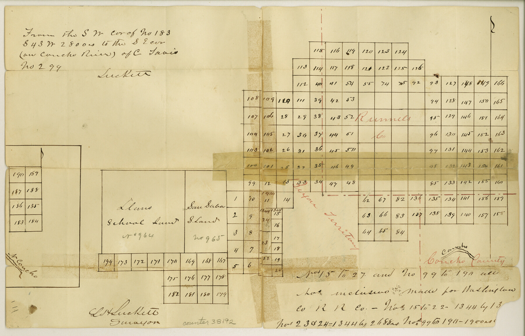
Tom Green County Sketch File 35
[Sketch of large area north of the Concho River north and east from San Angelo]
-
Map/Doc
38192
-
Collection
General Map Collection
-
Object Dates
9/8/1873 (File Date)
-
People and Organizations
L.H. Luckett (Surveyor/Engineer)
-
Counties
Tom Green Concho Runnels
-
Subjects
Surveying Sketch File
-
Height x Width
10.2 x 15.9 inches
25.9 x 40.4 cm
-
Medium
paper, manuscript
-
Features
Concho River
North Concho River
Part of: General Map Collection
Archer County Rolled Sketch 10

Print $20.00
- Digital $50.00
Archer County Rolled Sketch 10
2012
Size 19.2 x 24.6 inches
Map/Doc 93326
Grayson County Working Sketch 23

Print $20.00
- Digital $50.00
Grayson County Working Sketch 23
1976
Size 18.6 x 24.3 inches
Map/Doc 63262
Dallam County Sketch File 14

Print $4.00
- Digital $50.00
Dallam County Sketch File 14
1949
Size 11.3 x 8.8 inches
Map/Doc 20379
Wise County Sketch File 53

Print $12.00
- Digital $50.00
Wise County Sketch File 53
2007
Size 8.5 x 14.0 inches
Map/Doc 87360
Kendall County Sketch File 1

Print $4.00
- Digital $50.00
Kendall County Sketch File 1
Size 9.6 x 8.3 inches
Map/Doc 28671
Lipscomb County Working Sketch 3

Print $20.00
- Digital $50.00
Lipscomb County Working Sketch 3
1965
Size 27.8 x 46.1 inches
Map/Doc 70579
Flight Mission No. DQN-5K, Frame 31, Calhoun County

Print $20.00
- Digital $50.00
Flight Mission No. DQN-5K, Frame 31, Calhoun County
1953
Size 18.5 x 22.1 inches
Map/Doc 84382
Flight Mission No. BQR-9K, Frame 42, Brazoria County

Print $20.00
- Digital $50.00
Flight Mission No. BQR-9K, Frame 42, Brazoria County
1952
Size 18.6 x 22.2 inches
Map/Doc 84046
Concho County Sketch File 1

Print $5.00
- Digital $50.00
Concho County Sketch File 1
1856
Size 5.0 x 6.6 inches
Map/Doc 19121
Erath County Rolled Sketch 6

Print $20.00
- Digital $50.00
Erath County Rolled Sketch 6
Size 36.8 x 27.0 inches
Map/Doc 5867
Map of Limestone County

Print $20.00
- Digital $50.00
Map of Limestone County
1858
Size 23.2 x 23.8 inches
Map/Doc 3819
Fannin County Rolled Sketch 18B

Print $20.00
- Digital $50.00
Fannin County Rolled Sketch 18B
Size 12.7 x 16.1 inches
Map/Doc 5869
You may also like
Orange County Sketch File 34

Print $20.00
- Digital $50.00
Orange County Sketch File 34
1929
Size 23.5 x 27.7 inches
Map/Doc 12126
G. C. & S. F. Ry., San Saba Branch, Texas, Right of Way Map, Hall to Brady

Print $40.00
- Digital $50.00
G. C. & S. F. Ry., San Saba Branch, Texas, Right of Way Map, Hall to Brady
1916
Size 38.9 x 124.3 inches
Map/Doc 61418
Sherman County Rolled Sketch 7

Print $20.00
- Digital $50.00
Sherman County Rolled Sketch 7
1919
Size 32.7 x 19.0 inches
Map/Doc 7787
Fort Bend County Working Sketch 5

Print $20.00
- Digital $50.00
Fort Bend County Working Sketch 5
1915
Size 14.5 x 20.9 inches
Map/Doc 69211
Stonewall County

Print $40.00
- Digital $50.00
Stonewall County
1888
Size 56.1 x 55.2 inches
Map/Doc 89056
[Sketch for Mineral Application 27669 - Trinity River, Frank R. Graves]
![2860, [Sketch for Mineral Application 27669 - Trinity River, Frank R. Graves], General Map Collection](https://historictexasmaps.com/wmedia_w700/maps/2860-1.tif.jpg)
Print $20.00
- Digital $50.00
[Sketch for Mineral Application 27669 - Trinity River, Frank R. Graves]
1934
Size 27.4 x 42.7 inches
Map/Doc 2860
Culberson County Working Sketch 45

Print $20.00
- Digital $50.00
Culberson County Working Sketch 45
1971
Size 24.4 x 37.1 inches
Map/Doc 68499
Upshur County Sketch File 11

Print $22.00
- Digital $50.00
Upshur County Sketch File 11
Size 8.4 x 10.4 inches
Map/Doc 38750
Blanco County Rolled Sketch 21

Print $20.00
- Digital $50.00
Blanco County Rolled Sketch 21
2007
Size 18.1 x 13.0 inches
Map/Doc 87925

The Republic County of Harrison. Created, January 28, 1839

Print $20.00
The Republic County of Harrison. Created, January 28, 1839
2020
Size 18.6 x 21.7 inches
Map/Doc 96169
Blanco County Working Sketch 17

Print $20.00
- Digital $50.00
Blanco County Working Sketch 17
1954
Size 31.6 x 30.3 inches
Map/Doc 67377