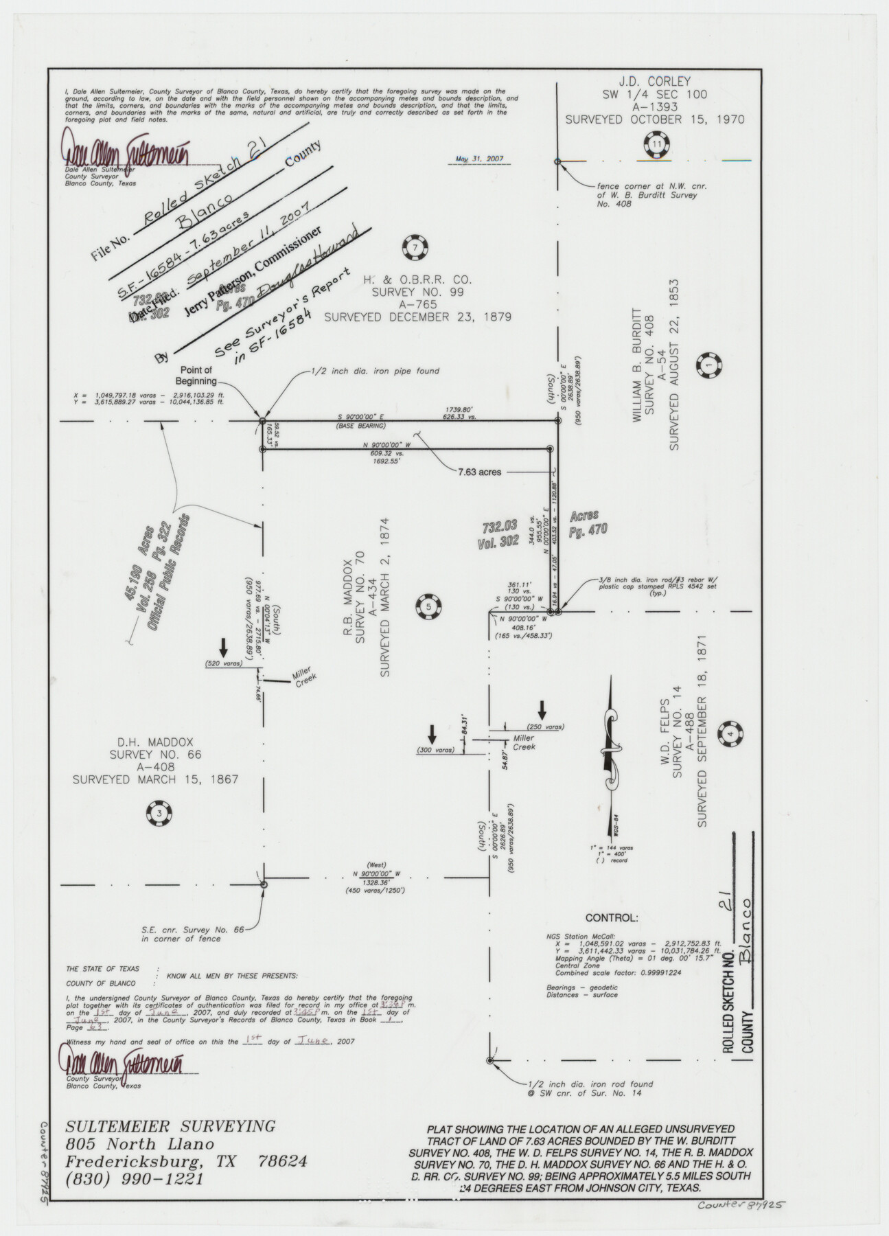
Blanco County Rolled Sketch 21
Plat showing the location of an alleged unsurveyed tract of land of 7.63 acres bounded by the W. Burditt survey no. 408, the W.D. Felps survey no. 14, the R.B. Maddox survey no. 70, the D.H. Maddox survey no. 66 and the H. & O. B. R.R. Co. survey no. 99
-
Map/Doc
87925
-
Collection
General Map Collection
-
Object Dates
2007/5/31 (Creation Date)
2007/9/11 (File Date)
-
People and Organizations
Dale Allen Sultemeier (Surveyor/Engineer)
-
Counties
Blanco
-
Subjects
Surveying Rolled Sketch
-
Height x Width
18.1 x 13.0 inches
46.0 x 33.0 cm
-
Medium
mylar, print
-
Scale
1" = 144 varas = 400 feet
-
Comments
See surveyor's report in SF-16584.
Part of: General Map Collection
Knox County Working Sketch 20

Print $20.00
- Digital $50.00
Knox County Working Sketch 20
2012
Size 40.2 x 36.9 inches
Map/Doc 93389
[The S.K. Ry. of Texas, State Line to Pecos, Reeves Co., Texas]
![64162, [The S.K. Ry. of Texas, State Line to Pecos, Reeves Co., Texas], General Map Collection](https://historictexasmaps.com/wmedia_w700/maps/64162.tif.jpg)
Print $40.00
- Digital $50.00
[The S.K. Ry. of Texas, State Line to Pecos, Reeves Co., Texas]
1910
Size 19.8 x 120.7 inches
Map/Doc 64162
Terrell County Rolled Sketch 53

Print $20.00
- Digital $50.00
Terrell County Rolled Sketch 53
Size 33.1 x 24.2 inches
Map/Doc 7971
Erath County Working Sketch 43

Print $20.00
- Digital $50.00
Erath County Working Sketch 43
1981
Size 19.6 x 15.7 inches
Map/Doc 69124
Hemphill County Sketch File 6

Print $8.00
- Digital $50.00
Hemphill County Sketch File 6
1902
Size 14.2 x 8.6 inches
Map/Doc 26299
Bandera County Sketch File 20

Print $40.00
- Digital $50.00
Bandera County Sketch File 20
Size 18.7 x 13.6 inches
Map/Doc 10894
Brewster County Sketch File N-8

Print $12.00
- Digital $50.00
Brewster County Sketch File N-8
1914
Size 10.8 x 8.6 inches
Map/Doc 15610
McLennan County Sketch File 18

Print $8.00
- Digital $50.00
McLennan County Sketch File 18
1880
Size 12.8 x 8.3 inches
Map/Doc 31280
Intracoastal Waterway, Houma, LA to Corpus Christi, TX

Print $20.00
- Digital $50.00
Intracoastal Waterway, Houma, LA to Corpus Christi, TX
Size 26.6 x 20.8 inches
Map/Doc 61907
Polk County Working Sketch 3

Print $40.00
- Digital $50.00
Polk County Working Sketch 3
1911
Size 25.4 x 56.0 inches
Map/Doc 71618
Flight Mission No. BRA-7M, Frame 203, Jefferson County

Print $20.00
- Digital $50.00
Flight Mission No. BRA-7M, Frame 203, Jefferson County
1953
Size 18.6 x 22.3 inches
Map/Doc 85571
Eastland County Rolled Sketch B

Print $20.00
- Digital $50.00
Eastland County Rolled Sketch B
1893
Size 27.7 x 40.9 inches
Map/Doc 5774
You may also like
Brewster County Rolled Sketch 123

Print $25.00
- Digital $50.00
Brewster County Rolled Sketch 123
Size 10.1 x 15.3 inches
Map/Doc 43129
Moore County Sketch File 5

Print $22.00
- Digital $50.00
Moore County Sketch File 5
Size 9.0 x 12.6 inches
Map/Doc 31937
Wichita County Working Sketch 1

Print $20.00
- Digital $50.00
Wichita County Working Sketch 1
Size 23.5 x 24.2 inches
Map/Doc 72510
Nueces County Rolled Sketch 11

Print $40.00
- Digital $50.00
Nueces County Rolled Sketch 11
Size 43.2 x 56.8 inches
Map/Doc 9586
Gillespie County Boundary File 1

Print $30.00
- Digital $50.00
Gillespie County Boundary File 1
Size 8.5 x 3.8 inches
Map/Doc 53709
Presidio County Working Sketch 58

Print $20.00
- Digital $50.00
Presidio County Working Sketch 58
1956
Size 21.9 x 24.2 inches
Map/Doc 71735
Palo Pinto County Sketch File 6a

Print $20.00
- Digital $50.00
Palo Pinto County Sketch File 6a
Size 37.8 x 38.6 inches
Map/Doc 10565
Flight Mission No. DQN-1K, Frame 35, Calhoun County

Print $20.00
- Digital $50.00
Flight Mission No. DQN-1K, Frame 35, Calhoun County
1953
Size 18.5 x 19.0 inches
Map/Doc 84140
General Highway Map, McLennan County, Texas

Print $20.00
General Highway Map, McLennan County, Texas
1940
Size 18.3 x 24.6 inches
Map/Doc 79191
Flight Mission No. DCL-7C, Frame 113, Kenedy County

Print $20.00
- Digital $50.00
Flight Mission No. DCL-7C, Frame 113, Kenedy County
1943
Size 18.5 x 22.2 inches
Map/Doc 86078
Brooks County Sketch File 7

Print $10.00
- Digital $50.00
Brooks County Sketch File 7
1946
Size 11.3 x 8.6 inches
Map/Doc 16566
