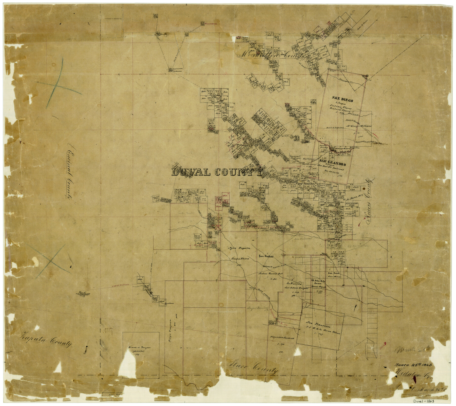
Duval County
-
Map/Doc
3497
-
Collection
General Map Collection
-
Object Dates
3/25/1863 (Creation Date)
-
Counties
Duval
-
Subjects
County
-
Height x Width
27.0 x 30.5 inches
68.6 x 77.5 cm
-
Features
L. de Santa Alejandra Hill
Laredo Road
Agua Poquita Creek
Vales Rancho
Los Indios Rancho
Charco Valiente
Jabonilla
La Vendria
Las Encinas
L. de Santa Teresa Hill
La Baronena Creek
Resaca de Eumedio Creek
Santa Maria River
Derramadera de las Anaquitas Creek
San Ramigio
San Leandro
Las Jaboncillas
Charco Puerco Lake
Alletca de los Angeles Creek
Tarancahuas Creek
Botello Creek
Amargosa Creek
Chiltipin Creek
Muerto Creek
San Diego Creek
Collins Creek
Las Animas Creek
San Juan Creek
West Chiltipin Creek
Las Prietas Creek
San Diego
Road to Eagle Pass
Narciseno Creek
Parrilla Creek
Piedras Pintas Creek
Trinidad Creek
Laguna Travesada
Part of: General Map Collection
Motley County Sketch File 3A (N)

Print $20.00
- Digital $50.00
Motley County Sketch File 3A (N)
Size 12.3 x 17.5 inches
Map/Doc 42136
Runnels County Working Sketch 30a

Print $20.00
- Digital $50.00
Runnels County Working Sketch 30a
1959
Size 23.3 x 25.4 inches
Map/Doc 63626
Nacogdoches County Sketch File 14

Print $42.00
- Digital $50.00
Nacogdoches County Sketch File 14
1926
Size 8.8 x 11.3 inches
Map/Doc 32259
[Sketch for Mineral Application 19560 - 19588 - San Bernard River]
![65661, [Sketch for Mineral Application 19560 - 19588 - San Bernard River], General Map Collection](https://historictexasmaps.com/wmedia_w700/maps/65661.tif.jpg)
Print $40.00
- Digital $50.00
[Sketch for Mineral Application 19560 - 19588 - San Bernard River]
Size 32.3 x 98.5 inches
Map/Doc 65661
Culberson County Working Sketch 60

Print $40.00
- Digital $50.00
Culberson County Working Sketch 60
1974
Size 74.7 x 32.7 inches
Map/Doc 68514
Nolan County Sketch File 17

Print $6.00
- Digital $50.00
Nolan County Sketch File 17
1940
Size 17.9 x 10.1 inches
Map/Doc 32487
Crockett County

Print $40.00
- Digital $50.00
Crockett County
1882
Size 57.6 x 31.6 inches
Map/Doc 88865
North Shore of West Bay and Galveston Island

Print $40.00
- Digital $50.00
North Shore of West Bay and Galveston Island
1933
Size 37.4 x 57.7 inches
Map/Doc 69930
La Salle County Rolled Sketch 16

Print $20.00
- Digital $50.00
La Salle County Rolled Sketch 16
1948
Size 26.7 x 20.9 inches
Map/Doc 6580
Hays County Rolled Sketch 33

Print $20.00
- Digital $50.00
Hays County Rolled Sketch 33
Size 15.4 x 19.1 inches
Map/Doc 89012
Hardin County Sketch File 66

Print $20.00
- Digital $50.00
Hardin County Sketch File 66
1948
Size 19.5 x 35.8 inches
Map/Doc 11639
Webb County Rolled Sketch 77

Print $20.00
- Digital $50.00
Webb County Rolled Sketch 77
1980
Size 39.1 x 38.5 inches
Map/Doc 10134
You may also like
Randall County Rolled Sketch 10

Print $20.00
- Digital $50.00
Randall County Rolled Sketch 10
Size 26.9 x 22.6 inches
Map/Doc 7431
Gonzales County Working Sketch 3

Print $20.00
- Digital $50.00
Gonzales County Working Sketch 3
1943
Size 37.8 x 41.5 inches
Map/Doc 63218
Current Miscellaneous File 35

Print $10.00
- Digital $50.00
Current Miscellaneous File 35
Size 14.2 x 8.7 inches
Map/Doc 73947
Blanco County Working Sketch 43

Print $20.00
- Digital $50.00
Blanco County Working Sketch 43
1993
Size 42.7 x 26.5 inches
Map/Doc 67403
Archer County Working Sketch 22

Print $20.00
- Digital $50.00
Archer County Working Sketch 22
1980
Size 36.4 x 38.0 inches
Map/Doc 67163
Reeves County Working Sketch 55

Print $20.00
- Digital $50.00
Reeves County Working Sketch 55
1978
Size 36.1 x 34.7 inches
Map/Doc 63498

General Highway Map, Wheeler County, Texas

Print $20.00
General Highway Map, Wheeler County, Texas
1961
Size 18.1 x 24.9 inches
Map/Doc 79708
Upton County Working Sketch 33

Print $20.00
- Digital $50.00
Upton County Working Sketch 33
1955
Size 17.9 x 37.8 inches
Map/Doc 69529
Andrews County Rolled Sketch 6

Print $40.00
- Digital $50.00
Andrews County Rolled Sketch 6
1928
Size 43.9 x 56.9 inches
Map/Doc 8363
[Surveys in Austin's Colony along the Navidad River, Caney Fork, and upper Rocky Creek]
![201, [Surveys in Austin's Colony along the Navidad River, Caney Fork, and upper Rocky Creek], General Map Collection](https://historictexasmaps.com/wmedia_w700/maps/201-1.tif.jpg)
Print $20.00
- Digital $50.00
[Surveys in Austin's Colony along the Navidad River, Caney Fork, and upper Rocky Creek]
1831
Size 20.5 x 26.7 inches
Map/Doc 201
Matagorda County Sketch File 30

Print $20.00
- Digital $50.00
Matagorda County Sketch File 30
1911
Size 22.2 x 31.9 inches
Map/Doc 12045