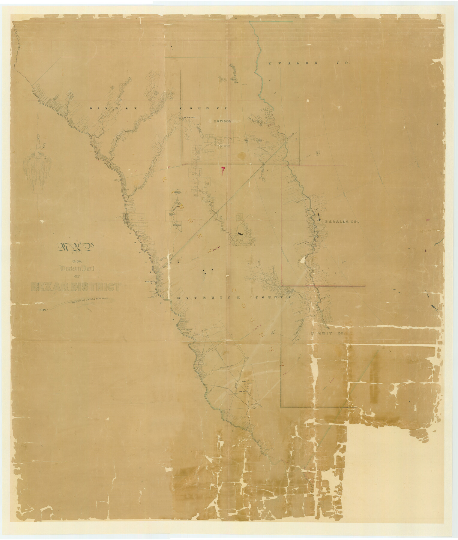
Map of the Western Part of Bexar District
-
Map/Doc
16944
-
Collection
General Map Collection
-
Object Dates
1849 (Creation Date)
-
People and Organizations
General Land Office (Publisher)
John Mahoney (?) (Draftsman)
-
Counties
Kinney Maverick Dimmit Zavala
-
Subjects
District
-
Height x Width
64.0 x 54.3 inches
162.6 x 137.9 cm
-
Comments
Digitally recombined image. Conservation funded in two pieces: see 87375 for the west part, and 87376 for the east part.
Part of: General Map Collection
[Beaumont, Sour Lake and Western Ry. Right of Way and Alignment - Frisco]
![64111, [Beaumont, Sour Lake and Western Ry. Right of Way and Alignment - Frisco], General Map Collection](https://historictexasmaps.com/wmedia_w700/maps/64111.tif.jpg)
Print $20.00
- Digital $50.00
[Beaumont, Sour Lake and Western Ry. Right of Way and Alignment - Frisco]
1910
Size 19.8 x 45.9 inches
Map/Doc 64111
Red River County Working Sketch 49

Print $20.00
- Digital $50.00
Red River County Working Sketch 49
1970
Size 31.3 x 21.5 inches
Map/Doc 72032
Fannin County Rolled Sketch 18G

Print $20.00
- Digital $50.00
Fannin County Rolled Sketch 18G
Size 27.9 x 36.0 inches
Map/Doc 5874
Kenedy County Boundary File 2a

Print $22.00
- Digital $50.00
Kenedy County Boundary File 2a
Size 14.7 x 40.9 inches
Map/Doc 55793
Comanche County Working Sketch 30

Print $20.00
- Digital $50.00
Comanche County Working Sketch 30
1988
Size 18.8 x 28.2 inches
Map/Doc 68164
Padre Island National Seashore

Print $4.00
- Digital $50.00
Padre Island National Seashore
Size 15.9 x 22.3 inches
Map/Doc 60539
Anderson County Sketch File 12

Print $6.00
- Digital $50.00
Anderson County Sketch File 12
1852
Size 13.7 x 8.3 inches
Map/Doc 12771
Flight Mission No. BRA-7M, Frame 138, Jefferson County

Print $20.00
- Digital $50.00
Flight Mission No. BRA-7M, Frame 138, Jefferson County
1953
Size 18.6 x 22.4 inches
Map/Doc 85532
Stephens County Boundary File 6

Print $12.00
- Digital $50.00
Stephens County Boundary File 6
Size 13.0 x 8.5 inches
Map/Doc 58901
Sketch of surveys in Harrison & Marion Cos. showing Caddo Lake & Subdivisions

Print $5.00
- Digital $50.00
Sketch of surveys in Harrison & Marion Cos. showing Caddo Lake & Subdivisions
1955
Size 32.6 x 32.5 inches
Map/Doc 2895
Cooke County Working Sketch 32

Print $20.00
- Digital $50.00
Cooke County Working Sketch 32
1982
Size 19.0 x 14.8 inches
Map/Doc 68269
Dallas County Boundary File 3

Print $6.00
- Digital $50.00
Dallas County Boundary File 3
Size 14.2 x 8.6 inches
Map/Doc 52120
You may also like
General Highway Map, Denton County, Texas

Print $20.00
General Highway Map, Denton County, Texas
1939
Size 18.5 x 25.3 inches
Map/Doc 79074
Hunt County Sketch File 27

Print $4.00
- Digital $50.00
Hunt County Sketch File 27
1860
Size 10.3 x 7.6 inches
Map/Doc 27126
Jefferson County Rolled Sketch 67

Print $20.00
- Digital $50.00
Jefferson County Rolled Sketch 67
2007
Size 21.1 x 23.6 inches
Map/Doc 93426
[Blocks 57, 56, 55, 54, 76, 53]
![92928, [Blocks 57, 56, 55, 54, 76, 53], Twichell Survey Records](https://historictexasmaps.com/wmedia_w700/maps/92928-1.tif.jpg)
Print $20.00
- Digital $50.00
[Blocks 57, 56, 55, 54, 76, 53]
Size 36.6 x 23.1 inches
Map/Doc 92928
[Center Line of the Texas and Pacific Railroad Company 16 Mile Reserve]
![3125, [Center Line of the Texas and Pacific Railroad Company 16 Mile Reserve], General Map Collection](https://historictexasmaps.com/wmedia_w700/maps/3125-1.tif.jpg)
Print $40.00
- Digital $50.00
[Center Line of the Texas and Pacific Railroad Company 16 Mile Reserve]
1876
Size 43.1 x 55.6 inches
Map/Doc 3125
Brooks County Working Sketch 3

Print $20.00
- Digital $50.00
Brooks County Working Sketch 3
Size 16.2 x 21.3 inches
Map/Doc 67787
Montgomery County Working Sketch 19

Print $20.00
- Digital $50.00
Montgomery County Working Sketch 19
1935
Size 31.8 x 36.6 inches
Map/Doc 71126
Map Showing Lands Surveyed for Tom Pinkston, W. D. Twichell and H. Y. Quarles in Stephens County, Texas

Print $20.00
- Digital $50.00
Map Showing Lands Surveyed for Tom Pinkston, W. D. Twichell and H. Y. Quarles in Stephens County, Texas
1919
Size 19.7 x 21.2 inches
Map/Doc 91892

Map of a part of Laguna Madre showing subdivision for mineral development

Print $40.00
- Digital $50.00
Map of a part of Laguna Madre showing subdivision for mineral development
1963
Size 68.1 x 46.0 inches
Map/Doc 2916
Flight Mission No. DQN-1K, Frame 121, Calhoun County

Print $20.00
- Digital $50.00
Flight Mission No. DQN-1K, Frame 121, Calhoun County
1953
Size 18.6 x 22.2 inches
Map/Doc 84187
Jackson County Working Sketch 12

Print $20.00
- Digital $50.00
Jackson County Working Sketch 12
Size 31.2 x 33.0 inches
Map/Doc 66460