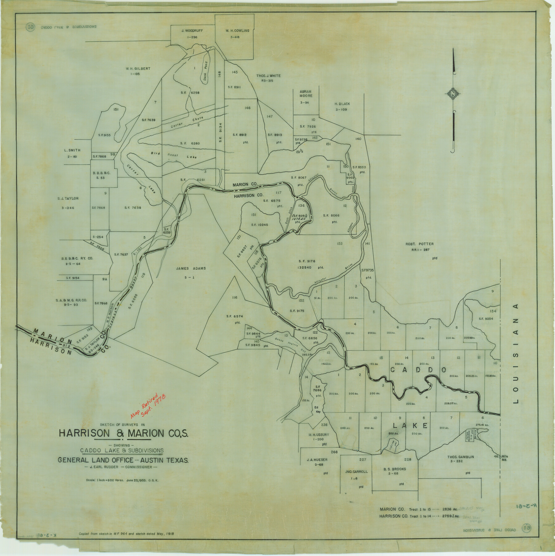
Sketch of surveys in Harrison & Marion Cos. showing Caddo Lake & Subdivisions
K-3-61
-
Map/Doc
2895
-
Collection
General Map Collection
-
Object Dates
1955 (Creation Date)
-
People and Organizations
General Land Office (Publisher)
-
Counties
Harrison Marion
-
Height x Width
32.6 x 32.5 inches
82.8 x 82.6 cm
-
Comments
Map retired in Sept. 1978.
Part of: General Map Collection
Kimble County Sketch File A1

Print $4.00
- Digital $50.00
Kimble County Sketch File A1
Size 8.8 x 13.4 inches
Map/Doc 28961
Carte de la Louisiane et du Cours du Mississipi

Print $20.00
- Digital $50.00
Carte de la Louisiane et du Cours du Mississipi
1718
Size 21.7 x 28.6 inches
Map/Doc 95161
Glasscock County Rolled Sketch 17

Print $20.00
- Digital $50.00
Glasscock County Rolled Sketch 17
Size 21.6 x 27.4 inches
Map/Doc 6021
Flight Mission No. BQR-20K, Frame 7, Brazoria County

Print $20.00
- Digital $50.00
Flight Mission No. BQR-20K, Frame 7, Brazoria County
1952
Size 18.6 x 22.4 inches
Map/Doc 84109
Map of Refugio County

Print $20.00
- Digital $50.00
Map of Refugio County
1885
Size 19.8 x 25.9 inches
Map/Doc 3986
Brewster County Rolled Sketch 110

Print $20.00
- Digital $50.00
Brewster County Rolled Sketch 110
1961
Size 19.7 x 37.7 inches
Map/Doc 5262
Flight Mission No. DIX-10P, Frame 152, Aransas County

Print $20.00
- Digital $50.00
Flight Mission No. DIX-10P, Frame 152, Aransas County
1956
Size 18.6 x 22.2 inches
Map/Doc 83954
Flight Mission No. CGI-3N, Frame 187, Cameron County

Print $20.00
- Digital $50.00
Flight Mission No. CGI-3N, Frame 187, Cameron County
1954
Size 18.5 x 22.2 inches
Map/Doc 84651
Culberson County Rolled Sketch 41

Print $88.00
- Digital $50.00
Culberson County Rolled Sketch 41
1944
Size 57.5 x 46.0 inches
Map/Doc 8752
Rains County Working Sketch 3

Print $20.00
- Digital $50.00
Rains County Working Sketch 3
1918
Size 22.3 x 12.5 inches
Map/Doc 71829
Terrell County Working Sketch 69

Print $20.00
- Digital $50.00
Terrell County Working Sketch 69
1978
Size 28.0 x 32.7 inches
Map/Doc 69590
Flight Mission No. DQO-2K, Frame 145, Galveston County

Print $20.00
- Digital $50.00
Flight Mission No. DQO-2K, Frame 145, Galveston County
1952
Size 18.8 x 22.5 inches
Map/Doc 85042
You may also like
McMullen County Working Sketch 30

Print $40.00
- Digital $50.00
McMullen County Working Sketch 30
1957
Size 41.4 x 50.8 inches
Map/Doc 70731
[Movements & Objectives of the 143rd & 144th Infantry on October 13, 1918, Appendix L]
![94124, [Movements & Objectives of the 143rd & 144th Infantry on October 13, 1918, Appendix L], Non-GLO Digital Images](https://historictexasmaps.com/wmedia_w700/maps/94124-1.tif.jpg)
Print $20.00
[Movements & Objectives of the 143rd & 144th Infantry on October 13, 1918, Appendix L]
1918
Size 16.1 x 16.8 inches
Map/Doc 94124
Jack County Boundary File 3b

Print $23.00
- Digital $50.00
Jack County Boundary File 3b
Size 15.6 x 38.4 inches
Map/Doc 55418
Township No. 1 South Range No. 20 West of the Indian Meridian

Print $20.00
- Digital $50.00
Township No. 1 South Range No. 20 West of the Indian Meridian
1875
Size 19.3 x 24.4 inches
Map/Doc 75179
Flight Mission No. DCL-7C, Frame 54, Kenedy County

Print $20.00
- Digital $50.00
Flight Mission No. DCL-7C, Frame 54, Kenedy County
1943
Size 15.3 x 15.3 inches
Map/Doc 86042
Wood County Rolled Sketch 4

Print $20.00
- Digital $50.00
Wood County Rolled Sketch 4
1943
Size 37.0 x 29.2 inches
Map/Doc 8283
Map of Asia engraved to illustrate Mitchell's new intermediate geography (Inset: Map of Palestine or the Holy Land)

Print $20.00
- Digital $50.00
Map of Asia engraved to illustrate Mitchell's new intermediate geography (Inset: Map of Palestine or the Holy Land)
1885
Size 9.0 x 12.2 inches
Map/Doc 93529
Gillespie County

Print $40.00
- Digital $50.00
Gillespie County
1887
Size 34.6 x 49.8 inches
Map/Doc 66836
Gray County Sketch File 7c

Print $20.00
- Digital $50.00
Gray County Sketch File 7c
1885
Size 26.5 x 19.6 inches
Map/Doc 11576
Donley County Rolled Sketch 3A

Print $20.00
- Digital $50.00
Donley County Rolled Sketch 3A
1946
Size 15.2 x 22.6 inches
Map/Doc 5730
Hunt County Sketch File 39

Print $8.00
- Digital $50.00
Hunt County Sketch File 39
1922
Size 14.3 x 8.8 inches
Map/Doc 27159
City of Austin, Texas and Suburban Areas

Print $40.00
- Digital $50.00
City of Austin, Texas and Suburban Areas
1964
Size 48.3 x 34.4 inches
Map/Doc 73563