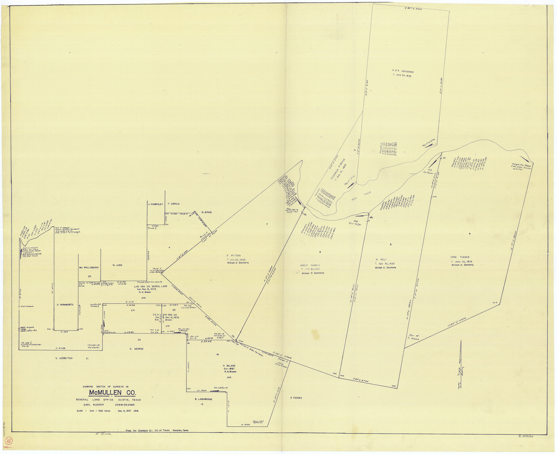
McMullen County Working Sketch 30
-
Map/Doc
70731
-
Collection
General Map Collection
-
Object Dates
12/6/1957 (Creation Date)
-
Counties
McMullen
-
Subjects
Surveying Working Sketch
-
Height x Width
41.4 x 50.8 inches
105.2 x 129.0 cm
-
Scale
1" = 500 varas
Part of: General Map Collection
Gray County Rolled Sketch A

Print $20.00
- Digital $50.00
Gray County Rolled Sketch A
1888
Size 40.4 x 40.8 inches
Map/Doc 9008
Austin County

Print $20.00
- Digital $50.00
Austin County
1943
Size 38.5 x 41.3 inches
Map/Doc 77205
Jefferson Co.

Print $20.00
- Digital $50.00
Jefferson Co.
1918
Size 46.7 x 40.8 inches
Map/Doc 16860
Hutchinson County Working Sketch 46

Print $20.00
- Digital $50.00
Hutchinson County Working Sketch 46
1979
Size 20.4 x 22.3 inches
Map/Doc 66406
Brewster County Rolled Sketch 11A

Print $20.00
- Digital $50.00
Brewster County Rolled Sketch 11A
1881
Size 24.9 x 23.0 inches
Map/Doc 5192
Johnson County Boundary File 51b

Print $80.00
- Digital $50.00
Johnson County Boundary File 51b
Size 53.9 x 9.4 inches
Map/Doc 55619
Refugio County Sketch File 14

Print $2.00
- Digital $50.00
Refugio County Sketch File 14
Size 12.8 x 8.1 inches
Map/Doc 35267
Bexar County Sketch File 30

Print $8.00
- Digital $50.00
Bexar County Sketch File 30
1867
Size 9.5 x 8.2 inches
Map/Doc 14492
Presidio County Rolled Sketch 143

Print $20.00
- Digital $50.00
Presidio County Rolled Sketch 143
Size 40.2 x 36.8 inches
Map/Doc 90046

Polk County Sketch File 9

Print $28.00
- Digital $50.00
Polk County Sketch File 9
1861
Size 11.9 x 7.7 inches
Map/Doc 34136
Jefferson County Sketch File 3

Print $8.00
- Digital $50.00
Jefferson County Sketch File 3
1849
Size 8.2 x 7.8 inches
Map/Doc 28097
You may also like
General Highway Map, San Patricio County, Texas

Print $20.00
General Highway Map, San Patricio County, Texas
1940
Size 18.3 x 25.0 inches
Map/Doc 79237
Calhoun County NRC Article 33.136 Sketch 12

Print $24.00
Calhoun County NRC Article 33.136 Sketch 12
2023
Map/Doc 97271
Victoria County Sketch File V1

Print $10.00
- Digital $50.00
Victoria County Sketch File V1
1896
Size 14.6 x 9.2 inches
Map/Doc 39525
Crane County Rolled Sketch 23

Print $20.00
- Digital $50.00
Crane County Rolled Sketch 23
2002
Size 23.9 x 34.3 inches
Map/Doc 76426

Rough sketch showing survey made for L.T. Eck Block 14 and part of Block 13, Fairview Park, South Austin, Texas

Print $2.00
- Digital $50.00
Rough sketch showing survey made for L.T. Eck Block 14 and part of Block 13, Fairview Park, South Austin, Texas
1914
Size 9.0 x 14.4 inches
Map/Doc 467
Van Zandt County Sketch File 42

Print $4.00
- Digital $50.00
Van Zandt County Sketch File 42
1874
Size 10.0 x 8.1 inches
Map/Doc 39495
Flight Mission No. DQN-1K, Frame 156, Calhoun County

Print $20.00
- Digital $50.00
Flight Mission No. DQN-1K, Frame 156, Calhoun County
1953
Size 18.6 x 22.3 inches
Map/Doc 84215
Wise County Sketch File 20

Print $14.00
- Digital $50.00
Wise County Sketch File 20
1860
Size 12.8 x 7.9 inches
Map/Doc 40557
Sutton County Rolled Sketch 63

Print $40.00
- Digital $50.00
Sutton County Rolled Sketch 63
Size 77.0 x 45.2 inches
Map/Doc 9979
Flight Mission No. DQN-2K, Frame 124, Calhoun County

Print $20.00
- Digital $50.00
Flight Mission No. DQN-2K, Frame 124, Calhoun County
1953
Size 18.5 x 22.2 inches
Map/Doc 84300
Railroad Track Map, H&TCRRCo., Falls County, Texas

Print $4.00
- Digital $50.00
Railroad Track Map, H&TCRRCo., Falls County, Texas
1918
Size 11.8 x 18.5 inches
Map/Doc 62860