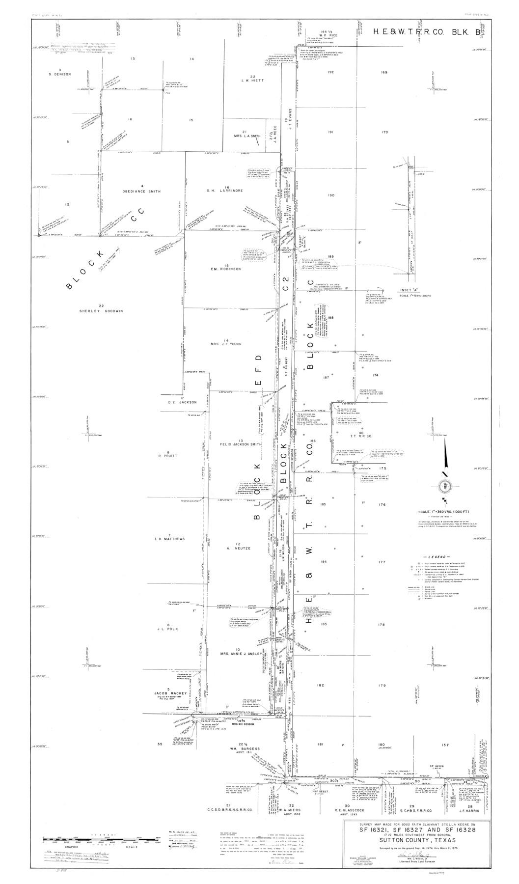
Sutton County Rolled Sketch 63
Survey map made for Good Faith Claimant Stella Keene on SF-16321, SF-16327, and SF-16328
-
Map/Doc
9979
-
Collection
General Map Collection
-
Object Dates
1975/3/21 (Survey Date)
1975/5/13 (File Date)
-
People and Organizations
Wm. C. Wilson, Jr. (Surveyor/Engineer)
-
Counties
Sutton
-
Subjects
Surveying Rolled Sketch
-
Height x Width
77.0 x 45.2 inches
195.6 x 114.8 cm
-
Scale
1" = 360 varas
Part of: General Map Collection
[Surveys along the San Marcos River]
![152, [Surveys along the San Marcos River], General Map Collection](https://historictexasmaps.com/wmedia_w700/maps/152.tif.jpg)
Print $2.00
- Digital $50.00
[Surveys along the San Marcos River]
Size 9.6 x 8.0 inches
Map/Doc 152
Newton County Sketch File O

Print $4.00
- Digital $50.00
Newton County Sketch File O
Size 6.8 x 8.3 inches
Map/Doc 32413
Concho County Rolled Sketch 3

Print $40.00
- Digital $50.00
Concho County Rolled Sketch 3
1949
Size 67.0 x 46.0 inches
Map/Doc 8648
Glasscock County Rolled Sketch 15

Print $20.00
- Digital $50.00
Glasscock County Rolled Sketch 15
1964
Size 36.5 x 35.8 inches
Map/Doc 9059
Wilbarger County Working Sketch 5

Print $20.00
- Digital $50.00
Wilbarger County Working Sketch 5
1940
Size 21.3 x 25.6 inches
Map/Doc 72543
Irion County Rolled Sketch 18C

Print $40.00
- Digital $50.00
Irion County Rolled Sketch 18C
Size 84.7 x 45.5 inches
Map/Doc 9254
Leon County Sketch File 2

Print $4.00
- Digital $50.00
Leon County Sketch File 2
1852
Size 8.1 x 5.1 inches
Map/Doc 29711
Leon County Working Sketch 24

Print $20.00
- Digital $50.00
Leon County Working Sketch 24
1967
Size 23.3 x 29.0 inches
Map/Doc 70423
Duval County Working Sketch 34

Print $20.00
- Digital $50.00
Duval County Working Sketch 34
1953
Size 35.8 x 25.5 inches
Map/Doc 68758
Amistad International Reservoir on Rio Grande 104

Print $20.00
- Digital $50.00
Amistad International Reservoir on Rio Grande 104
1950
Size 28.5 x 40.9 inches
Map/Doc 75535
Smith County Sketch File 16

Print $116.00
- Digital $50.00
Smith County Sketch File 16
1966
Size 10.8 x 7.3 inches
Map/Doc 36781
El Paso County Boundary File 12

Print $16.00
- Digital $50.00
El Paso County Boundary File 12
Size 13.9 x 8.5 inches
Map/Doc 53153
You may also like
Erath County Working Sketch 1

Print $20.00
- Digital $50.00
Erath County Working Sketch 1
Size 16.7 x 20.7 inches
Map/Doc 69082
City of Lamesa, Texas

Print $40.00
- Digital $50.00
City of Lamesa, Texas
Size 52.2 x 43.2 inches
Map/Doc 89855
General Highway Map, Marion County, Texas

Print $20.00
General Highway Map, Marion County, Texas
1940
Size 18.3 x 24.7 inches
Map/Doc 79184
Caldwell County Working Sketch 8

Print $20.00
- Digital $50.00
Caldwell County Working Sketch 8
1964
Size 29.1 x 22.8 inches
Map/Doc 67838
Pecos County Boundary File 69

Print $22.00
- Digital $50.00
Pecos County Boundary File 69
Size 7.8 x 3.4 inches
Map/Doc 57890
Pecos County Working Sketch 95

Print $20.00
- Digital $50.00
Pecos County Working Sketch 95
1970
Size 42.6 x 40.6 inches
Map/Doc 71568
Colorado County Sketch File 16

Print $4.00
- Digital $50.00
Colorado County Sketch File 16
Size 8.2 x 10.3 inches
Map/Doc 18945
Fannin County Sketch File 13

Print $4.00
- Digital $50.00
Fannin County Sketch File 13
Size 8.1 x 7.9 inches
Map/Doc 22462
Brewster County Working Sketch 100

Print $40.00
- Digital $50.00
Brewster County Working Sketch 100
1979
Size 41.0 x 55.2 inches
Map/Doc 67700
Chart of the Harbour of San [Luis]
![72763, Chart of the Harbour of San [Luis], General Map Collection](https://historictexasmaps.com/wmedia_w700/maps/72763.tif.jpg)
Print $20.00
- Digital $50.00
Chart of the Harbour of San [Luis]
1846
Size 27.7 x 18.3 inches
Map/Doc 72763
Tyler County Sketch File 3a

Print $4.00
- Digital $50.00
Tyler County Sketch File 3a
1857
Size 6.2 x 8.2 inches
Map/Doc 38626
Jackson County Working Sketch 5

Print $20.00
- Digital $50.00
Jackson County Working Sketch 5
1953
Size 26.2 x 26.0 inches
Map/Doc 66453