Irion County Rolled Sketch 18C
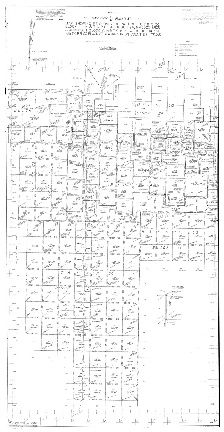
Rocker B Ranch - Map showing re-survey of part of T. & P. R.R. Co. Block 1, H. & T. C. R.R. Co. Block 24, Maddox Bros. & Anderson Block A, H. & T. C. R.R. Co. Block 14, and H. & T. C. R.R. Co. Block 27, Reagan & Irion Counties, Texas
-
Map/Doc
9254
-
Collection
General Map Collection
-
Object Dates
1977 (Survey Date)
1978/3/3 (File Date)
-
People and Organizations
Wm. C. Wilson, Jr. (Surveyor/Engineer)
-
Counties
Irion Reagan
-
Subjects
Surveying Rolled Sketch
-
Height x Width
84.7 x 45.5 inches
215.1 x 115.6 cm
-
Scale
1" = 600 varas
-
Comments
See Irion County Rolled Sketch 18A (6327) and Irion County Rolled Sketch 18B (46087).
Related maps
Irion County Rolled Sketch 18B

Print $152.00
- Digital $50.00
Irion County Rolled Sketch 18B
1978
Size 10.6 x 15.2 inches
Map/Doc 46087
Irion County Rolled Sketch 18A

Print $20.00
- Digital $50.00
Irion County Rolled Sketch 18A
Size 45.5 x 29.8 inches
Map/Doc 6327
Reagan County Rolled Sketch 40

Print $40.00
- Digital $50.00
Reagan County Rolled Sketch 40
Size 90.0 x 39.3 inches
Map/Doc 9831
Part of: General Map Collection
Bastrop County Sketch File 13

Print $6.00
- Digital $50.00
Bastrop County Sketch File 13
1845
Size 10.1 x 15.8 inches
Map/Doc 14070
Red River, Kelsey Sheet, Upshur County

Print $4.00
- Digital $50.00
Red River, Kelsey Sheet, Upshur County
1933
Size 21.1 x 24.2 inches
Map/Doc 65056
Tyler County Working Sketch 8

Print $20.00
- Digital $50.00
Tyler County Working Sketch 8
1937
Size 31.0 x 34.9 inches
Map/Doc 69478
San Patricio County Working Sketch 12

Print $40.00
- Digital $50.00
San Patricio County Working Sketch 12
Size 51.4 x 40.7 inches
Map/Doc 63774
Mexico y sus Cercanias

Print $20.00
- Digital $50.00
Mexico y sus Cercanias
Size 26.1 x 34.2 inches
Map/Doc 96809
Lampasas County Working Sketch 17

Print $20.00
- Digital $50.00
Lampasas County Working Sketch 17
1977
Size 24.0 x 13.2 inches
Map/Doc 70294
Flight Mission No. DQN-2K, Frame 10, Calhoun County

Print $20.00
- Digital $50.00
Flight Mission No. DQN-2K, Frame 10, Calhoun County
1953
Size 18.5 x 22.0 inches
Map/Doc 84227
Terrell County Sketch File 24a

Print $20.00
- Digital $50.00
Terrell County Sketch File 24a
1932
Size 30.4 x 42.2 inches
Map/Doc 10388
Matagorda County Sketch File 37

Print $4.00
- Digital $50.00
Matagorda County Sketch File 37
Size 11.3 x 8.8 inches
Map/Doc 30830
Proceedings of The International (Water) Boundary Commission United States and Mexico Treaties of 1884 and 1889, Volume 1

Proceedings of The International (Water) Boundary Commission United States and Mexico Treaties of 1884 and 1889, Volume 1
Map/Doc 83146
Upshur County Working Sketch 4

Print $20.00
- Digital $50.00
Upshur County Working Sketch 4
1939
Size 21.6 x 15.3 inches
Map/Doc 69560
Montgomery County Rolled Sketch 26A

Print $20.00
- Digital $50.00
Montgomery County Rolled Sketch 26A
1941
Size 26.9 x 36.8 inches
Map/Doc 6808
You may also like
The Republic County of Gonzales. May 24, 1838

Print $20.00
The Republic County of Gonzales. May 24, 1838
2020
Size 14.7 x 21.7 inches
Map/Doc 96156
Post Route Map of the State of Texas with Adjacent Parts of Louisiana, Arkansas, Indian Territory and the Republic of Mexico Showing Post Offices with the Intermediate Distances and Mail Routes in Operation on the 1st of April 1891

Print $40.00
Post Route Map of the State of Texas with Adjacent Parts of Louisiana, Arkansas, Indian Territory and the Republic of Mexico Showing Post Offices with the Intermediate Distances and Mail Routes in Operation on the 1st of April 1891
1891
Size 44.5 x 58.2 inches
Map/Doc 89061
Marion County Working Sketch 2

Print $20.00
- Digital $50.00
Marion County Working Sketch 2
Size 37.5 x 28.2 inches
Map/Doc 70777
Freestone County Working Sketch 18

Print $20.00
- Digital $50.00
Freestone County Working Sketch 18
1980
Size 43.3 x 46.9 inches
Map/Doc 69260
Calhoun County Sketch File 8

Print $12.00
- Digital $50.00
Calhoun County Sketch File 8
1948
Size 14.2 x 9.0 inches
Map/Doc 35930
Dallas County Rolled Sketch 2

Print $40.00
- Digital $50.00
Dallas County Rolled Sketch 2
1950
Size 36.9 x 51.0 inches
Map/Doc 8766
Crane County Working Sketch 9

Print $20.00
- Digital $50.00
Crane County Working Sketch 9
1937
Size 47.6 x 42.8 inches
Map/Doc 68286
Bowie County Working Sketch 12

Print $20.00
- Digital $50.00
Bowie County Working Sketch 12
1959
Size 31.3 x 23.3 inches
Map/Doc 67416
Mason County Working Sketch 19

Print $20.00
- Digital $50.00
Mason County Working Sketch 19
1981
Size 27.0 x 37.1 inches
Map/Doc 70855
Presidio County Working Sketch 25

Print $20.00
- Digital $50.00
Presidio County Working Sketch 25
1945
Size 22.8 x 18.9 inches
Map/Doc 71701
Brewster County Rolled Sketch 114

Print $20.00
- Digital $50.00
Brewster County Rolled Sketch 114
1964
Size 11.5 x 18.5 inches
Map/Doc 5271
Maverick County Working Sketch 15

Print $20.00
- Digital $50.00
Maverick County Working Sketch 15
1970
Size 34.6 x 24.7 inches
Map/Doc 70907