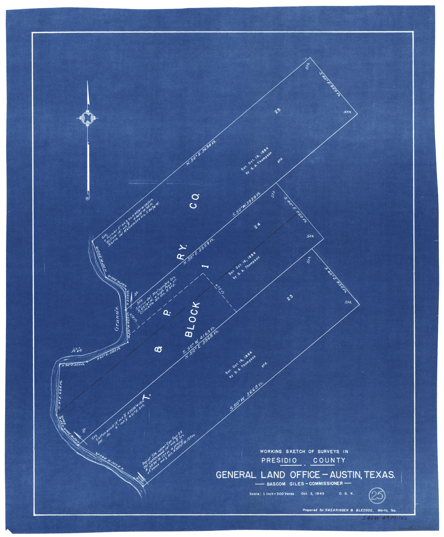
Presidio County Working Sketch 25
-
Map/Doc
71701
-
Collection
General Map Collection
-
Object Dates
10/3/1945 (Creation Date)
-
People and Organizations
Otto G. Kurio (Draftsman)
-
Counties
Presidio
-
Subjects
Surveying Working Sketch
-
Height x Width
22.8 x 18.9 inches
57.9 x 48.0 cm
-
Scale
1" = 300 varas
Part of: General Map Collection
Reeves County Sketch File 20

Print $8.00
- Digital $50.00
Reeves County Sketch File 20
1943
Size 9.9 x 8.5 inches
Map/Doc 35216
Morris County Rolled Sketch 2A

Print $20.00
- Digital $50.00
Morris County Rolled Sketch 2A
Size 24.3 x 19.1 inches
Map/Doc 10250
Goliad County Working Sketch 12

Print $20.00
- Digital $50.00
Goliad County Working Sketch 12
1942
Size 42.5 x 44.6 inches
Map/Doc 63202
[Rio Grande & Eagle Pass - Stockdale to Cuero]
![64048, [Rio Grande & Eagle Pass - Stockdale to Cuero], General Map Collection](https://historictexasmaps.com/wmedia_w700/maps/64048.tif.jpg)
Print $40.00
- Digital $50.00
[Rio Grande & Eagle Pass - Stockdale to Cuero]
Size 19.9 x 122.5 inches
Map/Doc 64048
Flight Mission No. DAG-21K, Frame 97, Matagorda County

Print $20.00
- Digital $50.00
Flight Mission No. DAG-21K, Frame 97, Matagorda County
1952
Size 18.4 x 22.2 inches
Map/Doc 86426
Pecos County Rolled Sketch 133

Print $40.00
- Digital $50.00
Pecos County Rolled Sketch 133
1952
Size 50.8 x 12.1 inches
Map/Doc 9729
San Jacinto County Working Sketch 7

Print $20.00
- Digital $50.00
San Jacinto County Working Sketch 7
1935
Size 32.0 x 41.4 inches
Map/Doc 63720
Hardeman County Sketch File 13

Print $20.00
- Digital $50.00
Hardeman County Sketch File 13
Size 26.3 x 23.7 inches
Map/Doc 11625
Dawson County Sketch File 10

Print $4.00
- Digital $50.00
Dawson County Sketch File 10
1927
Size 11.4 x 8.8 inches
Map/Doc 20544
Zapata County Sketch File 6

Print $22.00
- Digital $50.00
Zapata County Sketch File 6
1913
Size 22.1 x 32.7 inches
Map/Doc 12720
Terrell County Sketch File 24a

Print $20.00
- Digital $50.00
Terrell County Sketch File 24a
1932
Size 30.4 x 42.2 inches
Map/Doc 10388
Refugio County Working Sketch 12

Print $40.00
- Digital $50.00
Refugio County Working Sketch 12
1949
Size 42.6 x 48.2 inches
Map/Doc 63521
You may also like
Township 1 South Range 11 West, South Western District, Louisiana

Print $20.00
- Digital $50.00
Township 1 South Range 11 West, South Western District, Louisiana
1881
Size 19.7 x 24.8 inches
Map/Doc 65879
Map of section no. 7 of a survey of Padre Island made for the Office of the Attorney General of the State of Texas

Print $40.00
- Digital $50.00
Map of section no. 7 of a survey of Padre Island made for the Office of the Attorney General of the State of Texas
1941
Size 56.3 x 41.2 inches
Map/Doc 2263
Trinity River, Crandell Sheet/East Fork of Trinity River

Print $20.00
- Digital $50.00
Trinity River, Crandell Sheet/East Fork of Trinity River
1921
Size 42.0 x 35.5 inches
Map/Doc 65188
General Highway Map, Travis County, Texas

Print $20.00
General Highway Map, Travis County, Texas
1961
Size 18.2 x 24.7 inches
Map/Doc 79680
Brazos Santiago & Boca Chica entrances, Texas

Print $20.00
- Digital $50.00
Brazos Santiago & Boca Chica entrances, Texas
1867
Size 18.1 x 25.6 inches
Map/Doc 72927
Jack County Sketch File 11

Print $4.00
- Digital $50.00
Jack County Sketch File 11
1858
Size 10.2 x 8.1 inches
Map/Doc 27531
The Coast of Texas

Print $20.00
- Digital $50.00
The Coast of Texas
1844
Size 18.3 x 26.9 inches
Map/Doc 72697
Chambers County Rolled Sketch 28

Print $91.00
- Digital $50.00
Chambers County Rolled Sketch 28
1949
Size 9.9 x 15.2 inches
Map/Doc 44097
[Surveys near Brushy Creek]
![360, [Surveys near Brushy Creek], General Map Collection](https://historictexasmaps.com/wmedia_w700/maps/360.tif.jpg)
Print $2.00
- Digital $50.00
[Surveys near Brushy Creek]
1845
Size 10.0 x 7.9 inches
Map/Doc 360
Flight Mission No. DCL-6C, Frame 134, Kenedy County

Print $20.00
- Digital $50.00
Flight Mission No. DCL-6C, Frame 134, Kenedy County
1943
Size 18.5 x 22.2 inches
Map/Doc 85964
United States - Gulf Coast - Galveston to Rio Grande

Print $20.00
- Digital $50.00
United States - Gulf Coast - Galveston to Rio Grande
1940
Size 27.0 x 18.2 inches
Map/Doc 72755
Collin County Sketch File 9

Print $4.00
- Digital $50.00
Collin County Sketch File 9
1878
Size 8.3 x 10.1 inches
Map/Doc 18870