Terrell County Sketch File 24a
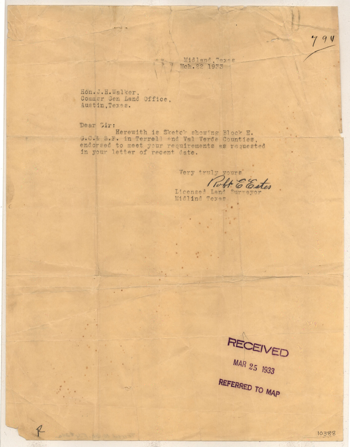
[Sketch of G. C. & S. F. R.R. Co. Block H in Terrell and Val Verde Counties and accompanying letter]
-
Map/Doc
10388
-
Collection
General Map Collection
-
Object Dates
6/6/1932 (Creation Date)
4/5/1933 (File Date)
3/22/1933 (Correspondence Date)
-
People and Organizations
Robert E. Estes (Surveyor/Engineer)
-
Counties
Terrell Val Verde
-
Subjects
Surveying Sketch File
-
Height x Width
30.4 x 42.2 inches
77.2 x 107.2 cm
-
Medium
multi-page, multi-format
-
Scale
1" = 1000 varas
-
Comments
See Terrell County Sketch File 23 (37954) for report and Terrell County Sketch File 24 (10387) for another copy of this sketch.
-
Features
Lemmon's Place
Meyer's Spring
Painted Spring
Rocky Canyon
Related maps
Terrell County Sketch File 24

Print $20.00
- Digital $50.00
Terrell County Sketch File 24
1932
Size 22.0 x 41.8 inches
Map/Doc 10387
Terrell County Sketch File 23

Print $10.00
- Digital $50.00
Terrell County Sketch File 23
1932
Size 14.3 x 8.9 inches
Map/Doc 37954
Part of: General Map Collection
Oldham County Rolled Sketch 2A

Print $40.00
- Digital $50.00
Oldham County Rolled Sketch 2A
1886
Size 35.9 x 55.6 inches
Map/Doc 9640
Flight Mission No. BRA-3M, Frame 194, Jefferson County

Print $20.00
- Digital $50.00
Flight Mission No. BRA-3M, Frame 194, Jefferson County
1953
Size 18.8 x 22.4 inches
Map/Doc 85409
Wichita County Working Sketch 23

Print $20.00
- Digital $50.00
Wichita County Working Sketch 23
1963
Size 28.4 x 30.8 inches
Map/Doc 72533
Crockett County Working Sketch 43

Print $20.00
- Digital $50.00
Crockett County Working Sketch 43
1931
Size 26.1 x 21.7 inches
Map/Doc 68376
Potter County Sketch File 3

Print $20.00
- Digital $50.00
Potter County Sketch File 3
1883
Size 37.5 x 47.6 inches
Map/Doc 10574
Carson County Working Sketch 3

Print $20.00
- Digital $50.00
Carson County Working Sketch 3
1922
Size 18.3 x 26.3 inches
Map/Doc 67874
Flight Mission No. CGI-3N, Frame 162, Cameron County

Print $20.00
- Digital $50.00
Flight Mission No. CGI-3N, Frame 162, Cameron County
1954
Size 18.6 x 22.3 inches
Map/Doc 84626
Map of the Reconnaissance in Texas by Lieuts Blake & Meade of the Corps of Topl. Engrs.

Print $20.00
- Digital $50.00
Map of the Reconnaissance in Texas by Lieuts Blake & Meade of the Corps of Topl. Engrs.
1845
Size 27.7 x 18.2 inches
Map/Doc 72893
Chambers County Sketch File 16

Print $4.00
- Digital $50.00
Chambers County Sketch File 16
Size 7.9 x 12.7 inches
Map/Doc 17566

Hays County Working Sketch 4

Print $20.00
- Digital $50.00
Hays County Working Sketch 4
1928
Size 25.4 x 21.7 inches
Map/Doc 66078
Fisher County Rolled Sketch Y

Print $20.00
- Digital $50.00
Fisher County Rolled Sketch Y
Size 42.1 x 25.4 inches
Map/Doc 5878
You may also like
Nueces County Rolled Sketch 100

Print $20.00
- Digital $50.00
Nueces County Rolled Sketch 100
Size 30.6 x 40.7 inches
Map/Doc 10209
Hardin County Rolled Sketch 6

Print $20.00
- Digital $50.00
Hardin County Rolled Sketch 6
1938
Size 29.7 x 22.7 inches
Map/Doc 6079
University of Texas System University Lands

Print $20.00
- Digital $50.00
University of Texas System University Lands
1931
Size 23.2 x 17.5 inches
Map/Doc 93241
[Sketch showing B. S. & F. Blks B1 and B2 and surrounding Blocks]
![90137, [Sketch showing B. S. & F. Blks B1 and B2 and surrounding Blocks], Twichell Survey Records](https://historictexasmaps.com/wmedia_w700/maps/90137-1.tif.jpg)
Print $20.00
- Digital $50.00
[Sketch showing B. S. & F. Blks B1 and B2 and surrounding Blocks]
Size 23.3 x 18.3 inches
Map/Doc 90137
Dawson County Sketch File 31

Print $4.00
- Digital $50.00
Dawson County Sketch File 31
1989
Size 11.4 x 9.0 inches
Map/Doc 20614
Nolan County Working Sketch 9

Print $20.00
- Digital $50.00
Nolan County Working Sketch 9
1964
Size 25.0 x 36.8 inches
Map/Doc 71300
Williamson County

Print $40.00
- Digital $50.00
Williamson County
1946
Size 37.3 x 54.8 inches
Map/Doc 77460
Palo Pinto County Rolled Sketch 9

Print $40.00
- Digital $50.00
Palo Pinto County Rolled Sketch 9
Size 78.0 x 30.9 inches
Map/Doc 9675
Flight Mission No. DAG-23K, Frame 17, Matagorda County

Print $20.00
- Digital $50.00
Flight Mission No. DAG-23K, Frame 17, Matagorda County
1953
Size 18.5 x 22.2 inches
Map/Doc 86479
Frio County Rolled Sketch 27

Print $20.00
- Digital $50.00
Frio County Rolled Sketch 27
2013
Size 36.0 x 24.6 inches
Map/Doc 93417
Jefferson County NRC Article 33.136 Sketch 14

Print $164.00
- Digital $50.00
Jefferson County NRC Article 33.136 Sketch 14
2021
Map/Doc 96645
Map of France, Spain, Portugal and Italy engraved to illustrate Mitchell's school and family geography (Inset: Greece and the Ionian Islands)

Print $20.00
- Digital $50.00
Map of France, Spain, Portugal and Italy engraved to illustrate Mitchell's school and family geography (Inset: Greece and the Ionian Islands)
1846
Size 9.5 x 11.8 inches
Map/Doc 93505