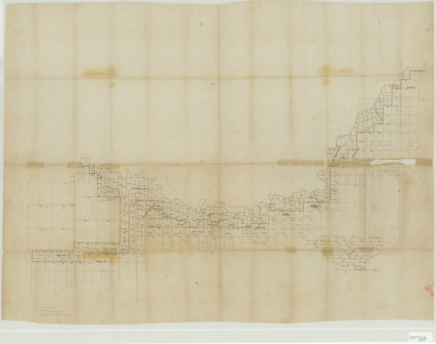
Potter County Sketch File 3
W.S. Mabry's sk. of large part of Potter Co.
- 
                          Map/Doc10574
- 
                            CollectionGeneral Map Collection
- 
                            Object Dates1/18/1883 (Creation Date)
- 
                            People and OrganizationsW.S. Mabry (Surveyor/Engineer)
- 
                            CountiesPotter Oldham Moore Carson Hutchinson
- 
                            SubjectsSurveying Sketch File
- 
                            Height x Width37.5 x 47.6 inches95.3 x 120.9 cm
- 
                            Mediumpaper, manuscript
- 
                            FeaturesParker CreekBucket CreekCottonwood ArroyoSanta La Cruz CreekTecovas CreekWild Horse CreekAmorilla CreekEast Amorilla CreekPedrosa CreekBonita CreekChicken CreekCanadian River
Part of: General Map Collection
            Smith County Working Sketch Graphic Index


                                            Print $20.00                    
                                             -                         Digital $50.00                                    
                Smith County Working Sketch Graphic Index
1948
Size 44.7 x 41.1 inches
                                Map/Doc 76699
            
            Bosque County Sketch File 22


                                            Print $4.00                    
                                             -                         Digital $50.00                                    
                Bosque County Sketch File 22
1863
Size 13.8 x 8.5 inches
                                Map/Doc 14804
            
            Rusk County Sketch File 20


                                            Print $4.00                    
                                    
                Rusk County Sketch File 20
1859
Size 10.2 x 8.1 inches
                                Map/Doc 35530
            
            Edwards County


                                            Print $20.00                    
                                             -                         Digital $50.00                                    
                Edwards County
1893
Size 30.8 x 33.1 inches
                                Map/Doc 3507
            
            Jefferson County Sketch File 39


                                            Print $20.00                    
                                             -                         Digital $50.00                                    
                Jefferson County Sketch File 39
Size 14.3 x 8.7 inches
                                Map/Doc 28218
            
            Map of Fort Bend Co.


                                            Print $20.00                    
                                             -                         Digital $50.00                                    
                Map of Fort Bend Co.
1898
Size 45.3 x 41.6 inches
                                Map/Doc 4949
            
            Flight Mission No. CRC-5R, Frame 35, Chambers County


                                            Print $20.00                    
                                             -                         Digital $50.00                                    
                Flight Mission No. CRC-5R, Frame 35, Chambers County
1956
Size 18.5 x 22.3 inches
                                Map/Doc 84954
            
            State Highway System of Texas Showing Condition of Improvement


                                            Print $20.00                    
                                             -                         Digital $50.00                                    
                State Highway System of Texas Showing Condition of Improvement
1928
Size 24.3 x 36.4 inches
                                Map/Doc 93719
            
            Flight Mission No. DAH-17M, Frame 67, Orange County


                                            Print $20.00                    
                                             -                         Digital $50.00                                    
                Flight Mission No. DAH-17M, Frame 67, Orange County
1953
Size 18.5 x 22.3 inches
                                Map/Doc 86901
            
            Chambers County Rolled Sketch 14


                                            Print $20.00                    
                                             -                         Digital $50.00                                    
                Chambers County Rolled Sketch 14
1935
Size 33.3 x 41.7 inches
                                Map/Doc 8616
            
            Andrews County Sketch File 7


                                            Print $6.00                    
                                             -                         Digital $50.00                                    
                Andrews County Sketch File 7
1942
Size 11.2 x 8.8 inches
                                Map/Doc 12828
            You may also like
            Haskell County Rolled Sketch 15A


                                            Print $3.00                    
                                             -                         Digital $50.00                                    
                Haskell County Rolled Sketch 15A
1991
Size 11.3 x 17.1 inches
                                Map/Doc 6174
            
            Schleicher County Sketch File 11


                                            Print $20.00                    
                                             -                         Digital $50.00                                    
                Schleicher County Sketch File 11
1912
Size 21.5 x 30.5 inches
                                Map/Doc 12298
            
            Hansford County, Texas


                                            Print $20.00                    
                                             -                         Digital $50.00                                    
                Hansford County, Texas
1888
Size 22.6 x 18.6 inches
                                Map/Doc 5033
            
            The Cotton Kingdom: a Traveller's Observations on Cotton and Slavery in the American Slave States


            The Cotton Kingdom: a Traveller's Observations on Cotton and Slavery in the American Slave States
Map/Doc 96571
            
            Flight Mission No. BRA-7M, Frame 74, Jefferson County


                                            Print $20.00                    
                                             -                         Digital $50.00                                    
                Flight Mission No. BRA-7M, Frame 74, Jefferson County
1953
Size 18.6 x 22.4 inches
                                Map/Doc 85496
            
            Fayette County Working Sketch Graphic Index


                                            Print $40.00                    
                                             -                         Digital $50.00                                    
                Fayette County Working Sketch Graphic Index
1978
Size 42.9 x 54.7 inches
                                Map/Doc 76541
            
            Flight Mission No. CGI-4N, Frame 174, Cameron County


                                            Print $20.00                    
                                             -                         Digital $50.00                                    
                Flight Mission No. CGI-4N, Frame 174, Cameron County
1955
Size 18.7 x 22.3 inches
                                Map/Doc 84677
            
            Cooke County Sketch File 44


                                            Print $20.00                    
                                             -                         Digital $50.00                                    
                Cooke County Sketch File 44
1928
Size 20.4 x 20.6 inches
                                Map/Doc 11178
            
            Coast Chart No. 210 Aransas Pass and Corpus Christi Bay with the coast to latitude 27° 12' Texas


                                            Print $20.00                    
                                             -                         Digital $50.00                                    
                Coast Chart No. 210 Aransas Pass and Corpus Christi Bay with the coast to latitude 27° 12' Texas
1913
Size 27.0 x 18.2 inches
                                Map/Doc 72800
            
            El Paso County Rolled Sketch 10


                                            Print $93.00                    
                                             -                         Digital $50.00                                    
                El Paso County Rolled Sketch 10
1883
Size 42.4 x 61.3 inches
                                Map/Doc 8853
            
            Map showing A. & N. W., Raymond Word #3, S.S. Hervey #496, and M. Farley #495 corrected to conform to the judgement in Cause #2888, Travis County District Court, State of Texas versus D. Sullivan, et al


                                            Print $20.00                    
                                             -                         Digital $50.00                                    
                Map showing A. & N. W., Raymond Word #3, S.S. Hervey #496, and M. Farley #495 corrected to conform to the judgement in Cause #2888, Travis County District Court, State of Texas versus D. Sullivan, et al
1915
Size 18.5 x 30.0 inches
                                Map/Doc 75812
             
                             
                                ![91965, [PSL Block B19], Twichell Survey Records](https://historictexasmaps.com/wmedia_w700/maps/91965-1.tif.jpg)