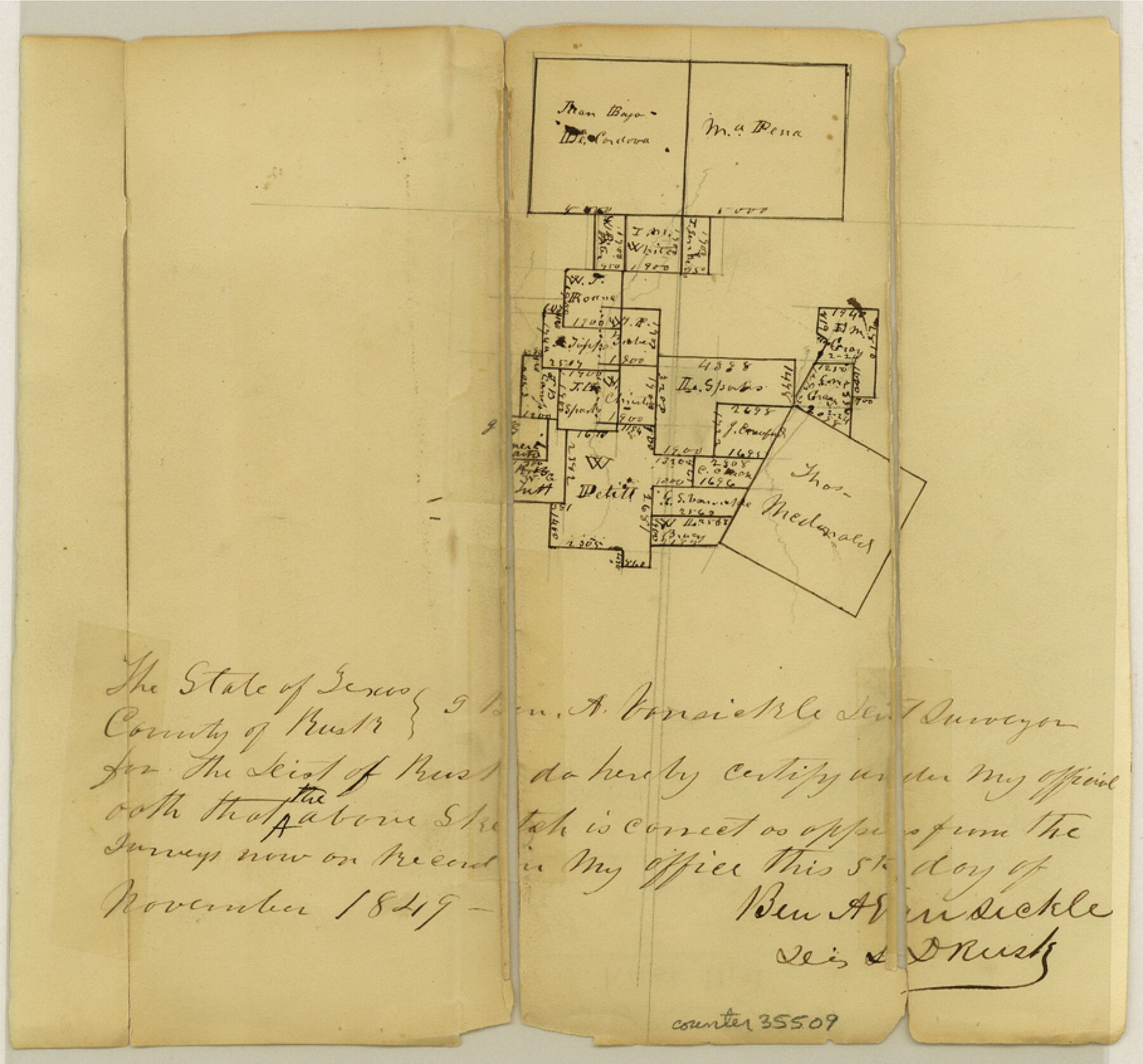
Rusk County Sketch File 11
[Sketch of surveys west from Henderson near the west boundary line of Rusk County]
-
Map/Doc
35509
-
Collection
General Map Collection
-
Object Dates
11/5/1849 (Creation Date)
12/7/1849 (File Date)
-
People and Organizations
Ben A. Vansickle (Surveyor/Engineer)
-
Counties
Rusk
-
Subjects
Surveying Sketch File
-
Height x Width
8.5 x 9.1 inches
21.6 x 23.1 cm
-
Medium
paper, manuscript
Part of: General Map Collection
Floyd County Sketch File 10

Print $12.00
- Digital $50.00
Floyd County Sketch File 10
1912
Size 11.6 x 8.9 inches
Map/Doc 22701
Hemphill County Working Sketch 26

Print $40.00
- Digital $50.00
Hemphill County Working Sketch 26
1974
Size 57.2 x 48.3 inches
Map/Doc 66121
Coke County Working Sketch 3

Print $20.00
- Digital $50.00
Coke County Working Sketch 3
1890
Size 22.3 x 29.2 inches
Map/Doc 68040
Brewster County Working Sketch 21

Print $20.00
- Digital $50.00
Brewster County Working Sketch 21
1937
Size 28.9 x 32.7 inches
Map/Doc 67555
Maps of Gulf Intracoastal Waterway, Texas - Sabine River to the Rio Grande and connecting waterways including ship channels

Print $20.00
- Digital $50.00
Maps of Gulf Intracoastal Waterway, Texas - Sabine River to the Rio Grande and connecting waterways including ship channels
1966
Size 14.5 x 22.3 inches
Map/Doc 61949
Midland County

Print $20.00
- Digital $50.00
Midland County
1930
Size 45.7 x 39.6 inches
Map/Doc 66930
Clay County Boundary File 5

Print $6.00
- Digital $50.00
Clay County Boundary File 5
Size 11.1 x 8.5 inches
Map/Doc 51373
Zavala County Working Sketch 28

Print $20.00
- Digital $50.00
Zavala County Working Sketch 28
1994
Size 34.0 x 43.5 inches
Map/Doc 62103
Zavala County Sketch File 34

Print $4.00
- Digital $50.00
Zavala County Sketch File 34
1887
Size 13.0 x 8.5 inches
Map/Doc 41395
Haskell County Working Sketch 11

Print $20.00
- Digital $50.00
Haskell County Working Sketch 11
1976
Size 38.0 x 33.4 inches
Map/Doc 66069


You may also like
Flight Mission No. CRC-5R, Frame 37, Chambers County

Print $20.00
- Digital $50.00
Flight Mission No. CRC-5R, Frame 37, Chambers County
1956
Size 18.6 x 22.4 inches
Map/Doc 84956
Angelina County Rolled Sketch 3

Print $20.00
- Digital $50.00
Angelina County Rolled Sketch 3
Size 25.9 x 42.5 inches
Map/Doc 77186
Mitchell County Sketch File 14

Print $20.00
- Digital $50.00
Mitchell County Sketch File 14
1930
Size 17.5 x 20.5 inches
Map/Doc 12101
Dawson County Sketch File 13

Print $2.00
- Digital $50.00
Dawson County Sketch File 13
Size 11.2 x 8.6 inches
Map/Doc 20546
Childress County

Print $20.00
- Digital $50.00
Childress County
1921
Size 43.4 x 32.3 inches
Map/Doc 1800
Flight Mission No. DCL-6C, Frame 29, Kenedy County

Print $20.00
- Digital $50.00
Flight Mission No. DCL-6C, Frame 29, Kenedy County
1943
Size 18.6 x 22.4 inches
Map/Doc 85886
Foard County Sketch File 13

Print $6.00
- Digital $50.00
Foard County Sketch File 13
1885
Size 13.0 x 8.5 inches
Map/Doc 22816
Map of the United States constructed from the latest authorities

Print $20.00
- Digital $50.00
Map of the United States constructed from the latest authorities
1825
Size 19.4 x 24.5 inches
Map/Doc 93924
Culberson County Rolled Sketch 68

Print $20.00
- Digital $50.00
Culberson County Rolled Sketch 68
1997
Size 32.0 x 32.9 inches
Map/Doc 76402
Houston Ship Channel, Atkinson Island to Alexander Island

Print $40.00
- Digital $50.00
Houston Ship Channel, Atkinson Island to Alexander Island
1972
Size 36.9 x 50.0 inches
Map/Doc 69901

Webb County Rolled Sketch 28

Print $20.00
- Digital $50.00
Webb County Rolled Sketch 28
1932
Size 27.5 x 20.6 inches
Map/Doc 8186