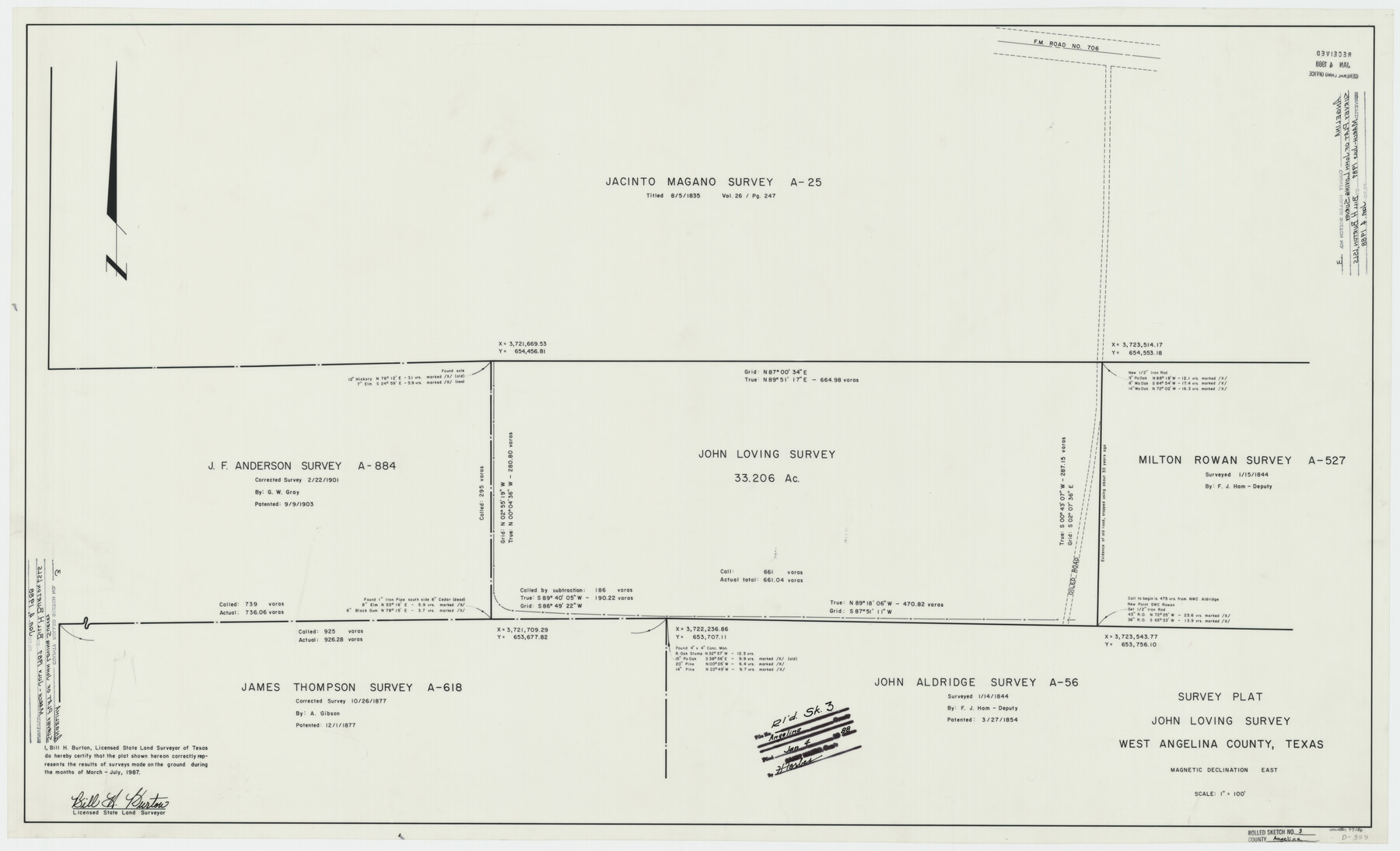
Angelina County Rolled Sketch 3
Survey plat John Loving survey, west Angelina County, Texas
-
Map/Doc
77186
-
Collection
General Map Collection
-
Object Dates
1987 (Survey Date)
1988/1/4 (File Date)
-
People and Organizations
Bill H. Burton (Surveyor/Engineer)
-
Counties
Angelina
-
Subjects
Surveying Rolled Sketch
-
Height x Width
25.9 x 42.5 inches
65.8 x 108.0 cm
-
Medium
mylar, print
-
Scale
1" = 100 feet
Part of: General Map Collection
Castro County Rolled Sketch 13A

Print $20.00
- Digital $50.00
Castro County Rolled Sketch 13A
1967
Size 20.0 x 18.9 inches
Map/Doc 5423
Val Verde County Sketch File B1

Print $20.00
- Digital $50.00
Val Verde County Sketch File B1
1905
Size 21.3 x 20.7 inches
Map/Doc 12543
Brewster County Working Sketch 53

Print $20.00
- Digital $50.00
Brewster County Working Sketch 53
1951
Size 32.1 x 16.5 inches
Map/Doc 67587
Flight Mission No. DIX-6P, Frame 180, Aransas County

Print $20.00
- Digital $50.00
Flight Mission No. DIX-6P, Frame 180, Aransas County
1956
Size 19.0 x 22.6 inches
Map/Doc 83842
Rio Grande, Santa Rosa Sheet

Print $20.00
- Digital $50.00
Rio Grande, Santa Rosa Sheet
1937
Size 37.3 x 37.3 inches
Map/Doc 65116
Notes for map of Montgomery County

Print $20.00
- Digital $50.00
Notes for map of Montgomery County
1844
Size 17.6 x 21.9 inches
Map/Doc 78370
Garza County Sketch File 4a

Print $4.00
- Digital $50.00
Garza County Sketch File 4a
1883
Size 14.2 x 8.8 inches
Map/Doc 24048
Colorado County Rolled Sketch 4

Print $20.00
- Digital $50.00
Colorado County Rolled Sketch 4
1944
Size 31.9 x 21.9 inches
Map/Doc 8643
Crosby County Working Sketch 13

Print $20.00
- Digital $50.00
Crosby County Working Sketch 13
1963
Size 17.9 x 30.7 inches
Map/Doc 68447
Current Miscellaneous File 21

Print $26.00
- Digital $50.00
Current Miscellaneous File 21
1952
Size 10.8 x 8.2 inches
Map/Doc 73865
Jim Wells County Working Sketch 11

Print $20.00
- Digital $50.00
Jim Wells County Working Sketch 11
1953
Size 20.4 x 22.6 inches
Map/Doc 66609
Calhoun County Sketch File 9

Print $14.00
- Digital $50.00
Calhoun County Sketch File 9
1953
Size 11.5 x 14.0 inches
Map/Doc 35936
You may also like
Zavala County Working Sketch 16

Print $20.00
- Digital $50.00
Zavala County Working Sketch 16
1977
Size 41.3 x 43.1 inches
Map/Doc 62091
Crockett County Sketch File HH

Print $38.00
- Digital $50.00
Crockett County Sketch File HH
Size 13.8 x 8.9 inches
Map/Doc 19641
Jackson County Sketch File 2

Print $6.00
- Digital $50.00
Jackson County Sketch File 2
Size 10.2 x 15.5 inches
Map/Doc 27619
Mills County Working Sketch 17

Print $20.00
- Digital $50.00
Mills County Working Sketch 17
1963
Size 20.4 x 17.9 inches
Map/Doc 71047
Ector County Working Sketch 27

Print $20.00
- Digital $50.00
Ector County Working Sketch 27
Size 28.0 x 32.7 inches
Map/Doc 68870
Best Route for Movements of Troops from Laredo to Ringold [sic] Barracks, Texas
![79299, Best Route for Movements of Troops from Laredo to Ringold [sic] Barracks, Texas, Texas State Library and Archives](https://historictexasmaps.com/wmedia_w700/maps/79299.tif.jpg)
Print $20.00
Best Route for Movements of Troops from Laredo to Ringold [sic] Barracks, Texas
1865
Size 18.9 x 15.3 inches
Map/Doc 79299
Map of Capitol Syndicate Subdivisions of Capitol Land Reservation Leagues

Print $40.00
- Digital $50.00
Map of Capitol Syndicate Subdivisions of Capitol Land Reservation Leagues
1906
Size 44.6 x 72.6 inches
Map/Doc 93131
Loving County Rolled Sketch 8

Print $20.00
- Digital $50.00
Loving County Rolled Sketch 8
1975
Size 30.5 x 17.4 inches
Map/Doc 6639

Schleicher County Working Sketch 12

Print $20.00
- Digital $50.00
Schleicher County Working Sketch 12
1925
Size 23.7 x 22.2 inches
Map/Doc 63814
Newton County Rolled Sketch 25

Print $20.00
- Digital $50.00
Newton County Rolled Sketch 25
1893
Size 22.3 x 18.6 inches
Map/Doc 6852
Smith County Working Sketch 16

Print $20.00
- Digital $50.00
Smith County Working Sketch 16
1988
Size 33.6 x 44.9 inches
Map/Doc 63901