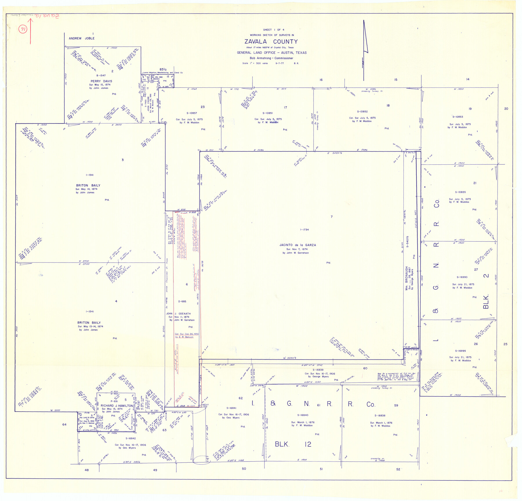
Zavala County Working Sketch 16
-
Map/Doc
62091
-
Collection
General Map Collection
-
Object Dates
9/7/1977 (Creation Date)
-
People and Organizations
Beverly Robison (Draftsman)
-
Counties
Zavala
-
Subjects
Surveying Working Sketch
-
Height x Width
41.3 x 43.1 inches
104.9 x 109.5 cm
-
Scale
1" = 300 varas
Part of: General Map Collection
Map of Eagle Lake

Print $20.00
- Digital $50.00
Map of Eagle Lake
1938
Size 13.0 x 17.0 inches
Map/Doc 2208
Calhoun County Rolled Sketch 6

Print $20.00
- Digital $50.00
Calhoun County Rolled Sketch 6
Size 24.0 x 22.5 inches
Map/Doc 5362
Tyler County Sketch File 7

Print $4.00
- Digital $50.00
Tyler County Sketch File 7
1874
Size 13.4 x 7.7 inches
Map/Doc 38637
Dawson County Working Sketch 10

Print $20.00
- Digital $50.00
Dawson County Working Sketch 10
1944
Size 15.6 x 13.6 inches
Map/Doc 68554
Anderson County Working Sketch 44

Print $20.00
- Digital $50.00
Anderson County Working Sketch 44
1991
Size 27.7 x 32.3 inches
Map/Doc 67044
San Patricio County Working Sketch 21

Print $20.00
- Digital $50.00
San Patricio County Working Sketch 21
1981
Size 19.7 x 14.5 inches
Map/Doc 63783
Right of Way and Track Map, the Missouri, Kansas and Texas Ry. of Texas operated by the Missouri, Kansas and Texas Ry. of Texas, San Antonio Division

Print $40.00
- Digital $50.00
Right of Way and Track Map, the Missouri, Kansas and Texas Ry. of Texas operated by the Missouri, Kansas and Texas Ry. of Texas, San Antonio Division
1918
Size 25.6 x 58.7 inches
Map/Doc 64581
Flight Mission No. DIX-6P, Frame 182, Aransas County

Print $20.00
- Digital $50.00
Flight Mission No. DIX-6P, Frame 182, Aransas County
1956
Size 19.1 x 22.8 inches
Map/Doc 83844
Flight Mission No. DQO-7K, Frame 77, Galveston County

Print $20.00
- Digital $50.00
Flight Mission No. DQO-7K, Frame 77, Galveston County
1952
Size 18.9 x 22.6 inches
Map/Doc 85104
McMullen County Sketch File 39

Print $4.00
- Digital $50.00
McMullen County Sketch File 39
1938
Size 13.3 x 8.7 inches
Map/Doc 31413
Kenedy County Rolled Sketch 10

Print $20.00
- Digital $50.00
Kenedy County Rolled Sketch 10
1915
Size 21.7 x 35.7 inches
Map/Doc 6470
Sabine River, Dixon Sheet/Cowleach Fork of the Sabine River

Print $20.00
- Digital $50.00
Sabine River, Dixon Sheet/Cowleach Fork of the Sabine River
1935
Size 44.0 x 18.5 inches
Map/Doc 65145
You may also like
Comal County Sketch File 10

Print $4.00
- Digital $50.00
Comal County Sketch File 10
1849
Size 12.7 x 7.6 inches
Map/Doc 19020
Map of Clay Co.

Print $40.00
- Digital $50.00
Map of Clay Co.
1896
Size 51.9 x 31.0 inches
Map/Doc 4785
Sketch Showing Land Ties with Houston & Texas Central Railroad Through Harris County, Texas

Print $20.00
- Digital $50.00
Sketch Showing Land Ties with Houston & Texas Central Railroad Through Harris County, Texas
1880
Size 7.3 x 27.0 inches
Map/Doc 66739
Upton County Working Sketch 8

Print $20.00
- Digital $50.00
Upton County Working Sketch 8
1916
Size 21.9 x 16.8 inches
Map/Doc 69504
Limestone County Working Sketch 3

Print $20.00
- Digital $50.00
Limestone County Working Sketch 3
1919
Size 28.9 x 28.5 inches
Map/Doc 70553
Calhoun County Rolled Sketch 14

Print $20.00
- Digital $50.00
Calhoun County Rolled Sketch 14
Size 22.1 x 40.5 inches
Map/Doc 5454
Lipscomb County Working Sketch 6

Print $20.00
- Digital $50.00
Lipscomb County Working Sketch 6
1980
Size 35.7 x 20.8 inches
Map/Doc 70582
Harris County Rolled Sketch 42

Print $20.00
- Digital $50.00
Harris County Rolled Sketch 42
1919
Size 15.7 x 19.5 inches
Map/Doc 6100
The Republic County of Nacogdoches. Proposed, Late Fall 1837-January 1, 1838

Print $20.00
The Republic County of Nacogdoches. Proposed, Late Fall 1837-January 1, 1838
2020
Size 17.8 x 21.7 inches
Map/Doc 96243
Real County Sketch File 10

Print $6.00
- Digital $50.00
Real County Sketch File 10
1932
Size 10.3 x 15.0 inches
Map/Doc 35063
Amistad International Reservoir on Rio Grande 103

Print $20.00
- Digital $50.00
Amistad International Reservoir on Rio Grande 103
1950
Size 28.5 x 41.1 inches
Map/Doc 75534
Flight Mission No. BRA-8M, Frame 128, Jefferson County

Print $20.00
- Digital $50.00
Flight Mission No. BRA-8M, Frame 128, Jefferson County
1953
Size 18.6 x 22.3 inches
Map/Doc 85624