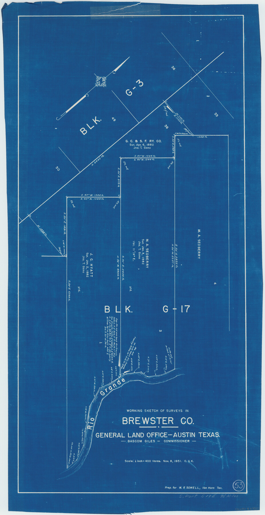
Brewster County Working Sketch 53
-
Map/Doc
67587
-
Collection
General Map Collection
-
Object Dates
11/8/1951 (Creation Date)
-
People and Organizations
Otto G. Kurio (Draftsman)
-
Counties
Brewster
-
Subjects
Surveying Working Sketch
-
Height x Width
32.1 x 16.5 inches
81.5 x 41.9 cm
-
Scale
1" = 400 varas
Part of: General Map Collection

Dimmit County Working Sketch 4

Print $20.00
- Digital $50.00
Dimmit County Working Sketch 4
1911
Size 24.9 x 12.3 inches
Map/Doc 68665
Ward County Working Sketch Graphic Index - sheet A

Print $40.00
- Digital $50.00
Ward County Working Sketch Graphic Index - sheet A
1932
Size 30.8 x 52.8 inches
Map/Doc 76731
Maverick County Rolled Sketch 14A

Print $20.00
- Digital $50.00
Maverick County Rolled Sketch 14A
Size 35.4 x 18.2 inches
Map/Doc 6708
Flight Mission No. DQN-7K, Frame 39, Calhoun County

Print $20.00
- Digital $50.00
Flight Mission No. DQN-7K, Frame 39, Calhoun County
1953
Size 19.0 x 22.5 inches
Map/Doc 84477
Throckmorton County Working Sketch 5

Print $20.00
- Digital $50.00
Throckmorton County Working Sketch 5
1927
Size 31.8 x 24.4 inches
Map/Doc 62114
Current Miscellaneous File 120

Print $14.00
- Digital $50.00
Current Miscellaneous File 120
Size 8.5 x 11.0 inches
Map/Doc 88754
Webb County Working Sketch 4

Print $20.00
- Digital $50.00
Webb County Working Sketch 4
1907
Size 45.6 x 42.5 inches
Map/Doc 72369
Galveston County NRC Article 33.136 Sketch 2

Print $46.00
- Digital $50.00
Galveston County NRC Article 33.136 Sketch 2
2000
Size 23.1 x 34.4 inches
Map/Doc 61565
Kimble County Working Sketch 60

Print $20.00
- Digital $50.00
Kimble County Working Sketch 60
1964
Size 43.8 x 38.2 inches
Map/Doc 70128
A Map of the United States including every county enumerated in the last census & since formed with the population of the several states, railroads, canals, & c.

A Map of the United States including every county enumerated in the last census & since formed with the population of the several states, railroads, canals, & c.
Size 46.0 x 61.0 inches
Map/Doc 95918
Flight Mission No. BRA-16M, Frame 114, Jefferson County

Print $20.00
- Digital $50.00
Flight Mission No. BRA-16M, Frame 114, Jefferson County
1953
Size 18.5 x 22.3 inches
Map/Doc 85724
You may also like
General Highway Map, Brewster County, Texas

Print $20.00
General Highway Map, Brewster County, Texas
1940
Size 18.5 x 25.2 inches
Map/Doc 79027
Winkler County

Print $20.00
- Digital $50.00
Winkler County
1901
Size 44.1 x 37.9 inches
Map/Doc 63131
Reeves County Working Sketch 52

Print $40.00
- Digital $50.00
Reeves County Working Sketch 52
1977
Size 60.3 x 41.9 inches
Map/Doc 63495
Flight Mission No. BQR-9K, Frame 7, Brazoria County

Print $20.00
- Digital $50.00
Flight Mission No. BQR-9K, Frame 7, Brazoria County
1952
Size 18.7 x 22.5 inches
Map/Doc 84036
Galveston to Rio Grande

Print $20.00
- Digital $50.00
Galveston to Rio Grande
1985
Size 45.4 x 37.5 inches
Map/Doc 69958
Carte de la Louisiane et du Cours du Mississipi

Print $20.00
- Digital $50.00
Carte de la Louisiane et du Cours du Mississipi
1718
Size 20.6 x 27.3 inches
Map/Doc 93821
Amistad International Reservoir on Rio Grande Key Sheet

Print $20.00
- Digital $50.00
Amistad International Reservoir on Rio Grande Key Sheet
1960
Size 13.0 x 32.4 inches
Map/Doc 73345
Sketch of a reconnaissance of Aransas and Corpus Christi Bays

Print $20.00
- Digital $50.00
Sketch of a reconnaissance of Aransas and Corpus Christi Bays
1855
Size 25.5 x 18.2 inches
Map/Doc 72968
La Salle County Working Sketch 56

Print $20.00
- Digital $50.00
La Salle County Working Sketch 56
2012
Size 25.5 x 23.0 inches
Map/Doc 93277
Wise County Rolled Sketch 1

Print $40.00
- Digital $50.00
Wise County Rolled Sketch 1
1941
Size 40.6 x 52.8 inches
Map/Doc 10154
[Map showing T&P Lands in El Paso County]
![88934, [Map showing T&P Lands in El Paso County], Library of Congress](https://historictexasmaps.com/wmedia_w700/maps/88934.tif.jpg)
Print $20.00
[Map showing T&P Lands in El Paso County]
Size 17.3 x 22.2 inches
Map/Doc 88934
[G. C. & S. 35, Part of H. & T. C. 49, Capitol Leagues 217, 218, 223, 224, 225]
![90687, [G. C. & S. 35, Part of H. & T. C. 49, Capitol Leagues 217, 218, 223, 224, 225], Twichell Survey Records](https://historictexasmaps.com/wmedia_w700/maps/90687-1.tif.jpg)
Print $3.00
- Digital $50.00
[G. C. & S. 35, Part of H. & T. C. 49, Capitol Leagues 217, 218, 223, 224, 225]
1903
Size 12.4 x 11.0 inches
Map/Doc 90687