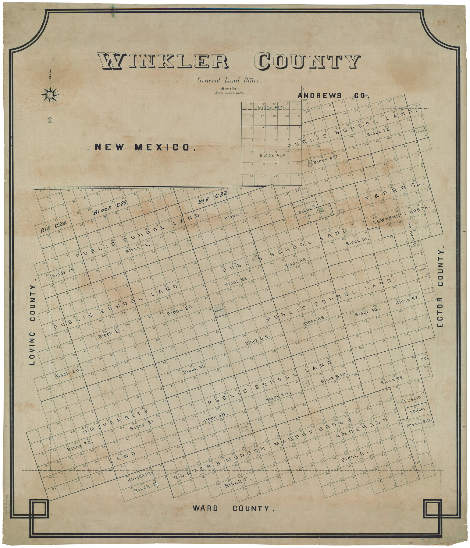
Winkler County
-
Map/Doc
63131
-
Collection
General Map Collection
-
Object Dates
1901 (Creation Date)
-
People and Organizations
Texas General Land Office (Publisher)
-
Counties
Winkler
-
Subjects
County
-
Height x Width
44.1 x 37.9 inches
112.0 x 96.3 cm
Part of: General Map Collection
Galveston - Texas City, Texas

Galveston - Texas City, Texas
2008
Size 26.9 x 39.0 inches
Map/Doc 96858
Tracing "A" [showing Rio Grande and settlements along river]
![72888, Tracing "A" [showing Rio Grande and settlements along river], General Map Collection](https://historictexasmaps.com/wmedia_w700/maps/72888.tif.jpg)
Print $20.00
- Digital $50.00
Tracing "A" [showing Rio Grande and settlements along river]
1881
Size 18.2 x 25.9 inches
Map/Doc 72888
Duval County Sketch File 49

Print $6.00
- Digital $50.00
Duval County Sketch File 49
Size 14.5 x 9.1 inches
Map/Doc 21409
Flight Mission No. CLL-4N, Frame 36, Willacy County

Print $20.00
- Digital $50.00
Flight Mission No. CLL-4N, Frame 36, Willacy County
1954
Size 18.4 x 22.1 inches
Map/Doc 87109
Polk County Working Sketch 6

Print $20.00
- Digital $50.00
Polk County Working Sketch 6
1933
Size 22.8 x 32.7 inches
Map/Doc 71621
Lavaca County Working Sketch 26

Print $20.00
- Digital $50.00
Lavaca County Working Sketch 26
1986
Size 25.0 x 28.1 inches
Map/Doc 70379
Gaines County

Print $40.00
- Digital $50.00
Gaines County
1902
Size 38.9 x 49.7 inches
Map/Doc 66832
Zapata County Sketch File 17

Print $32.00
- Digital $50.00
Zapata County Sketch File 17
1959
Size 14.4 x 8.9 inches
Map/Doc 40960
Tarrant County Working Sketch 9

Print $20.00
- Digital $50.00
Tarrant County Working Sketch 9
1986
Size 38.1 x 42.1 inches
Map/Doc 62426
Pecos County Sketch File 98

Print $6.00
- Digital $50.00
Pecos County Sketch File 98
1957
Size 11.3 x 17.2 inches
Map/Doc 34002
Palo Pinto County Boundary File 1

Print $4.00
- Digital $50.00
Palo Pinto County Boundary File 1
Size 12.8 x 8.4 inches
Map/Doc 57789
Archer County Rolled Sketch 9

Print $20.00
- Digital $50.00
Archer County Rolled Sketch 9
1891
Size 35.9 x 30.6 inches
Map/Doc 5104
You may also like
Milam County Working Sketch 3

Print $20.00
- Digital $50.00
Milam County Working Sketch 3
Size 29.0 x 38.4 inches
Map/Doc 71018
Lavaca County Rolled Sketch 8

Print $40.00
- Digital $50.00
Lavaca County Rolled Sketch 8
1982
Size 36.5 x 65.6 inches
Map/Doc 10289
Colorado County Sketch File 6

Print $8.00
- Digital $50.00
Colorado County Sketch File 6
1860
Size 8.4 x 7.0 inches
Map/Doc 18921
Jefferson County Sketch File X

Print $42.00
- Digital $50.00
Jefferson County Sketch File X
Size 17.1 x 13.3 inches
Map/Doc 28087
[Surveying Sketch of L. Smith, Sidney Shepherd, Kenneth Hyman, et al in Montgomery County]
![625, [Surveying Sketch of L. Smith, Sidney Shepherd, Kenneth Hyman, et al in Montgomery County], Maddox Collection](https://historictexasmaps.com/wmedia_w700/maps/00625.tif.jpg)
Print $2.00
- Digital $50.00
[Surveying Sketch of L. Smith, Sidney Shepherd, Kenneth Hyman, et al in Montgomery County]
Size 7.3 x 10.6 inches
Map/Doc 625
Colorado County Working Sketch 23

Print $20.00
- Digital $50.00
Colorado County Working Sketch 23
1967
Size 38.0 x 32.9 inches
Map/Doc 68123
Jeff Davis County Sketch File 25b

Print $20.00
- Digital $50.00
Jeff Davis County Sketch File 25b
Size 18.9 x 20.0 inches
Map/Doc 11861
Flight Mission No. CUG-3P, Frame 12, Kleberg County

Print $20.00
- Digital $50.00
Flight Mission No. CUG-3P, Frame 12, Kleberg County
1956
Size 18.5 x 22.3 inches
Map/Doc 86222
Map of Bowie County

Print $20.00
- Digital $50.00
Map of Bowie County
1862
Size 20.0 x 23.5 inches
Map/Doc 3317
Brazoria County Rolled Sketch 38

Print $20.00
- Digital $50.00
Brazoria County Rolled Sketch 38
1949
Size 44.6 x 39.5 inches
Map/Doc 8460

Palo Pinto County Working Sketch 1

Print $20.00
- Digital $50.00
Palo Pinto County Working Sketch 1
1903
Size 19.0 x 14.6 inches
Map/Doc 71384