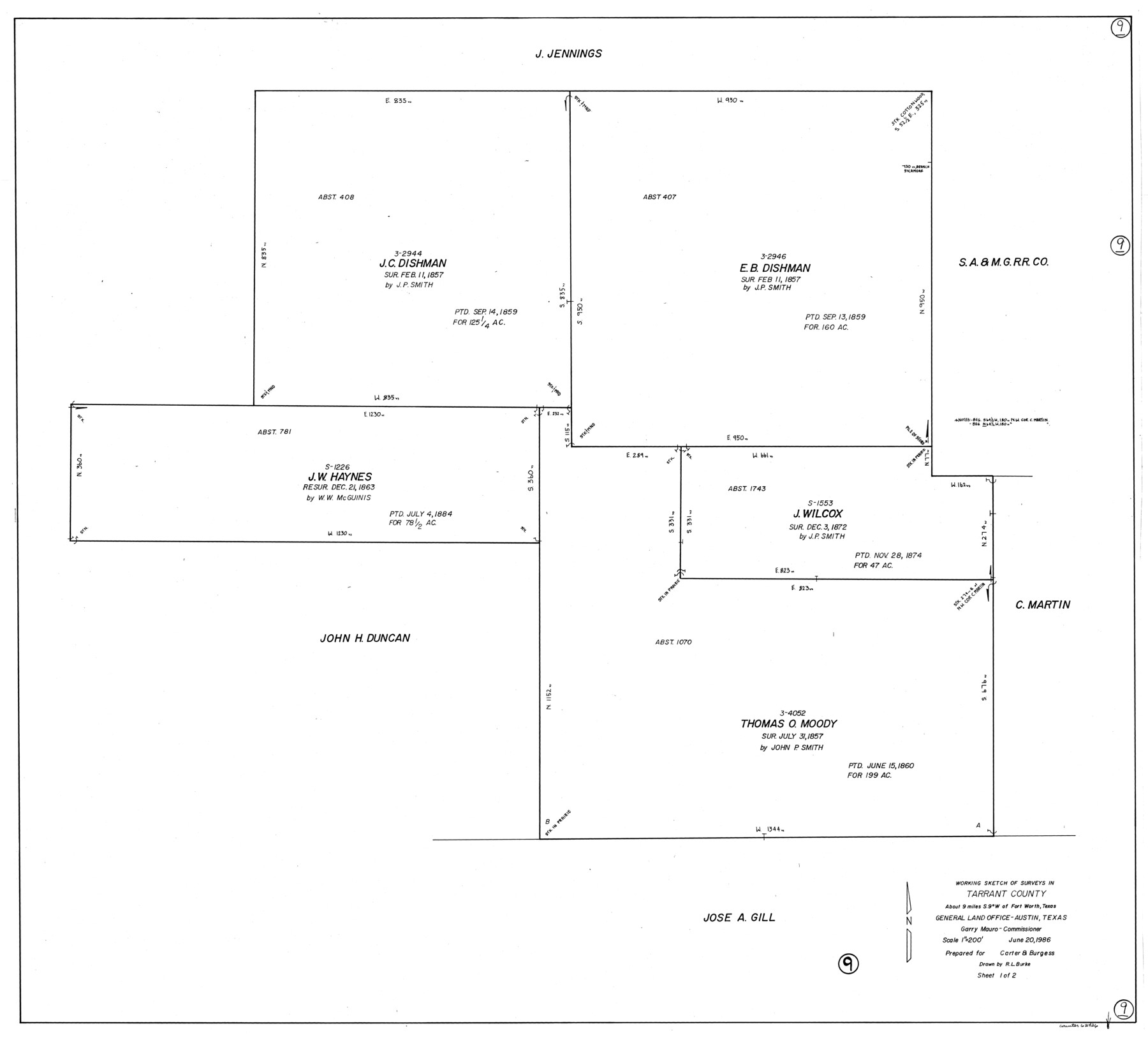
Tarrant County Working Sketch 9
-
Map/Doc
62426
-
Collection
General Map Collection
-
Object Dates
6/20/1986 (Creation Date)
-
People and Organizations
R.L. Burke (Draftsman)
-
Counties
Tarrant
-
Subjects
Surveying Working Sketch
-
Height x Width
38.1 x 42.1 inches
96.8 x 106.9 cm
-
Scale
1" = 200 feet
Part of: General Map Collection
Denton County Boundary File 2

Print $22.00
- Digital $50.00
Denton County Boundary File 2
Size 14.1 x 8.5 inches
Map/Doc 52413
Pecos County Sketch File 79

Print $8.00
- Digital $50.00
Pecos County Sketch File 79
1944
Size 11.3 x 8.8 inches
Map/Doc 33914
Cameron County Aerial Photograph Index Sheet 3

Print $20.00
- Digital $50.00
Cameron County Aerial Photograph Index Sheet 3
1955
Size 21.1 x 17.4 inches
Map/Doc 83675
Brewster County Rolled Sketch 101

Print $20.00
- Digital $50.00
Brewster County Rolled Sketch 101
1944
Size 34.6 x 42.4 inches
Map/Doc 8924
Gillespie County Boundary File 4

Print $56.00
- Digital $50.00
Gillespie County Boundary File 4
Size 13.6 x 9.0 inches
Map/Doc 53754
Nueva Hispania Tabula Nova

Print $20.00
- Digital $50.00
Nueva Hispania Tabula Nova
1561
Size 9.4 x 12.3 inches
Map/Doc 93796
Edwards County Working Sketch 10

Print $20.00
- Digital $50.00
Edwards County Working Sketch 10
1920
Size 21.9 x 18.3 inches
Map/Doc 68886
Montgomery County Rolled Sketch 42

Print $20.00
- Digital $50.00
Montgomery County Rolled Sketch 42
1939
Size 14.1 x 20.1 inches
Map/Doc 6818
Gregg County Rolled Sketch TMB

Print $20.00
- Digital $50.00
Gregg County Rolled Sketch TMB
1931
Size 20.9 x 20.8 inches
Map/Doc 6042
PSL Field Notes for Blocks C13 and C14 in Jeff Davis and Reeves Counties, Block C17 in Culberson and Reeves Counties, and Blocks C11, C12, C15, C16, C18, C19, C20, and C21 in Reeves County

PSL Field Notes for Blocks C13 and C14 in Jeff Davis and Reeves Counties, Block C17 in Culberson and Reeves Counties, and Blocks C11, C12, C15, C16, C18, C19, C20, and C21 in Reeves County
Map/Doc 81672
Flight Mission No. DQN-1K, Frame 111, Calhoun County

Print $20.00
- Digital $50.00
Flight Mission No. DQN-1K, Frame 111, Calhoun County
1953
Size 18.5 x 22.2 inches
Map/Doc 84178
Dimmit County Working Sketch 58

Print $20.00
- Digital $50.00
Dimmit County Working Sketch 58
2017
Size 24.2 x 36.2 inches
Map/Doc 94121
You may also like
Red River Co.

Print $40.00
- Digital $50.00
Red River Co.
1897
Size 48.0 x 39.4 inches
Map/Doc 66993
[Beaumont, Sour Lake and Western Ry. Right of Way and Alignment - Frisco]
![64106, [Beaumont, Sour Lake and Western Ry. Right of Way and Alignment - Frisco], General Map Collection](https://historictexasmaps.com/wmedia_w700/maps/64106.tif.jpg)
Print $20.00
- Digital $50.00
[Beaumont, Sour Lake and Western Ry. Right of Way and Alignment - Frisco]
1910
Size 19.9 x 45.9 inches
Map/Doc 64106
Terry County Sketch File 15

Print $10.00
- Digital $50.00
Terry County Sketch File 15
1944
Size 11.3 x 8.9 inches
Map/Doc 38034
Flight Mission No. BRA-7M, Frame 148, Jefferson County

Print $20.00
- Digital $50.00
Flight Mission No. BRA-7M, Frame 148, Jefferson County
1953
Size 18.6 x 22.4 inches
Map/Doc 85542
Haskell County Boundary File 1

Print $36.00
- Digital $50.00
Haskell County Boundary File 1
Size 8.7 x 9.0 inches
Map/Doc 54518
Burnet County Sketch File 27

Print $4.00
- Digital $50.00
Burnet County Sketch File 27
1874
Size 12.7 x 8.1 inches
Map/Doc 16730
Leon County Rolled Sketch 23

Print $20.00
- Digital $50.00
Leon County Rolled Sketch 23
1981
Size 33.6 x 40.7 inches
Map/Doc 6609
Plat of Jasper, Sabine, San Augustine, Shelby, Harrison and South Part of Nacogdoches Counties

Print $2.00
- Digital $50.00
Plat of Jasper, Sabine, San Augustine, Shelby, Harrison and South Part of Nacogdoches Counties
1841
Size 13.7 x 9.2 inches
Map/Doc 3174
Flight Mission No. DIX-10P, Frame 61, Aransas County

Print $20.00
- Digital $50.00
Flight Mission No. DIX-10P, Frame 61, Aransas County
1956
Size 18.7 x 22.5 inches
Map/Doc 83922
Oldham County Rolled Sketch 11

Print $40.00
- Digital $50.00
Oldham County Rolled Sketch 11
Size 48.6 x 39.9 inches
Map/Doc 10641
Flight Mission No. DQN-3K, Frame 33, Calhoun County

Print $20.00
- Digital $50.00
Flight Mission No. DQN-3K, Frame 33, Calhoun County
1953
Size 18.6 x 22.3 inches
Map/Doc 84346
Dallas County Boundary File 6a

Print $36.00
- Digital $50.00
Dallas County Boundary File 6a
Size 14.0 x 8.6 inches
Map/Doc 52189