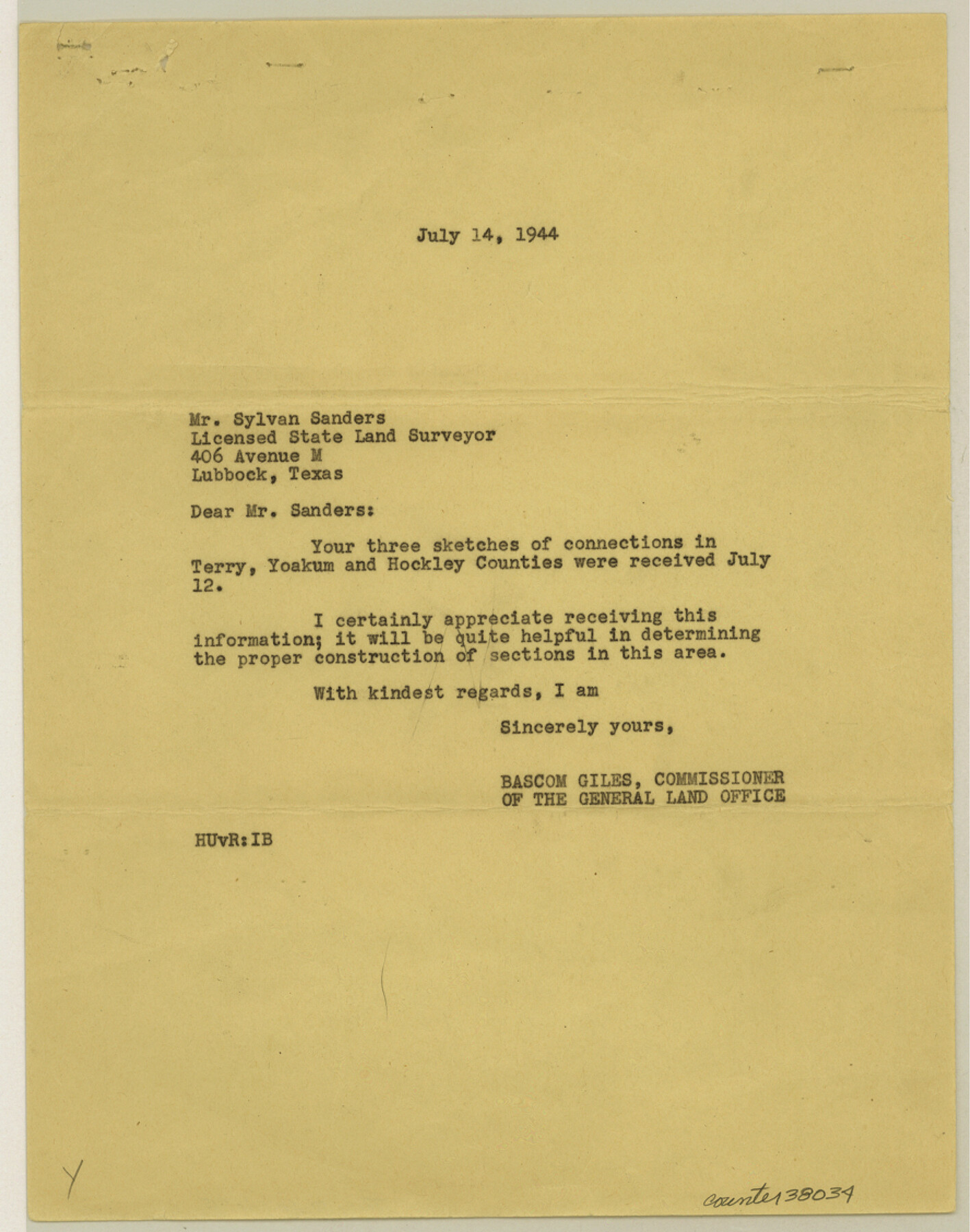
Terry County Sketch File 15
[Sketches of connections in Terry, Yoakum, and Hockley Counties]
- 
                          Map/Doc38034
- 
                            CollectionGeneral Map Collection
- 
                            Object Dates1944 (Creation Date)11/3/1944 (File Date)7/14/1944 (Correspondence Date)
- 
                            People and OrganizationsSylvan Sanders (Surveyor/Engineer)W.J. Williams (Surveyor/Engineer)
- 
                            CountiesTerry Yoakum Hockley
- 
                            SubjectsSurveying Sketch File
- 
                            Height x Width11.3 x 8.9 inches28.7 x 22.6 cm
- 
                            Mediumpaper, print
- 
                            FeaturesCenter Road
Part of: General Map Collection
            Reagan County Sketch File 2A


                                            Print $6.00                    
                                             -                         Digital $50.00                                    
                Reagan County Sketch File 2A
1882
Size 9.1 x 17.6 inches
                                Map/Doc 12211
            
            San Augustine County Texas


                                            Print $20.00                    
                                             -                         Digital $50.00                                    
                San Augustine County Texas
1879
Size 23.8 x 16.9 inches
                                Map/Doc 4623
            
            Territory served by the Galveston Bay Ports, Tex.


                                            Print $20.00                    
                                             -                         Digital $50.00                                    
                Territory served by the Galveston Bay Ports, Tex.
Size 17.1 x 16.0 inches
                                Map/Doc 97165
            
            Flight Mission No. BRA-16M, Frame 117, Jefferson County


                                            Print $20.00                    
                                             -                         Digital $50.00                                    
                Flight Mission No. BRA-16M, Frame 117, Jefferson County
1953
Size 18.7 x 22.1 inches
                                Map/Doc 85727
            
            Jones County Boundary File 2


                                            Print $6.00                    
                                             -                         Digital $50.00                                    
                Jones County Boundary File 2
Size 12.4 x 8.3 inches
                                Map/Doc 55676
            
            Liberty County Working Sketch 49b


                                            Print $20.00                    
                                             -                         Digital $50.00                                    
                Liberty County Working Sketch 49b
1955
Size 28.0 x 31.0 inches
                                Map/Doc 70509
            
            Galveston County NRC Article 33.136 Sketch 23


                                            Print $22.00                    
                                             -                         Digital $50.00                                    
                Galveston County NRC Article 33.136 Sketch 23
2002
Size 11.4 x 16.4 inches
                                Map/Doc 81905
            
            Hutchinson County Working Sketch 16


                                            Print $20.00                    
                                             -                         Digital $50.00                                    
                Hutchinson County Working Sketch 16
1953
Size 23.0 x 36.3 inches
                                Map/Doc 66374
            
            Reagan County Rolled Sketch 11


                                            Print $20.00                    
                                             -                         Digital $50.00                                    
                Reagan County Rolled Sketch 11
1931
Size 20.2 x 39.3 inches
                                Map/Doc 7439
            
            Hutchinson County Sketch File 2


                                            Print $8.00                    
                                             -                         Digital $50.00                                    
                Hutchinson County Sketch File 2
1882
Size 14.2 x 8.7 inches
                                Map/Doc 27173
            
            Tarrant County Boundary File 82


                                            Print $22.00                    
                                             -                         Digital $50.00                                    
                Tarrant County Boundary File 82
Size 8.9 x 7.0 inches
                                Map/Doc 59173
            
            Webb County Rolled Sketch 71


                                            Print $20.00                    
                                             -                         Digital $50.00                                    
                Webb County Rolled Sketch 71
Size 24.2 x 18.5 inches
                                Map/Doc 8218
            You may also like
            Map of Lands Belonging to the Austin & Northern Land & Cattle Co., Coke Co., Texas


                                            Print $20.00                    
                                             -                         Digital $50.00                                    
                Map of Lands Belonging to the Austin & Northern Land & Cattle Co., Coke Co., Texas
Size 23.5 x 19.0 inches
                                Map/Doc 379
            
            Map of Coryell County


                                            Print $20.00                    
                                             -                         Digital $50.00                                    
                Map of Coryell County
1874
Size 22.4 x 26.8 inches
                                Map/Doc 3445
            
            Ellwood Ranch and Adjacent Property in Mitchell, Coke & Sterling Counties, Texas


                                            Print $20.00                    
                                             -                         Digital $50.00                                    
                Ellwood Ranch and Adjacent Property in Mitchell, Coke & Sterling Counties, Texas
1925
Size 17.6 x 27.8 inches
                                Map/Doc 91884
            
            Current Miscellaneous File 15


                                            Print $16.00                    
                                             -                         Digital $50.00                                    
                Current Miscellaneous File 15
1951
Size 10.7 x 8.2 inches
                                Map/Doc 73822
            
            Map Showing a Resurvey of Part of Blk. I, H. &. G. N. Ry. Co. Pecos County, Texas, following field notes copied from Jacob Kuechler's field book of his original survey made in October and November 1876


                                            Print $20.00                    
                                             -                         Digital $50.00                                    
                Map Showing a Resurvey of Part of Blk. I, H. &. G. N. Ry. Co. Pecos County, Texas, following field notes copied from Jacob Kuechler's field book of his original survey made in October and November 1876
1930
Size 19.7 x 14.8 inches
                                Map/Doc 91571
            
            Val Verde County Working Sketch 5


                                            Print $20.00                    
                                             -                         Digital $50.00                                    
                Val Verde County Working Sketch 5
1909
Size 13.0 x 29.8 inches
                                Map/Doc 72140
            
            [Surveys along the Trinity River]
            
                                    ![321, [Surveys along the Trinity River], General Map Collection](https://historictexasmaps.com/wmedia_w700/maps/321.tif.jpg) 


    ![321, [Surveys along the Trinity River], General Map Collection](https://historictexasmaps.com/wmedia_w700/maps/321.tif.jpg) 
                                
            
                                            Print $2.00                    
                                             -                         Digital $50.00                                    
                [Surveys along the Trinity River]
Size 3.6 x 3.7 inches
                                Map/Doc 321
            
            Baylor County Boundary File 10


                                            Print $38.00                    
                                             -                         Digital $50.00                                    
                Baylor County Boundary File 10
Size 9.4 x 7.7 inches
                                Map/Doc 50409
            
            Donley County Sketch File 5


                                            Print $14.00                    
                                             -                         Digital $50.00                                    
                Donley County Sketch File 5
Size 12.9 x 8.5 inches
                                Map/Doc 21223
            
            Flight Mission No. DAG-23K, Frame 163, Matagorda County


                                            Print $20.00                    
                                             -                         Digital $50.00                                    
                Flight Mission No. DAG-23K, Frame 163, Matagorda County
1953
Size 18.6 x 22.4 inches
                                Map/Doc 86501
            
            Map of the Recognised Line M. El. P. & P. R.R. from Texas & Arkansas State Line to Milam & Bexar Land District Line


                                            Print $40.00                    
                                             -                         Digital $50.00                                    
                Map of the Recognised Line M. El. P. & P. R.R. from Texas & Arkansas State Line to Milam & Bexar Land District Line
1856
Size 14.3 x 89.8 inches
                                Map/Doc 64053
             
                            ![4828, [San Diego], General Map Collection](https://historictexasmaps.com/wmedia_w700/maps/4828-1.tif.jpg)