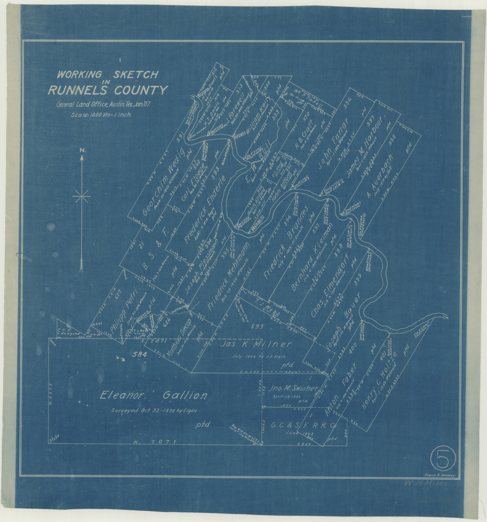
Runnels County Working Sketch 5
- 
                          Map/Doc63601
- 
                            CollectionGeneral Map Collection
- 
                            Object Dates1/1907 (Creation Date)
- 
                            People and OrganizationsFrank R. Sweeney (Draftsman)
- 
                            CountiesRunnels
- 
                            SubjectsSurveying Working Sketch
- 
                            Height x Width17.2 x 16.1 inches43.7 x 40.9 cm
- 
                            Scale1" = 1000 varas
Part of: General Map Collection
            Crockett County Working Sketch 89


                                            Print $20.00                    
                                             -                         Digital $50.00                                    
                Crockett County Working Sketch 89
1978
Size 36.4 x 44.5 inches
                                Map/Doc 68422
            
            Galveston County NRC Article 33.136 Sketch 18


                                            Print $66.00                    
                                             -                         Digital $50.00                                    
                Galveston County NRC Article 33.136 Sketch 18
2003
Size 22.4 x 33.9 inches
                                Map/Doc 78545
            
            Dawson County Sketch File 29


                                            Print $4.00                    
                                             -                         Digital $50.00                                    
                Dawson County Sketch File 29
1892
Size 11.3 x 9.0 inches
                                Map/Doc 20592
            
            Brown County Sketch File 13


                                            Print $40.00                    
                                             -                         Digital $50.00                                    
                Brown County Sketch File 13
Size 17.9 x 33.1 inches
                                Map/Doc 11020
            
            Plat of Resurvey of Sections 13, 24, 25 and 26, T. 5S., R. 12W., of the Indian Meridian, Oklahoma


                                            Print $4.00                    
                                             -                         Digital $50.00                                    
                Plat of Resurvey of Sections 13, 24, 25 and 26, T. 5S., R. 12W., of the Indian Meridian, Oklahoma
1917
Size 18.3 x 24.1 inches
                                Map/Doc 75158
            
            Upton County Working Sketch 32


                                            Print $40.00                    
                                             -                         Digital $50.00                                    
                Upton County Working Sketch 32
1956
Size 55.4 x 37.9 inches
                                Map/Doc 69528
            
            Flight Mission No. CRC-3R, Frame 18, Chambers County


                                            Print $20.00                    
                                             -                         Digital $50.00                                    
                Flight Mission No. CRC-3R, Frame 18, Chambers County
1956
Size 18.7 x 22.4 inches
                                Map/Doc 84792
            
            Brewster County Rolled Sketch 101


                                            Print $40.00                    
                                             -                         Digital $50.00                                    
                Brewster County Rolled Sketch 101
1927
Size 74.4 x 42.4 inches
                                Map/Doc 9196
            
            Crane County Sketch File 18


                                            Print $20.00                    
                                             -                         Digital $50.00                                    
                Crane County Sketch File 18
1927
Size 15.1 x 18.4 inches
                                Map/Doc 11210
            
            Harris County Working Sketch 31


                                            Print $20.00                    
                                             -                         Digital $50.00                                    
                Harris County Working Sketch 31
1936
Size 27.7 x 22.0 inches
                                Map/Doc 65923
            You may also like
            Jasper County Sketch File 31


                                            Print $20.00                    
                                             -                         Digital $50.00                                    
                Jasper County Sketch File 31
Size 21.6 x 24.7 inches
                                Map/Doc 11852
            
            Edwards County Working Sketch 117


                                            Print $20.00                    
                                             -                         Digital $50.00                                    
                Edwards County Working Sketch 117
1974
Size 31.4 x 44.1 inches
                                Map/Doc 68993
            
            Sterling County Sketch File 1


                                            Print $40.00                    
                                             -                         Digital $50.00                                    
                Sterling County Sketch File 1
1862
Size 18.7 x 8.4 inches
                                Map/Doc 37111
            
            [Terry County Highways]
            
                                    ![92905, [Terry County Highways], Twichell Survey Records](https://historictexasmaps.com/wmedia_w700/maps/92905-1.tif.jpg) 


    ![92905, [Terry County Highways], Twichell Survey Records](https://historictexasmaps.com/wmedia_w700/maps/92905-1.tif.jpg) 
                                
            
                                            Print $20.00                    
                                             -                         Digital $50.00                                    
                [Terry County Highways]
Size 17.0 x 16.8 inches
                                Map/Doc 92905
            
            Terrell County Rolled Sketch 19A


                                            Print $20.00                    
                                             -                         Digital $50.00                                    
                Terrell County Rolled Sketch 19A
1886
Size 19.8 x 11.1 inches
                                Map/Doc 7928
            
            Stonewall County Working Sketch 33


                                            Print $40.00                    
                                             -                         Digital $50.00                                    
                Stonewall County Working Sketch 33
1984
Size 70.4 x 42.8 inches
                                Map/Doc 62340
            
            Map of Texas with population and location of principal towns and cities according to latest reliable statistics


                                            Print $20.00                    
                                             -                         Digital $50.00                                    
                Map of Texas with population and location of principal towns and cities according to latest reliable statistics
1921
Size 19.0 x 22.2 inches
                                Map/Doc 94066
            
            Val Verde County Sketch File 51


                                            Print $10.00                    
                                             -                         Digital $50.00                                    
                Val Verde County Sketch File 51
1959
Size 9.8 x 8.7 inches
                                Map/Doc 39320
            
            Houston County Sketch File 7a


                                            Print $4.00                    
                                             -                         Digital $50.00                                    
                Houston County Sketch File 7a
Size 7.6 x 8.2 inches
                                Map/Doc 26766
            
            [Sketch focused on Southeast corner of Lubbock County]
            
                                    ![89899, [Sketch focused on Southeast corner of Lubbock County], Twichell Survey Records](https://historictexasmaps.com/wmedia_w700/maps/89899-1.tif.jpg) 


    ![89899, [Sketch focused on Southeast corner of Lubbock County], Twichell Survey Records](https://historictexasmaps.com/wmedia_w700/maps/89899-1.tif.jpg) 
                                
            
                                            Print $20.00                    
                                             -                         Digital $50.00                                    
                [Sketch focused on Southeast corner of Lubbock County]
Size 42.8 x 36.9 inches
                                Map/Doc 89899


                                ![94181, San Antonio [Recto], General Map Collection](https://historictexasmaps.com/wmedia_w700/maps/94181.tif.jpg)