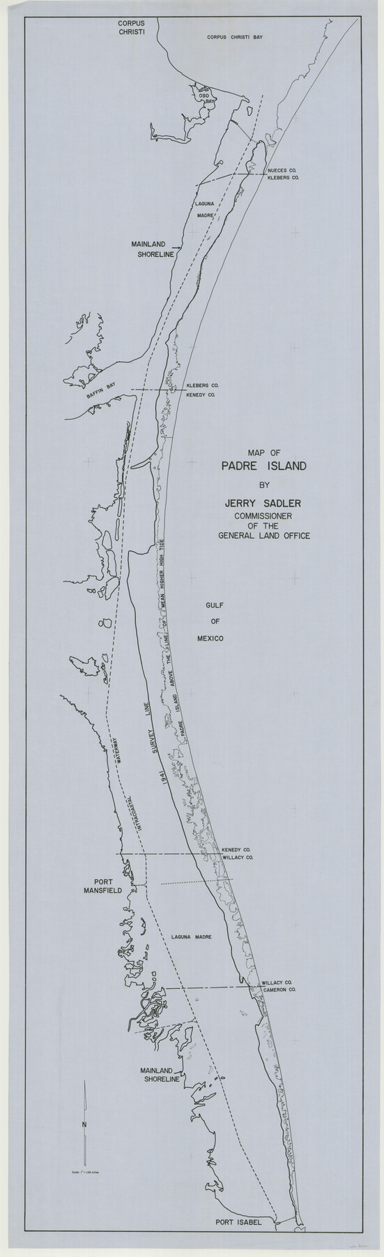
Map of Padre Island
-
Map/Doc
76020
-
Collection
General Map Collection
-
Subjects
Gulf of Mexico
-
Height x Width
74.6 x 22.8 inches
189.5 x 57.9 cm
Part of: General Map Collection
Palo Pinto County Rolled Sketch 9

Print $40.00
- Digital $50.00
Palo Pinto County Rolled Sketch 9
Size 78.0 x 30.9 inches
Map/Doc 9675
Morris County Rolled Sketch 2A

Print $20.00
- Digital $50.00
Morris County Rolled Sketch 2A
Size 24.3 x 19.1 inches
Map/Doc 10241
Kent County Working Sketch 3b

Print $20.00
- Digital $50.00
Kent County Working Sketch 3b
1948
Size 24.9 x 23.3 inches
Map/Doc 70010
Dimmit County Working Sketch 35

Print $20.00
- Digital $50.00
Dimmit County Working Sketch 35
1961
Size 22.4 x 24.4 inches
Map/Doc 68696
Kent County Working Sketch 15

Print $40.00
- Digital $50.00
Kent County Working Sketch 15
1971
Size 32.3 x 48.3 inches
Map/Doc 70022
Flight Mission No. DIX-8P, Frame 66, Aransas County

Print $20.00
- Digital $50.00
Flight Mission No. DIX-8P, Frame 66, Aransas County
1956
Size 18.6 x 22.2 inches
Map/Doc 83897
Matagorda Light to Aransas Pass

Print $20.00
- Digital $50.00
Matagorda Light to Aransas Pass
1972
Size 35.9 x 44.8 inches
Map/Doc 73400
Jasper County Sketch File 10

Print $4.00
- Digital $50.00
Jasper County Sketch File 10
1878
Size 9.1 x 8.6 inches
Map/Doc 27788
Flight Mission No. DQO-3K, Frame 36, Galveston County

Print $20.00
- Digital $50.00
Flight Mission No. DQO-3K, Frame 36, Galveston County
1952
Size 18.7 x 22.4 inches
Map/Doc 85077
Kerr County Sketch File 8

Print $4.00
- Digital $50.00
Kerr County Sketch File 8
1882
Size 12.6 x 8.1 inches
Map/Doc 28871
Sutton County Sketch File 56

Print $8.00
Sutton County Sketch File 56
1953
Size 11.2 x 9.0 inches
Map/Doc 37538
Kimble County Working Sketch 40

Print $40.00
- Digital $50.00
Kimble County Working Sketch 40
1948
Size 53.0 x 38.4 inches
Map/Doc 70108
You may also like
Gaines County Sketch File 19

Print $8.00
- Digital $50.00
Gaines County Sketch File 19
1989
Size 11.3 x 8.8 inches
Map/Doc 23331
Motley County Sketch File 16 (N)

Print $16.00
- Digital $50.00
Motley County Sketch File 16 (N)
1911
Size 11.0 x 8.6 inches
Map/Doc 32052
Real County Working Sketch 1

Print $20.00
- Digital $50.00
Real County Working Sketch 1
Size 16.5 x 18.8 inches
Map/Doc 71893
Grimes County Sketch File 4

Print $4.00
- Digital $50.00
Grimes County Sketch File 4
1872
Size 12.7 x 8.0 inches
Map/Doc 24635
Concho County Sketch File 16

Print $20.00
- Digital $50.00
Concho County Sketch File 16
Size 8.2 x 18.6 inches
Map/Doc 11151
Working Sketch Crosby, Garza, Lynn, and Lubbock Counties

Print $20.00
- Digital $50.00
Working Sketch Crosby, Garza, Lynn, and Lubbock Counties
1904
Size 34.3 x 36.4 inches
Map/Doc 92695
Trinity County Sketch File 42

Print $60.00
- Digital $50.00
Trinity County Sketch File 42
1858
Size 28.0 x 37.6 inches
Map/Doc 10409
Map of Wharton County

Print $40.00
- Digital $50.00
Map of Wharton County
1895
Size 48.2 x 53.8 inches
Map/Doc 82055
Cooke County Working Sketch 21

Print $20.00
- Digital $50.00
Cooke County Working Sketch 21
1959
Size 35.3 x 30.3 inches
Map/Doc 68258
Flight Mission No. CRC-2R, Frame 195, Chambers County

Print $20.00
- Digital $50.00
Flight Mission No. CRC-2R, Frame 195, Chambers County
1956
Size 18.6 x 22.3 inches
Map/Doc 84773
Starr County Rolled Sketch 24

Print $20.00
- Digital $50.00
Starr County Rolled Sketch 24
1938
Size 37.5 x 26.7 inches
Map/Doc 7808
Dimmit County Working Sketch 54

Print $20.00
- Digital $50.00
Dimmit County Working Sketch 54
1996
Size 27.8 x 30.0 inches
Map/Doc 68715