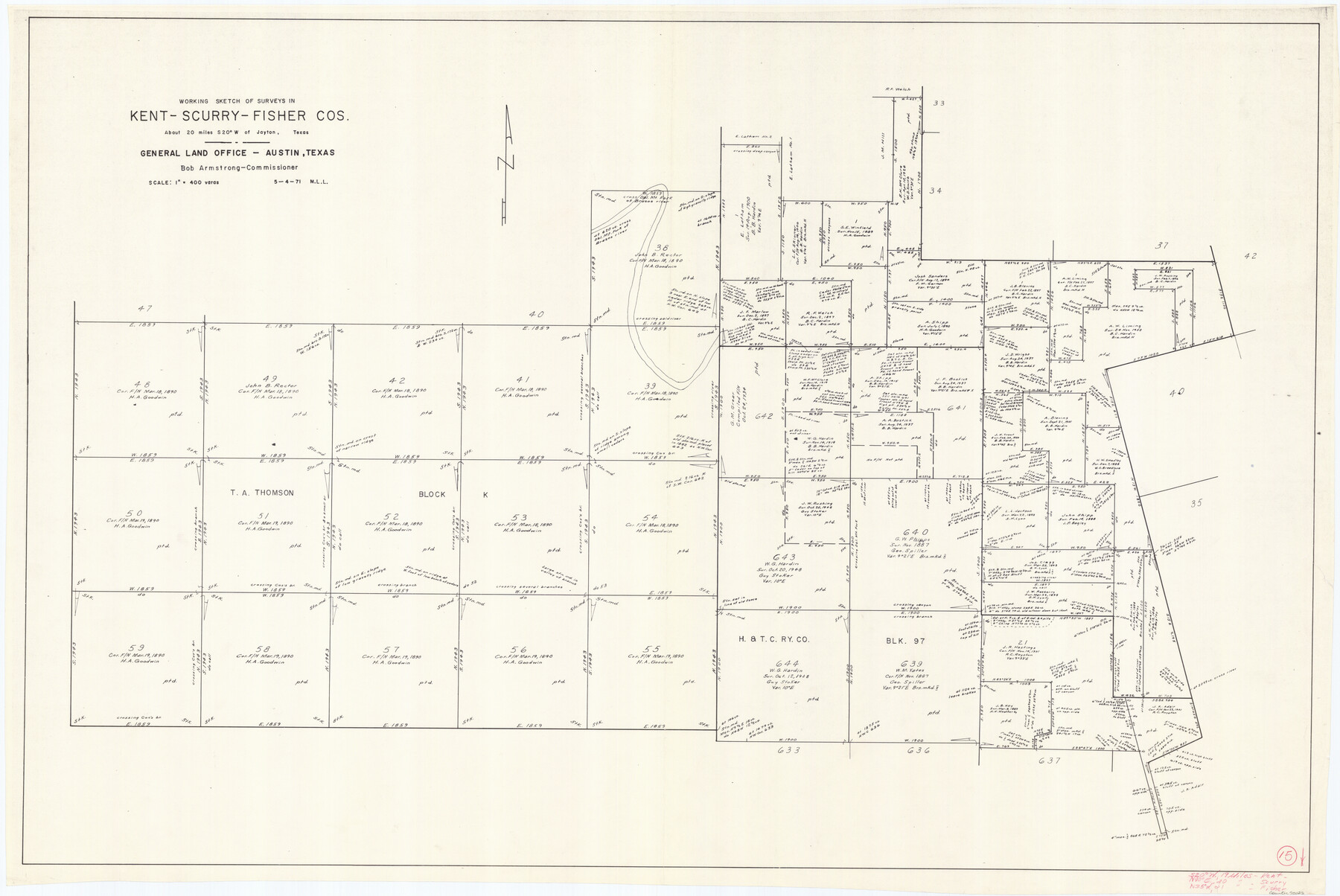
Kent County Working Sketch 15
-
Map/Doc
70022
-
Collection
General Map Collection
-
Object Dates
5/4/1971 (Creation Date)
-
People and Organizations
M. L. Liles (Draftsman)
-
Counties
Kent Scurry Fisher
-
Subjects
Surveying Working Sketch
-
Height x Width
32.3 x 48.3 inches
82.0 x 122.7 cm
-
Scale
1" = 400 varas
Part of: General Map Collection
Galveston County Sketch File 6

Print $4.00
- Digital $50.00
Galveston County Sketch File 6
Size 14.2 x 8.9 inches
Map/Doc 23362
Upshur County Sketch File 13

Print $4.00
- Digital $50.00
Upshur County Sketch File 13
1861
Size 8.2 x 8.3 inches
Map/Doc 38755
Bandera County Working Sketch 22

Print $20.00
- Digital $50.00
Bandera County Working Sketch 22
1949
Size 42.8 x 24.9 inches
Map/Doc 67618
Travis County Working Sketch 53

Print $40.00
- Digital $50.00
Travis County Working Sketch 53
1964
Size 42.7 x 53.0 inches
Map/Doc 69437
Johnson County Working Sketch 15

Print $20.00
- Digital $50.00
Johnson County Working Sketch 15
1974
Size 21.6 x 23.8 inches
Map/Doc 66628
Map showing connection of land-lines with M. & P. E. Ry. through Uvalde Co.

Print $40.00
- Digital $50.00
Map showing connection of land-lines with M. & P. E. Ry. through Uvalde Co.
1882
Size 11.8 x 86.3 inches
Map/Doc 64179
Motley County Sketch File 18 (N)

Print $4.00
- Digital $50.00
Motley County Sketch File 18 (N)
1913
Size 11.3 x 8.7 inches
Map/Doc 32062
Jasper County Working Sketch 20

Print $20.00
- Digital $50.00
Jasper County Working Sketch 20
1940
Size 27.2 x 45.0 inches
Map/Doc 66482
Aransas Pass to Baffin Bay

Print $20.00
- Digital $50.00
Aransas Pass to Baffin Bay
1986
Size 44.7 x 35.7 inches
Map/Doc 73421
Val Verde County Sketch File D

Print $20.00
- Digital $50.00
Val Verde County Sketch File D
1899
Size 29.8 x 40.0 inches
Map/Doc 10422
Map of Dallas & Greenville Railroad through Dallas County, Texas

Print $2.00
- Digital $50.00
Map of Dallas & Greenville Railroad through Dallas County, Texas
Size 14.8 x 4.5 inches
Map/Doc 64487
Castro County Boundary File 1b

Print $32.00
- Digital $50.00
Castro County Boundary File 1b
Size 14.1 x 8.6 inches
Map/Doc 51208
You may also like
Flight Mission No. BQY-4M, Frame 30, Harris County

Print $20.00
- Digital $50.00
Flight Mission No. BQY-4M, Frame 30, Harris County
1953
Size 18.7 x 22.4 inches
Map/Doc 85245
General Highway Map, Burleson County, Texas

Print $20.00
General Highway Map, Burleson County, Texas
1961
Size 18.1 x 24.8 inches
Map/Doc 79391
Coast Chart No. 211 - Padre I. and Laguna Madre Lat. 27° 12' to Lat. 26° 33' Texas

Print $20.00
- Digital $50.00
Coast Chart No. 211 - Padre I. and Laguna Madre Lat. 27° 12' to Lat. 26° 33' Texas
1890
Size 27.5 x 18.2 inches
Map/Doc 72824
[Surveys along the Leon River and Plum Creek]
![255, [Surveys along the Leon River and Plum Creek], General Map Collection](https://historictexasmaps.com/wmedia_w700/maps/255.tif.jpg)
Print $2.00
- Digital $50.00
[Surveys along the Leon River and Plum Creek]
1846
Size 11.7 x 7.6 inches
Map/Doc 255
Sylvan Sander's Map of Lubbock, Hockley, and Cochran Counties, Texas

Print $20.00
- Digital $50.00
Sylvan Sander's Map of Lubbock, Hockley, and Cochran Counties, Texas
1925
Size 43.6 x 21.8 inches
Map/Doc 92611
Flight Mission No. DQO-3K, Frame 32, Galveston County

Print $20.00
- Digital $50.00
Flight Mission No. DQO-3K, Frame 32, Galveston County
1952
Size 18.7 x 22.5 inches
Map/Doc 85073
Flight Mission No. CLL-4N, Frame 32, Willacy County

Print $20.00
- Digital $50.00
Flight Mission No. CLL-4N, Frame 32, Willacy County
1954
Size 18.5 x 22.1 inches
Map/Doc 87105
Cameron County Rolled Sketch 25

Print $20.00
- Digital $50.00
Cameron County Rolled Sketch 25
1977
Size 24.7 x 36.7 inches
Map/Doc 5795
Flight Mission No. BRA-3M, Frame 122, Jefferson County

Print $20.00
- Digital $50.00
Flight Mission No. BRA-3M, Frame 122, Jefferson County
1953
Size 18.7 x 22.3 inches
Map/Doc 85396
Map of Jackson County Texas

Print $20.00
- Digital $50.00
Map of Jackson County Texas
1840
Size 29.6 x 23.2 inches
Map/Doc 3708
General Highway Map, Williamson County, Texas

Print $20.00
General Highway Map, Williamson County, Texas
1961
Size 24.8 x 18.2 inches
Map/Doc 79712
Karte von Indian Point od Indianola / Karte der Stadt Neu Braunfels / Karte der Stadt Friedrichsburg / Hafen von Indian Point oder Indianola

Print $20.00
- Digital $50.00
Karte von Indian Point od Indianola / Karte der Stadt Neu Braunfels / Karte der Stadt Friedrichsburg / Hafen von Indian Point oder Indianola
1850
Size 13.6 x 19.4 inches
Map/Doc 2182