Gaines County Sketch File 19
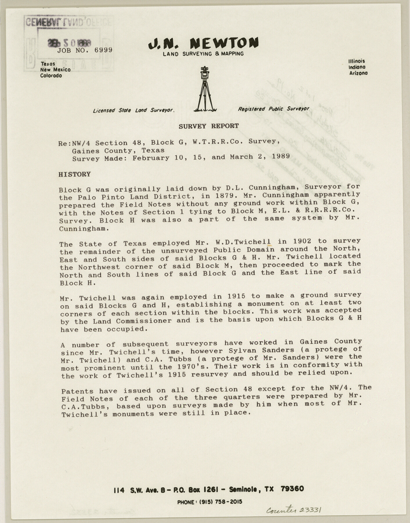
[Survey report of northwest 1/4 of section 48, Block G, W. T. R.R. Co]
-
Map/Doc
23331
-
Collection
General Map Collection
-
Object Dates
1989/9/14 (Creation Date)
1989/9/20 (File Date)
1989/2/15 (Survey Date)
1989/3/2 (Survey Date)
1902 (Survey Date)
1915 (Survey Date)
1960 (Survey Date)
-
People and Organizations
J.N. Newton (Surveyor/Engineer)
W.D. Twichell (Surveyor/Engineer)
Sylvan Sanders (Surveyor/Engineer)
C.A. Tubbs (Surveyor/Engineer)
-
Counties
Gaines
-
Subjects
Surveying Sketch File
-
Height x Width
11.3 x 8.8 inches
28.7 x 22.4 cm
-
Medium
paper, print
-
Comments
See Gaines County Rolled Sketch 28 (5941) for sketch.
Related maps
Gaines County Rolled Sketch 28

Print $20.00
- Digital $50.00
Gaines County Rolled Sketch 28
1989
Size 25.6 x 19.7 inches
Map/Doc 5941
Part of: General Map Collection
Map of a portion of the City of Galveston, Texas showing proposed location of Sea Wall and Right of Way to be obtained

Print $20.00
- Digital $50.00
Map of a portion of the City of Galveston, Texas showing proposed location of Sea Wall and Right of Way to be obtained
1902
Size 16.5 x 38.5 inches
Map/Doc 73625

Yoakum County Rolled Sketch 3(2)

Print $40.00
- Digital $50.00
Yoakum County Rolled Sketch 3(2)
1959
Size 12.4 x 104.3 inches
Map/Doc 76041
Hardin County Rolled Sketch 13

Print $20.00
- Digital $50.00
Hardin County Rolled Sketch 13
Size 36.0 x 42.3 inches
Map/Doc 9187

Kimble County Sketch File 35

Print $16.00
- Digital $50.00
Kimble County Sketch File 35
1963
Size 11.2 x 8.7 inches
Map/Doc 28982
Hudspeth County Sketch File 25

Print $10.00
- Digital $50.00
Hudspeth County Sketch File 25
1936
Size 11.3 x 8.7 inches
Map/Doc 26979
Kimble County Working Sketch 64

Print $20.00
- Digital $50.00
Kimble County Working Sketch 64
1964
Size 15.1 x 16.9 inches
Map/Doc 70132
Hockley County Boundary File 5

Print $42.00
- Digital $50.00
Hockley County Boundary File 5
Size 6.8 x 5.8 inches
Map/Doc 54829
Oldham County Boundary File 1a

Print $62.00
- Digital $50.00
Oldham County Boundary File 1a
Size 13.0 x 8.1 inches
Map/Doc 57734
[Galveston, Harrisburg & San Antonio through El Paso County]
![64004, [Galveston, Harrisburg & San Antonio through El Paso County], General Map Collection](https://historictexasmaps.com/wmedia_w700/maps/64004.tif.jpg)
Print $20.00
- Digital $50.00
[Galveston, Harrisburg & San Antonio through El Paso County]
Size 13.6 x 33.6 inches
Map/Doc 64004
Harris County Working Sketch 30

Print $20.00
- Digital $50.00
Harris County Working Sketch 30
1935
Size 25.9 x 28.0 inches
Map/Doc 65922
You may also like
Flight Mission No. CGI-4N, Frame 193, Cameron County

Print $20.00
- Digital $50.00
Flight Mission No. CGI-4N, Frame 193, Cameron County
1955
Size 18.6 x 22.3 inches
Map/Doc 84696
Flight Mission No. DCL-7C, Frame 71, Kenedy County

Print $20.00
- Digital $50.00
Flight Mission No. DCL-7C, Frame 71, Kenedy County
1943
Size 15.5 x 15.1 inches
Map/Doc 86057
Kleberg County Boundary File 1

Print $10.00
- Digital $50.00
Kleberg County Boundary File 1
Size 9.3 x 5.9 inches
Map/Doc 64961
North Part Brewster Co.

Print $40.00
- Digital $50.00
North Part Brewster Co.
1914
Size 40.6 x 49.2 inches
Map/Doc 66729
G. T. Oliver's Subdivisions of the Motley and Foard County School Leagues situated in Bailey County, Texas

Print $20.00
- Digital $50.00
G. T. Oliver's Subdivisions of the Motley and Foard County School Leagues situated in Bailey County, Texas
1909
Size 24.6 x 37.4 inches
Map/Doc 92534
Map of Milam County

Print $40.00
- Digital $50.00
Map of Milam County
1839
Size 54.5 x 45.9 inches
Map/Doc 3881
Plat of Section No. 44, Blk. No. 4, T. & P. RR. Co. showing subdivisions of same with 3.1 acre survey made for W. D. Twichell

Print $2.00
- Digital $50.00
Plat of Section No. 44, Blk. No. 4, T. & P. RR. Co. showing subdivisions of same with 3.1 acre survey made for W. D. Twichell
1919
Size 8.9 x 13.3 inches
Map/Doc 91908
La Salle County Rolled Sketch 2

Print $20.00
- Digital $50.00
La Salle County Rolled Sketch 2
1915
Size 25.2 x 23.2 inches
Map/Doc 6567
[Surveys in the Bexar District along the Guadalupe River and Cibolo Creek]
![3169, [Surveys in the Bexar District along the Guadalupe River and Cibolo Creek], General Map Collection](https://historictexasmaps.com/wmedia_w700/maps/3169.tif.jpg)
Print $20.00
- Digital $50.00
[Surveys in the Bexar District along the Guadalupe River and Cibolo Creek]
1846
Size 9.6 x 18.3 inches
Map/Doc 3169

Stonewall County Working Sketch 20

Print $20.00
- Digital $50.00
Stonewall County Working Sketch 20
1961
Size 33.3 x 40.0 inches
Map/Doc 62327
Bandera County Sketch File 32

Print $52.00
- Digital $50.00
Bandera County Sketch File 32
1966
Size 23.6 x 20.0 inches
Map/Doc 10901