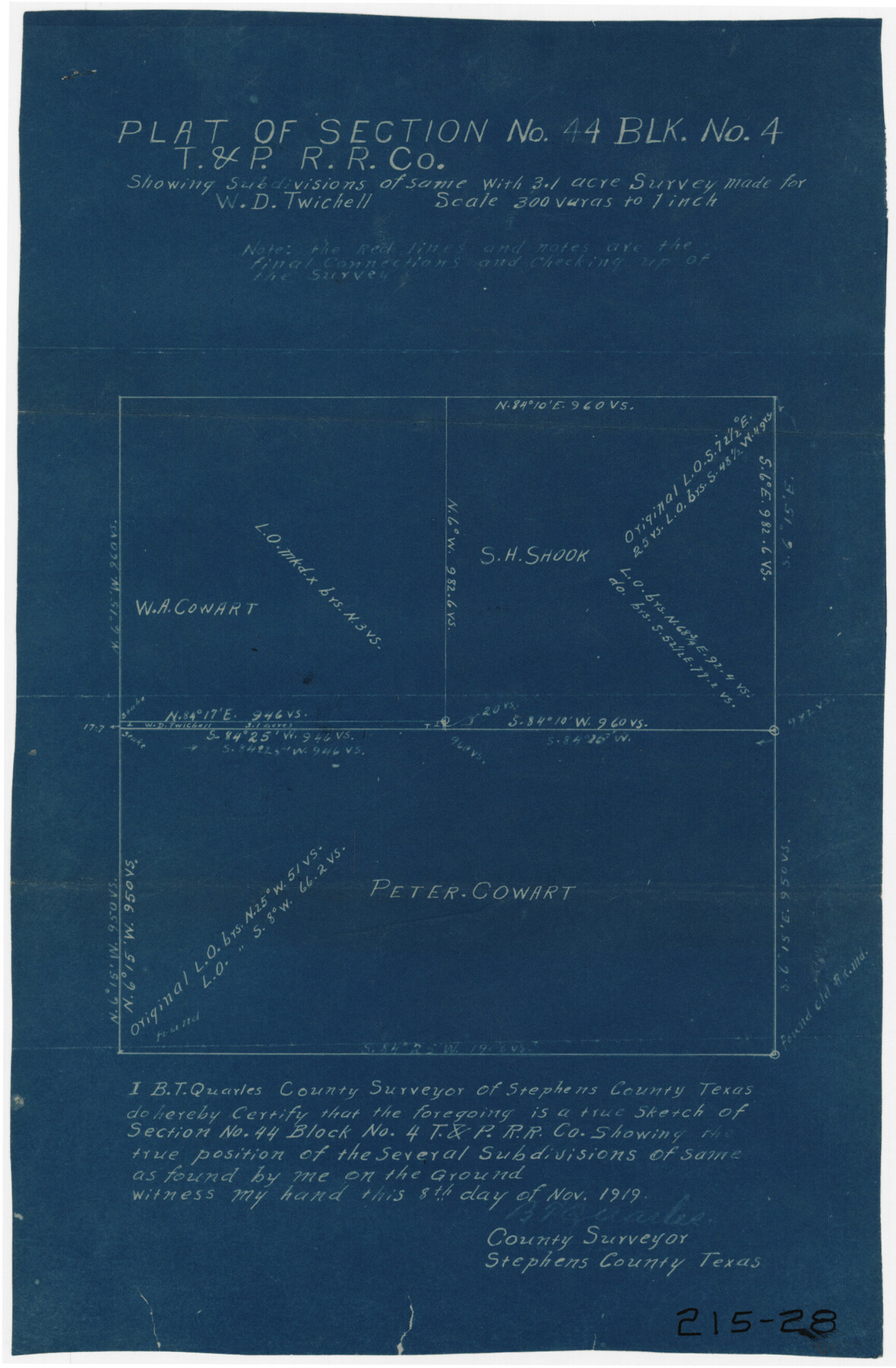
Plat of Section No. 44, Blk. No. 4, T. & P. RR. Co. showing subdivisions of same with 3.1 acre survey made for W. D. Twichell
215-28
-
Map/Doc
91908
-
Collection
Twichell Survey Records
-
Object Dates
1919/11/8 (Creation Date)
-
People and Organizations
B.T. Quarles (Surveyor/Engineer)
-
Counties
Stephens
-
Height x Width
8.9 x 13.3 inches
22.6 x 33.8 cm
Part of: Twichell Survey Records
Map A [showing surveys along river and in vicinity of Archer County School Land League 3]
![89751, Map A [showing surveys along river and in vicinity of Archer County School Land League 3], Twichell Survey Records](https://historictexasmaps.com/wmedia_w700/maps/89751-1.tif.jpg)
Print $20.00
- Digital $50.00
Map A [showing surveys along river and in vicinity of Archer County School Land League 3]
Size 42.3 x 38.0 inches
Map/Doc 89751
John B. Slaughter Ranch Situated in Garza County, Texas

Print $20.00
- Digital $50.00
John B. Slaughter Ranch Situated in Garza County, Texas
Size 32.5 x 44.7 inches
Map/Doc 92657
[Blocks P, D, and John H. Gibson]
![90446, [Blocks P, D, and John H. Gibson], Twichell Survey Records](https://historictexasmaps.com/wmedia_w700/maps/90446-2.tif.jpg)
Print $20.00
- Digital $50.00
[Blocks P, D, and John H. Gibson]
Size 28.2 x 19.5 inches
Map/Doc 90446
Plat of Land Purchased by C. W. Post in Hockley County, Texas

Print $20.00
- Digital $50.00
Plat of Land Purchased by C. W. Post in Hockley County, Texas
1913
Size 24.1 x 14.5 inches
Map/Doc 91116
[Sketch showing Potter County Block 2] / [Sketch showing F. W. & D. C. Round House]
![91710, [Sketch showing Potter County Block 2] / [Sketch showing F. W. & D. C. Round House], Twichell Survey Records](https://historictexasmaps.com/wmedia_w700/maps/91710-1.tif.jpg)
Print $20.00
- Digital $50.00
[Sketch showing Potter County Block 2] / [Sketch showing F. W. & D. C. Round House]
Size 14.6 x 12.1 inches
Map/Doc 91710
[Connections of Blocks C-17, B-59, T6 and C-11]
![93067, [Connections of Blocks C-17, B-59, T6 and C-11], Twichell Survey Records](https://historictexasmaps.com/wmedia_w700/maps/93067-1.tif.jpg)
Print $20.00
- Digital $50.00
[Connections of Blocks C-17, B-59, T6 and C-11]
Size 31.2 x 28.0 inches
Map/Doc 93067
Section D Tech Memorial Park, Inc.

Print $20.00
- Digital $50.00
Section D Tech Memorial Park, Inc.
Size 19.0 x 20.5 inches
Map/Doc 92300
R. S. Coon's Blue Creek Ranch, Moore County, Texas

Print $20.00
- Digital $50.00
R. S. Coon's Blue Creek Ranch, Moore County, Texas
Size 15.8 x 15.7 inches
Map/Doc 91487
![91233, [Block R], Twichell Survey Records](https://historictexasmaps.com/wmedia_w700/maps/91233-1.tif.jpg)
"K" Sketch from Loving & Winkler Counties

Print $40.00
- Digital $50.00
"K" Sketch from Loving & Winkler Counties
1902
Size 49.4 x 39.7 inches
Map/Doc 89938
Map of the Capitol Land Reservation

Print $40.00
- Digital $50.00
Map of the Capitol Land Reservation
Size 26.3 x 49.5 inches
Map/Doc 92042
[Points along west and north lines of county]
![90401, [Points along west and north lines of county], Twichell Survey Records](https://historictexasmaps.com/wmedia_w700/maps/90401-1.tif.jpg)
Print $20.00
- Digital $50.00
[Points along west and north lines of county]
Size 14.7 x 19.3 inches
Map/Doc 90401
You may also like
San Patricio County Sketch File 15A

Print $4.00
San Patricio County Sketch File 15A
1883
Size 11.0 x 8.5 inches
Map/Doc 97195
Moore County Sketch File 5

Print $22.00
- Digital $50.00
Moore County Sketch File 5
Size 9.0 x 12.6 inches
Map/Doc 31937
[St. Louis & Southwestern]
![64279, [St. Louis & Southwestern], General Map Collection](https://historictexasmaps.com/wmedia_w700/maps/64279.tif.jpg)
Print $20.00
- Digital $50.00
[St. Louis & Southwestern]
Size 20.7 x 28.5 inches
Map/Doc 64279
Sherman County Sketch File 8

Print $61.00
- Digital $50.00
Sherman County Sketch File 8
1993
Size 11.4 x 8.9 inches
Map/Doc 36726
Angelina County Sketch File 12

Print $4.00
- Digital $50.00
Angelina County Sketch File 12
1860
Size 14.1 x 8.1 inches
Map/Doc 12955
Travis County Appraisal District Plat Map 2_0603

Print $20.00
- Digital $50.00
Travis County Appraisal District Plat Map 2_0603
Size 21.5 x 26.4 inches
Map/Doc 94233
Dimmit County Sketch File 41

Print $4.00
- Digital $50.00
Dimmit County Sketch File 41
1901
Size 14.6 x 9.1 inches
Map/Doc 21169
Hunt County Sketch File 29

Print $4.00
- Digital $50.00
Hunt County Sketch File 29
Size 7.4 x 7.8 inches
Map/Doc 27130
[L. C. Dennison and other surveys to the east, south of the south line of T. & P. Blocks 4 and 6]
![93050, [L. C. Dennison and other surveys to the east, south of the south line of T. & P. Blocks 4 and 6], Twichell Survey Records](https://historictexasmaps.com/wmedia_w700/maps/93050-1.tif.jpg)
Print $20.00
- Digital $50.00
[L. C. Dennison and other surveys to the east, south of the south line of T. & P. Blocks 4 and 6]
1919
Size 32.1 x 17.6 inches
Map/Doc 93050
Erath County Working Sketch 9

Print $20.00
- Digital $50.00
Erath County Working Sketch 9
1939
Size 18.6 x 14.8 inches
Map/Doc 69090
Jefferson County Working Sketch 8

Print $20.00
- Digital $50.00
Jefferson County Working Sketch 8
1931
Size 34.9 x 18.2 inches
Map/Doc 66551
Brazos River Conservation and Reclamation District Official Boundary Line Survey

Print $20.00
- Digital $50.00
Brazos River Conservation and Reclamation District Official Boundary Line Survey
Size 37.0 x 25.0 inches
Map/Doc 90130