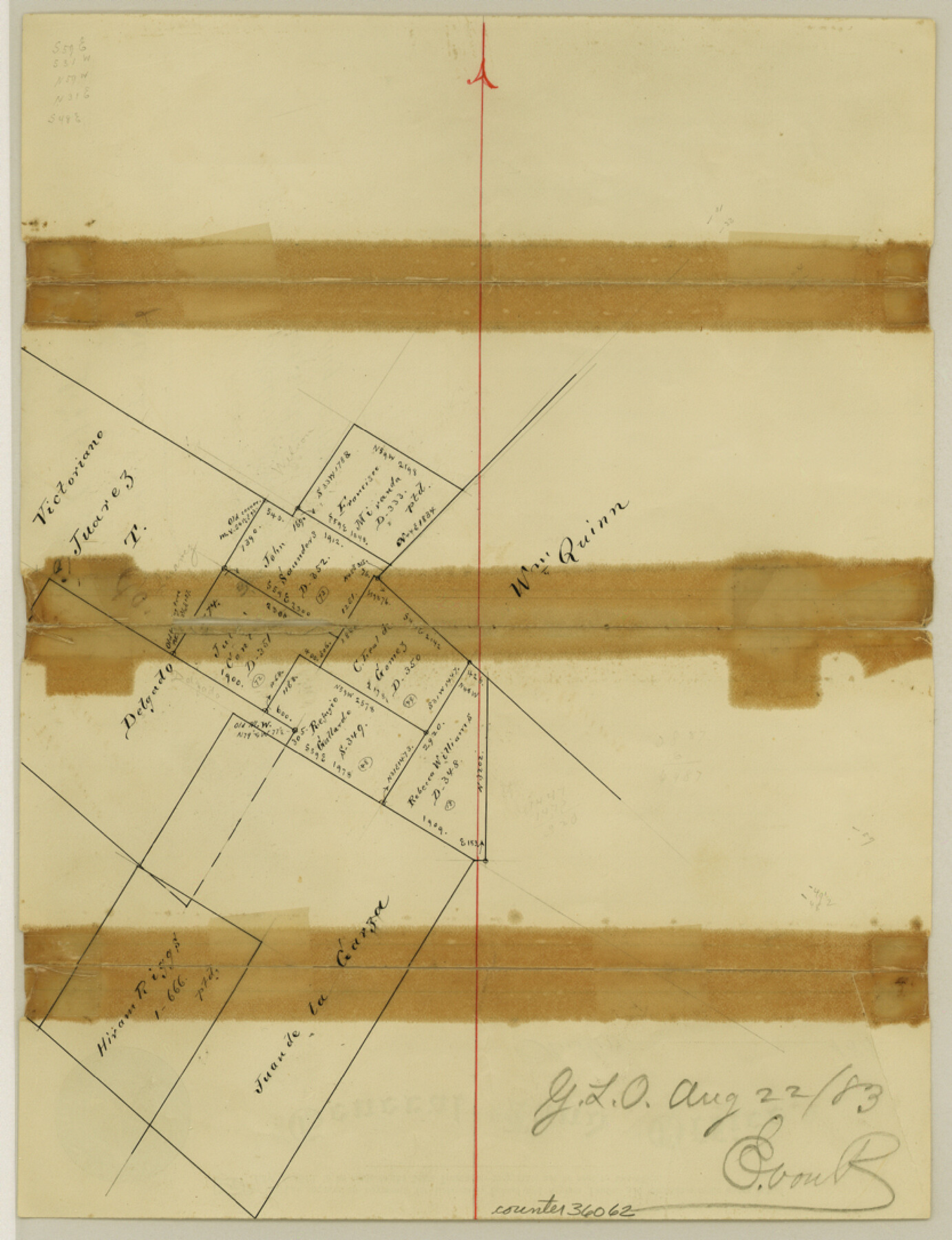
San Patricio County Sketch File 15A
[Office sketch of surveys between the Victoriano Juarez and Wm. Quinn surveys in the northwest part of the county]
-
Map/Doc
97195
-
Collection
General Map Collection
-
Object Dates
8/22/1883 (Creation Date)
-
People and Organizations
E. von Rosenberg (Draftsman)
-
Counties
San Patricio
-
Subjects
Surveying Sketch File
-
Height x Width
11.0 x 8.5 inches
27.9 x 21.6 cm
-
Medium
paper, manuscript
Part of: General Map Collection
Henderson County Working Sketch 34

Print $20.00
- Digital $50.00
Henderson County Working Sketch 34
1965
Size 22.9 x 35.8 inches
Map/Doc 66167
Garza County Rolled Sketch 5B

Print $20.00
- Digital $50.00
Garza County Rolled Sketch 5B
Size 36.3 x 47.7 inches
Map/Doc 76031
Falls County Sketch File 24

Print $4.00
- Digital $50.00
Falls County Sketch File 24
1859
Size 13.1 x 8.2 inches
Map/Doc 22428
Reagan County

Print $40.00
- Digital $50.00
Reagan County
1915
Size 48.8 x 36.0 inches
Map/Doc 78429
Angelina County Sketch File 15i

Print $8.00
- Digital $50.00
Angelina County Sketch File 15i
1939
Size 11.2 x 8.6 inches
Map/Doc 13000
Flight Mission No. CRC-4R, Frame 104, Chambers County

Print $20.00
- Digital $50.00
Flight Mission No. CRC-4R, Frame 104, Chambers County
1956
Size 18.6 x 22.4 inches
Map/Doc 84901
Comanche County Sketch File 17

Print $14.00
- Digital $50.00
Comanche County Sketch File 17
Size 8.5 x 8.2 inches
Map/Doc 19086

Index sheet to accompany map of survey for connecting the inland waters along margin of the Gulf of Mexico from Donaldsonville in Louisiana to the Rio Grande River in Texas

Print $20.00
- Digital $50.00
Index sheet to accompany map of survey for connecting the inland waters along margin of the Gulf of Mexico from Donaldsonville in Louisiana to the Rio Grande River in Texas
Size 18.2 x 27.5 inches
Map/Doc 72691
Archer County Boundary File 3

Print $54.00
- Digital $50.00
Archer County Boundary File 3
Size 9.3 x 7.3 inches
Map/Doc 50094
Cooke County Boundary File 2

Print $19.00
- Digital $50.00
Cooke County Boundary File 2
Size 12.1 x 7.6 inches
Map/Doc 51840
Jefferson County NRC Article 33.136 Sketch 7

Print $24.00
- Digital $50.00
Jefferson County NRC Article 33.136 Sketch 7
2009
Size 30.8 x 43.0 inches
Map/Doc 94711
You may also like
Pecos County Working Sketch 34

Print $20.00
- Digital $50.00
Pecos County Working Sketch 34
1939
Size 32.7 x 27.6 inches
Map/Doc 71506
Milam County Aerial Photograph Index Sheet 3

Print $20.00
- Digital $50.00
Milam County Aerial Photograph Index Sheet 3
1951
Size 24.3 x 20.4 inches
Map/Doc 86602
Knox County Working Sketch Graphic Index

Print $20.00
- Digital $50.00
Knox County Working Sketch Graphic Index
1923
Size 44.8 x 39.4 inches
Map/Doc 76611
Concho County Sketch File 40

Print $26.00
- Digital $50.00
Concho County Sketch File 40
1949
Size 11.3 x 8.7 inches
Map/Doc 19194
Baylor County Aerial Photograph Index Sheet 1

Print $20.00
- Digital $50.00
Baylor County Aerial Photograph Index Sheet 1
1950
Size 21.4 x 17.4 inches
Map/Doc 83663
Hudspeth County Rolled Sketch 66

Print $20.00
- Digital $50.00
Hudspeth County Rolled Sketch 66
1973
Size 11.7 x 18.2 inches
Map/Doc 6263
Maverick County Working Sketch 17

Print $20.00
- Digital $50.00
Maverick County Working Sketch 17
1975
Size 28.8 x 31.4 inches
Map/Doc 70909
Plano de la Villa y Presidio de S. Antonio de Vejar situado en la Provincia de Tejas en 29 grad. y 52 minutos de latitud bor. y 275° y 57' de long. contados desde de Meridiano d. Tenerife

Plano de la Villa y Presidio de S. Antonio de Vejar situado en la Provincia de Tejas en 29 grad. y 52 minutos de latitud bor. y 275° y 57' de long. contados desde de Meridiano d. Tenerife
1768
Size 16.8 x 21.2 inches
Map/Doc 96564
Tarrant's Key and Guide to Dallas

Print $3.00
- Digital $50.00
Tarrant's Key and Guide to Dallas
1922
Size 7.9 x 10.3 inches
Map/Doc 89275
Nueces County Rolled Sketch 59

Print $20.00
- Digital $50.00
Nueces County Rolled Sketch 59
1979
Size 38.8 x 27.7 inches
Map/Doc 6906
Frio County Sketch File 4

Print $4.00
- Digital $50.00
Frio County Sketch File 4
1877
Size 8.0 x 9.6 inches
Map/Doc 23111
Brewster County Sketch File N-3a

Print $40.00
- Digital $50.00
Brewster County Sketch File N-3a
Size 14.5 x 18.9 inches
Map/Doc 10962