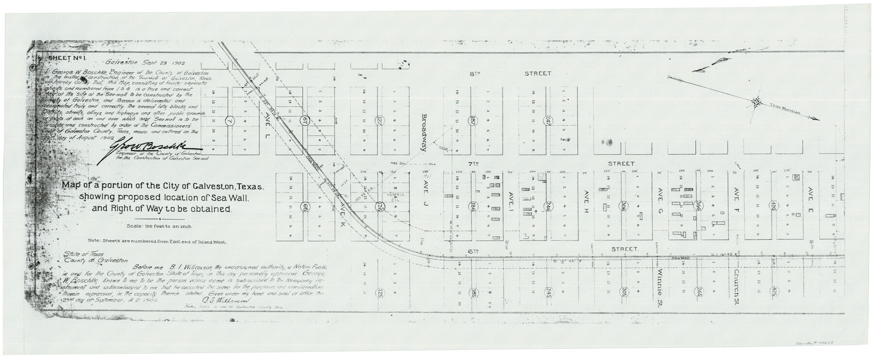
Map of a portion of the City of Galveston, Texas showing proposed location of Sea Wall and Right of Way to be obtained
Galveston Miscellaneous 2
-
Map/Doc
73625
-
Collection
General Map Collection
-
Object Dates
1902/9/23 (Creation Date)
-
People and Organizations
Boschk (Surveyor/Engineer)
-
Counties
Galveston
-
Subjects
Cadastral City
-
Height x Width
16.5 x 38.5 inches
41.9 x 97.8 cm
-
Comments
Xerox copy
Part of: General Map Collection
Goliad County Sketch File 10
![24226, Goliad County Sketch File 10, General Map Collection](https://historictexasmaps.com/wmedia_w700/pdf_converted_jpg/qi_pdf_thumbnail_11405.jpg)
Print $4.00
- Digital $50.00
Goliad County Sketch File 10
1859
Size 9.3 x 8.1 inches
Map/Doc 24226
Harris County Sketch File 81
![11669, Harris County Sketch File 81, General Map Collection](https://historictexasmaps.com/wmedia_w700/pdf_converted_jpg/qi_pdf_thumbnail_8100.jpg)
Print $20.00
- Digital $50.00
Harris County Sketch File 81
Size 25.5 x 16.5 inches
Map/Doc 11669
Tom Green County Sketch File 15
![38172, Tom Green County Sketch File 15, General Map Collection](https://historictexasmaps.com/wmedia_w700/pdf_converted_jpg/qi_pdf_thumbnail_14531.jpg)
Print $6.00
- Digital $50.00
Tom Green County Sketch File 15
1880
Size 13.3 x 10.9 inches
Map/Doc 38172
Flight Mission No. CRC-4R, Frame 163, Chambers County
![84922, Flight Mission No. CRC-4R, Frame 163, Chambers County, General Map Collection](https://historictexasmaps.com/wmedia_w700/pdf_converted_jpg/qi_pdf_thumbnail_32135.jpg)
Print $20.00
- Digital $50.00
Flight Mission No. CRC-4R, Frame 163, Chambers County
1956
Size 18.5 x 22.4 inches
Map/Doc 84922
Trinity River, Kimbrough Lake Sheet
![65225, Trinity River, Kimbrough Lake Sheet, General Map Collection](https://historictexasmaps.com/wmedia_w700/maps/65225.tif.jpg)
Print $4.00
- Digital $50.00
Trinity River, Kimbrough Lake Sheet
1929
Size 26.0 x 19.4 inches
Map/Doc 65225
Coke County Sketch File 27
![18638, Coke County Sketch File 27, General Map Collection](https://historictexasmaps.com/wmedia_w700/pdf_converted_jpg/qi_pdf_thumbnail_10179.jpg)
Print $26.00
- Digital $50.00
Coke County Sketch File 27
1937
Size 11.2 x 8.7 inches
Map/Doc 18638
[Folder for] Nautical Chart 11305: Texas Intracoastal Waterway, Laguna Madre, Rincon de San Jose to Chubby Island
![75913, [Folder for] Nautical Chart 11305: Texas Intracoastal Waterway, Laguna Madre, Rincon de San Jose to Chubby Island, General Map Collection](https://historictexasmaps.com/wmedia_w700/maps/75913.tif.jpg)
Print $20.00
- Digital $50.00
[Folder for] Nautical Chart 11305: Texas Intracoastal Waterway, Laguna Madre, Rincon de San Jose to Chubby Island
1976
Size 16.0 x 19.0 inches
Map/Doc 75913
Concho County Sketch File 8 1/2
![19134, Concho County Sketch File 8 1/2, General Map Collection](https://historictexasmaps.com/wmedia_w700/pdf_converted_jpg/qi_pdf_thumbnail_10335.jpg)
Print $8.00
- Digital $50.00
Concho County Sketch File 8 1/2
1887
Size 8.4 x 10.6 inches
Map/Doc 19134
Clay County Boundary File 3
![51364, Clay County Boundary File 3, General Map Collection](https://historictexasmaps.com/wmedia_w700/pdf_converted_jpg/qi_pdf_thumbnail_15754.jpg)
Print $4.00
- Digital $50.00
Clay County Boundary File 3
Size 11.2 x 8.6 inches
Map/Doc 51364
The City of Austin and Suburbs
![2204, The City of Austin and Suburbs, General Map Collection](https://historictexasmaps.com/wmedia_w700/maps/2204.tif.jpg)
Print $40.00
- Digital $50.00
The City of Austin and Suburbs
1919
Size 120.7 x 73.5 inches
Map/Doc 2204
Duval County Working Sketch 41
![68765, Duval County Working Sketch 41, General Map Collection](https://historictexasmaps.com/wmedia_w700/maps/68765.tif.jpg)
Print $20.00
- Digital $50.00
Duval County Working Sketch 41
Size 24.1 x 22.9 inches
Map/Doc 68765
You may also like
Colorado County Working Sketch 34
![68134, Colorado County Working Sketch 34, General Map Collection](https://historictexasmaps.com/wmedia_w700/maps/68134.tif.jpg)
Print $20.00
- Digital $50.00
Colorado County Working Sketch 34
Size 26.9 x 23.9 inches
Map/Doc 68134
O'Neall Terrace Annex, a Re-Subdivision of the South One-half of Blocks 25 and 31 and all of Blocks 30, 32, and 33 of McCrummen's Second Addition, Lubbock, Texas
![92747, O'Neall Terrace Annex, a Re-Subdivision of the South One-half of Blocks 25 and 31 and all of Blocks 30, 32, and 33 of McCrummen's Second Addition, Lubbock, Texas, Twichell Survey Records](https://historictexasmaps.com/wmedia_w700/maps/92747.tif.jpg)
Print $20.00
- Digital $50.00
O'Neall Terrace Annex, a Re-Subdivision of the South One-half of Blocks 25 and 31 and all of Blocks 30, 32, and 33 of McCrummen's Second Addition, Lubbock, Texas
1928
Size 23.2 x 27.6 inches
Map/Doc 92747
General Highway Map, Glasscock County, Texas
![79100, General Highway Map, Glasscock County, Texas, Texas State Library and Archives](https://historictexasmaps.com/wmedia_w700/maps/79100.tif.jpg)
Print $20.00
General Highway Map, Glasscock County, Texas
1940
Size 18.5 x 25.2 inches
Map/Doc 79100
Lipscomb County Rolled Sketch 8
![9453, Lipscomb County Rolled Sketch 8, General Map Collection](https://historictexasmaps.com/wmedia_w700/maps/9453.tif.jpg)
Print $40.00
- Digital $50.00
Lipscomb County Rolled Sketch 8
1940
Size 59.2 x 28.5 inches
Map/Doc 9453
Shelby County Sketch File 6
![36601, Shelby County Sketch File 6, General Map Collection](https://historictexasmaps.com/wmedia_w700/pdf_converted_jpg/qi_pdf_thumbnail_14188.jpg)
Print $8.00
- Digital $50.00
Shelby County Sketch File 6
1854
Size 12.4 x 8.2 inches
Map/Doc 36601
Lubbock County Sketch File 15
![30440, Lubbock County Sketch File 15, General Map Collection](https://historictexasmaps.com/wmedia_w700/pdf_converted_jpg/qi_pdf_thumbnail_12822.jpg)
Print $6.00
- Digital $50.00
Lubbock County Sketch File 15
1902
Size 11.2 x 8.8 inches
Map/Doc 30440
Hutchinson County Sketch File 5
![10498, Hutchinson County Sketch File 5, General Map Collection](https://historictexasmaps.com/wmedia_w700/pdf_converted_jpg/qi_pdf_thumbnail_7167.jpg)
Print $60.00
- Digital $50.00
Hutchinson County Sketch File 5
Size 15.1 x 62.7 inches
Map/Doc 10498
Fort Bend County Boundary File 2
![53559, Fort Bend County Boundary File 2, General Map Collection](https://historictexasmaps.com/wmedia_w700/pdf_converted_jpg/qi_pdf_thumbnail_16048.jpg)
Print $8.00
- Digital $50.00
Fort Bend County Boundary File 2
Size 14.3 x 8.9 inches
Map/Doc 53559
Flight Mission No. CRC-3R, Frame 9, Chambers County
![84783, Flight Mission No. CRC-3R, Frame 9, Chambers County, General Map Collection](https://historictexasmaps.com/wmedia_w700/pdf_converted_jpg/qi_pdf_thumbnail_31998.jpg)
Print $20.00
- Digital $50.00
Flight Mission No. CRC-3R, Frame 9, Chambers County
1956
Size 18.7 x 22.4 inches
Map/Doc 84783
Sectional map of Texas traversed by the Missouri, Kansas & Texas Railway, showing the crops adapted to each section, with the elevation and annual rainfall
![95818, Sectional map of Texas traversed by the Missouri, Kansas & Texas Railway, showing the crops adapted to each section, with the elevation and annual rainfall, Cobb Digital Map Collection](https://historictexasmaps.com/wmedia_w700/maps/95818.tif.jpg)
Print $20.00
- Digital $50.00
Sectional map of Texas traversed by the Missouri, Kansas & Texas Railway, showing the crops adapted to each section, with the elevation and annual rainfall
Size 21.9 x 22.8 inches
Map/Doc 95818
Schleicher County Working Sketch 11
![63813, Schleicher County Working Sketch 11, General Map Collection](https://historictexasmaps.com/wmedia_w700/maps/63813.tif.jpg)
Print $20.00
- Digital $50.00
Schleicher County Working Sketch 11
Size 18.9 x 13.8 inches
Map/Doc 63813
Val Verde County Working Sketch 82
![72217, Val Verde County Working Sketch 82, General Map Collection](https://historictexasmaps.com/wmedia_w700/maps/72217.tif.jpg)
Print $20.00
- Digital $50.00
Val Verde County Working Sketch 82
Size 42.1 x 33.1 inches
Map/Doc 72217