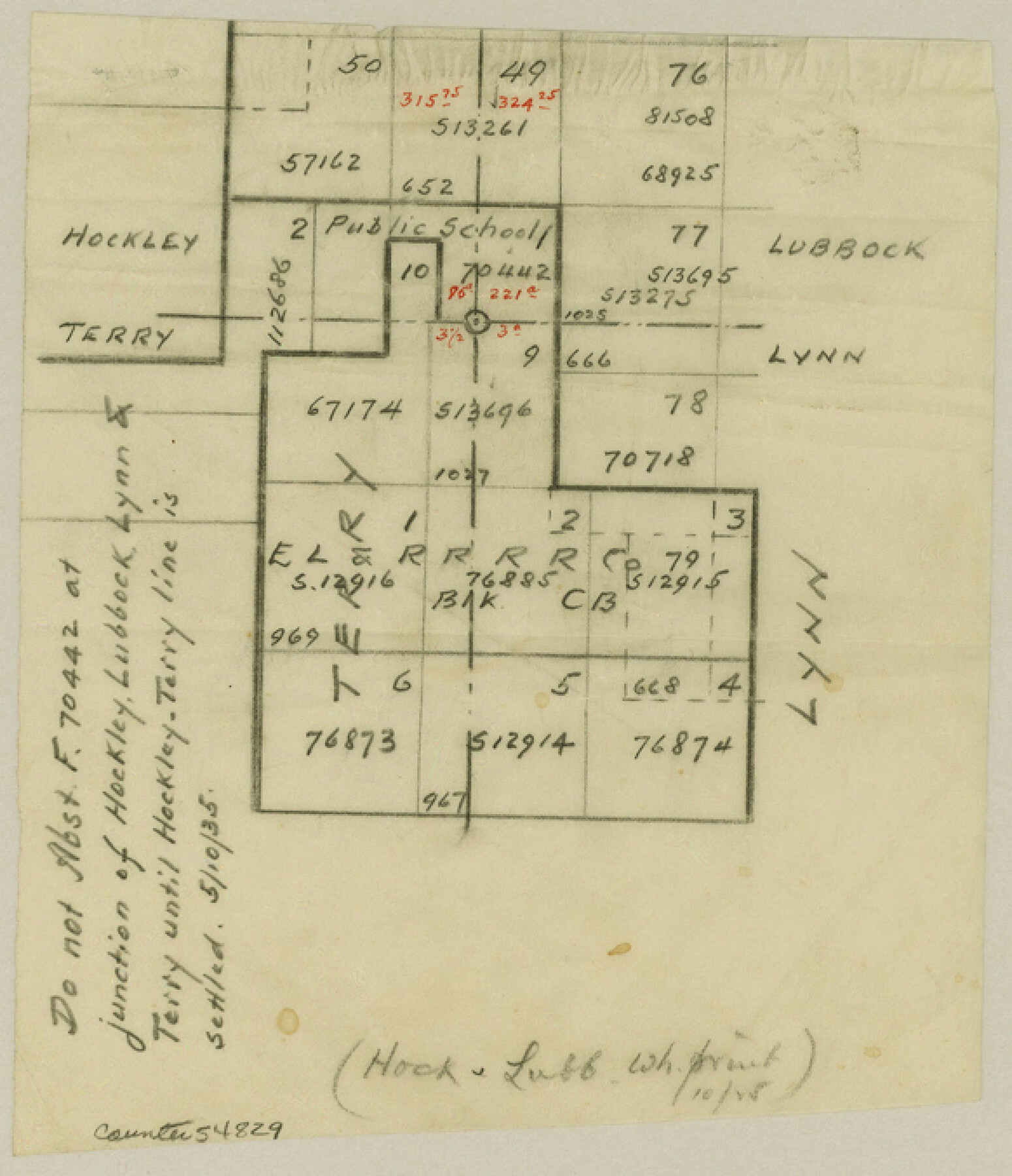
Hockley County Boundary File 5
Hockley-Lubbock
-
Map/Doc
54829
-
Collection
General Map Collection
-
Counties
Hockley
-
Subjects
County Boundaries
-
Height x Width
6.8 x 5.8 inches
17.3 x 14.7 cm
Part of: General Map Collection
Presidio County Working Sketch 58

Print $20.00
- Digital $50.00
Presidio County Working Sketch 58
1956
Size 21.9 x 24.2 inches
Map/Doc 71735
Val Verde County Working Sketch 116

Print $20.00
- Digital $50.00
Val Verde County Working Sketch 116
2003
Size 38.4 x 34.8 inches
Map/Doc 78493
Matagorda County Rolled Sketch 16

Print $20.00
- Digital $50.00
Matagorda County Rolled Sketch 16
Size 25.7 x 41.6 inches
Map/Doc 7591
Map of Silverton, County Seat of Briscoe County, Texas

Print $20.00
- Digital $50.00
Map of Silverton, County Seat of Briscoe County, Texas
1891
Size 24.3 x 19.8 inches
Map/Doc 4832
Marion County Rolled Sketch JRC

Print $20.00
- Digital $50.00
Marion County Rolled Sketch JRC
1953
Size 19.4 x 20.5 inches
Map/Doc 6662
Gregg County Rolled Sketch 9A

Print $20.00
- Digital $50.00
Gregg County Rolled Sketch 9A
1932
Size 38.1 x 30.2 inches
Map/Doc 6035
Map of Kerr County

Print $40.00
- Digital $50.00
Map of Kerr County
1895
Size 41.3 x 57.1 inches
Map/Doc 7824
Amistad International Reservoir on Rio Grande 67

Print $20.00
- Digital $50.00
Amistad International Reservoir on Rio Grande 67
1949
Size 28.3 x 39.5 inches
Map/Doc 73352
Hardin County Working Sketch 13

Print $20.00
- Digital $50.00
Hardin County Working Sketch 13
1934
Size 25.5 x 17.6 inches
Map/Doc 63411
[Portion of Harris County]
![78482, [Portion of Harris County], General Map Collection](https://historictexasmaps.com/wmedia_w700/maps/78482.tif.jpg)
Print $2.00
- Digital $50.00
[Portion of Harris County]
Size 9.8 x 7.2 inches
Map/Doc 78482
Map of the Recognised Line M. EL. P. & P. R. R. from East Line of Bexar Land District to El Paso

Print $20.00
- Digital $50.00
Map of the Recognised Line M. EL. P. & P. R. R. from East Line of Bexar Land District to El Paso
1857
Size 7.5 x 41.8 inches
Map/Doc 2218
Hall County Sketch File 3

Print $3.00
- Digital $50.00
Hall County Sketch File 3
Size 11.7 x 17.1 inches
Map/Doc 24799
You may also like
Wise County Sketch File 2

Print $8.00
- Digital $50.00
Wise County Sketch File 2
1856
Size 8.2 x 13.4 inches
Map/Doc 40523
Flight Mission No. CRE-1R, Frame 192, Jackson County

Print $20.00
- Digital $50.00
Flight Mission No. CRE-1R, Frame 192, Jackson County
1956
Size 18.5 x 22.3 inches
Map/Doc 85346
Clay County Boundary File 17a

Print $40.00
- Digital $50.00
Clay County Boundary File 17a
Size 47.0 x 22.0 inches
Map/Doc 51435
General Highway Map, Sabine County, Texas

Print $20.00
General Highway Map, Sabine County, Texas
1940
Size 24.7 x 18.3 inches
Map/Doc 79233
Bandera County Rolled Sketch 3

Print $20.00
- Digital $50.00
Bandera County Rolled Sketch 3
1947
Size 29.3 x 35.8 inches
Map/Doc 5115
Brooks County Rolled Sketch 20

Print $20.00
- Digital $50.00
Brooks County Rolled Sketch 20
1943
Size 27.0 x 26.4 inches
Map/Doc 5342
Hidalgo County Working Sketch 10

Print $40.00
- Digital $50.00
Hidalgo County Working Sketch 10
2011
Size 59.9 x 29.5 inches
Map/Doc 89998
Trace of a copy of the map captured at the battle of Resaca de la Palma

Print $20.00
- Digital $50.00
Trace of a copy of the map captured at the battle of Resaca de la Palma
Size 18.3 x 27.3 inches
Map/Doc 73054
E. N. Gustafson's survey of Northern Portion of Lake Austin, Matagorda Co., TX

Print $40.00
- Digital $50.00
E. N. Gustafson's survey of Northern Portion of Lake Austin, Matagorda Co., TX
1926
Size 43.0 x 52.5 inches
Map/Doc 2068
Aransas County Rolled Sketch 2

Print $40.00
- Digital $50.00
Aransas County Rolled Sketch 2
1950
Size 54.7 x 50.5 inches
Map/Doc 73612
Dallas County Sketch File 20

Print $4.00
- Digital $50.00
Dallas County Sketch File 20
Size 12.2 x 7.8 inches
Map/Doc 20441
![94197, New Mexico [Verso], General Map Collection](https://historictexasmaps.com/wmedia_w700/maps/94197.tif.jpg)