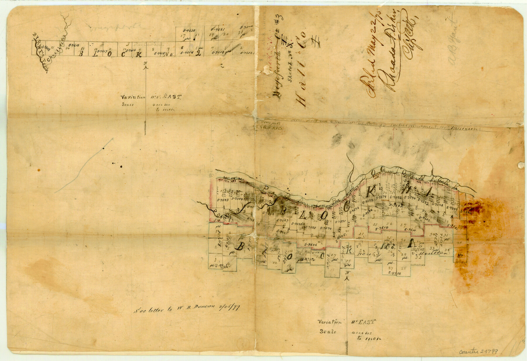
Hall County Sketch File 3
[Sketch of Block 1, south of river]
-
Map/Doc
24799
-
Collection
General Map Collection
-
Object Dates
1875/5/22 (File Date)
-
People and Organizations
Rhoads Fisher (GLO Clerk)
-
Counties
Hall
-
Subjects
Surveying Sketch File
-
Height x Width
11.7 x 17.1 inches
29.7 x 43.4 cm
-
Medium
paper, manuscript
-
Scale
1:4000
-
Features
Byrne's Fork [of Charlie's Creek]
Charlie's Creek
Prairie Dog Town Fork
Powell Creek
Part of: General Map Collection
Kleberg County Aerial Photograph Index Sheet 1

Print $20.00
- Digital $50.00
Kleberg County Aerial Photograph Index Sheet 1
1956
Size 19.6 x 23.6 inches
Map/Doc 83718
Garza County Sketch File 26

Print $4.00
- Digital $50.00
Garza County Sketch File 26
Size 10.9 x 8.5 inches
Map/Doc 24095
Flight Mission No. BRA-16M, Frame 144, Jefferson County

Print $20.00
- Digital $50.00
Flight Mission No. BRA-16M, Frame 144, Jefferson County
1953
Size 18.6 x 22.5 inches
Map/Doc 85750

![94160, Austin and Vicinity [Recto], General Map Collection](https://historictexasmaps.com/wmedia_w700/maps/94160.tif.jpg)
Castro County Sketch File 4j

Print $4.00
- Digital $50.00
Castro County Sketch File 4j
Size 13.5 x 8.7 inches
Map/Doc 17483
Coke County Working Sketch 7

Print $20.00
- Digital $50.00
Coke County Working Sketch 7
1924
Size 15.8 x 20.4 inches
Map/Doc 68044

Carta General de la República Mexicana Formada en vista de los datos mas recientes y exactos que se han reunido con tal objeto, y constan en la noticia presentada al Exmo. Sr. Ministro de Fomento, por Antonio García y Cubas

Print $20.00
- Digital $50.00
Carta General de la República Mexicana Formada en vista de los datos mas recientes y exactos que se han reunido con tal objeto, y constan en la noticia presentada al Exmo. Sr. Ministro de Fomento, por Antonio García y Cubas
Size 23.3 x 29.2 inches
Map/Doc 95824
Kinney County Sketch File 38

Print $8.00
- Digital $50.00
Kinney County Sketch File 38
1882
Size 14.3 x 8.7 inches
Map/Doc 29188
Runnels County Sketch File 19 and 22

Print $48.00
Runnels County Sketch File 19 and 22
1887
Size 14.0 x 21.2 inches
Map/Doc 12254
[St. Louis & Southwestern]
![64281, [St. Louis & Southwestern], General Map Collection](https://historictexasmaps.com/wmedia_w700/maps/64281.tif.jpg)
Print $20.00
- Digital $50.00
[St. Louis & Southwestern]
Size 20.9 x 29.0 inches
Map/Doc 64281
You may also like
A Splendid Endorsement of the Red River Valley Lands in the Famous Red River Valley of North Texas

Print $20.00
- Digital $50.00
A Splendid Endorsement of the Red River Valley Lands in the Famous Red River Valley of North Texas
1901
Size 10.2 x 12.7 inches
Map/Doc 96601
Map of the Pitchfork Ranch

Print $20.00
- Digital $50.00
Map of the Pitchfork Ranch
1915
Size 40.2 x 36.5 inches
Map/Doc 4490
Burnet County Working Sketch 19

Print $20.00
- Digital $50.00
Burnet County Working Sketch 19
1982
Size 38.2 x 36.7 inches
Map/Doc 67862
Burnet County Sketch File 30

Print $4.00
- Digital $50.00
Burnet County Sketch File 30
Size 11.0 x 8.0 inches
Map/Doc 16746
Shelby County Rolled Sketch 17

Print $20.00
- Digital $50.00
Shelby County Rolled Sketch 17
1975
Size 34.6 x 26.4 inches
Map/Doc 7783
Brewster County Sketch File N-19

Print $40.00
- Digital $50.00
Brewster County Sketch File N-19
1946
Size 18.7 x 26.2 inches
Map/Doc 10966
Lampasas County Boundary File 4a

Print $12.00
- Digital $50.00
Lampasas County Boundary File 4a
Size 12.8 x 8.2 inches
Map/Doc 56122

DeWitt County Sketch File 1

Print $11.00
- Digital $50.00
DeWitt County Sketch File 1
1851
Size 8.4 x 8.2 inches
Map/Doc 20794
[Surveys in Austin County]
![35, [Surveys in Austin County], General Map Collection](https://historictexasmaps.com/wmedia_w700/maps/35.tif.jpg)
Print $20.00
- Digital $50.00
[Surveys in Austin County]
1840
Size 20.8 x 28.2 inches
Map/Doc 35
Nacogdoches County Sketch File 20

Print $26.00
- Digital $50.00
Nacogdoches County Sketch File 20
Size 12.6 x 7.9 inches
Map/Doc 32275
[County School Lands]
![91089, [County School Lands], Twichell Survey Records](https://historictexasmaps.com/wmedia_w700/maps/91089-1.tif.jpg)
Print $20.00
- Digital $50.00
[County School Lands]
Size 14.3 x 14.2 inches
Map/Doc 91089