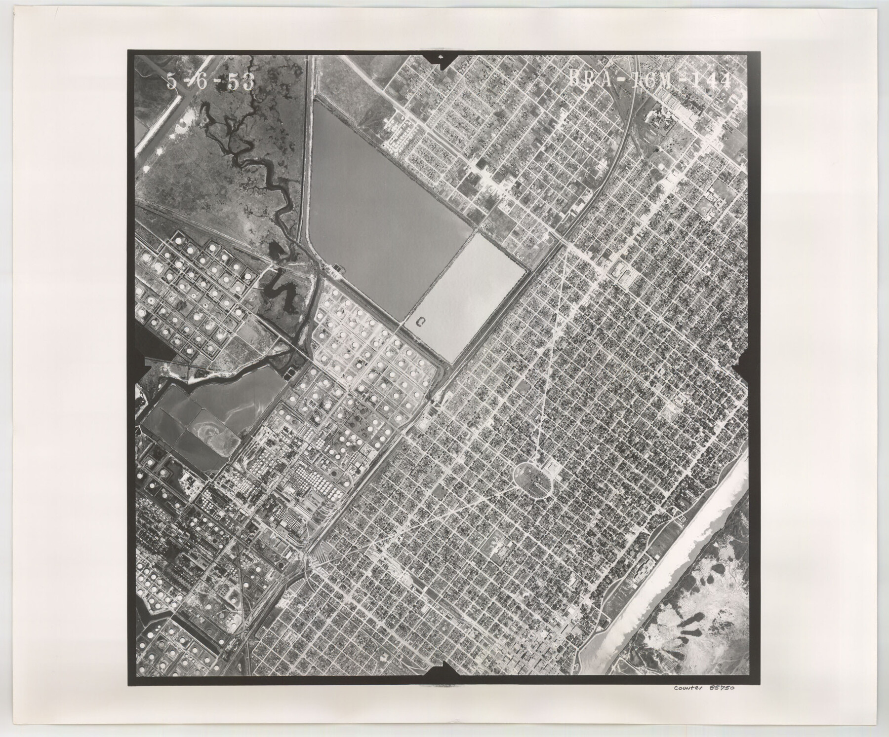
Flight Mission No. BRA-16M, Frame 144, Jefferson County
BRA-16M-144
-
Map/Doc
85750
-
Collection
General Map Collection
-
Object Dates
1953/5/6 (Creation Date)
-
People and Organizations
U. S. Department of Agriculture (Publisher)
-
Counties
Jefferson
-
Subjects
Aerial Photograph
-
Height x Width
18.6 x 22.5 inches
47.2 x 57.2 cm
-
Comments
Flown by Jack Ammann Photogrammetric Engineers of San Antonio, Texas.
Part of: General Map Collection
Marion County Working Sketch 37

Print $20.00
- Digital $50.00
Marion County Working Sketch 37
1986
Size 30.0 x 43.0 inches
Map/Doc 70813
Brewster County Rolled Sketch 114

Print $20.00
- Digital $50.00
Brewster County Rolled Sketch 114
1964
Size 17.3 x 11.4 inches
Map/Doc 5292
Jeff Davis County Sketch File 3

Print $22.00
- Digital $50.00
Jeff Davis County Sketch File 3
Size 12.3 x 8.6 inches
Map/Doc 27892
Williamson County Working Sketch 9

Print $20.00
- Digital $50.00
Williamson County Working Sketch 9
1954
Size 31.2 x 30.0 inches
Map/Doc 72569
Orange County Rolled Sketch 27

Print $20.00
- Digital $50.00
Orange County Rolled Sketch 27
1954
Size 22.3 x 34.5 inches
Map/Doc 7186
Motley County Boundary File 2d

Print $22.00
- Digital $50.00
Motley County Boundary File 2d
Size 14.3 x 8.7 inches
Map/Doc 57550
Map from Corpus Christi to Matagorda Bays, Texas [Inset: Survey of the channel of Copono Bay]
![72976, Map from Corpus Christi to Matagorda Bays, Texas [Inset: Survey of the channel of Copono Bay], General Map Collection](https://historictexasmaps.com/wmedia_w700/maps/72976.tif.jpg)
Print $20.00
- Digital $50.00
Map from Corpus Christi to Matagorda Bays, Texas [Inset: Survey of the channel of Copono Bay]
1846
Size 18.1 x 27.5 inches
Map/Doc 72976
Pecos County Sketch File 23

Print $20.00
- Digital $50.00
Pecos County Sketch File 23
1886
Size 18.0 x 18.0 inches
Map/Doc 12162

Tarrant County Working Sketch 5

Print $20.00
- Digital $50.00
Tarrant County Working Sketch 5
1980
Size 27.7 x 27.3 inches
Map/Doc 62422
Map of Bastrop County, Texas

Print $20.00
- Digital $50.00
Map of Bastrop County, Texas
1879
Size 24.6 x 24.1 inches
Map/Doc 4507
Galveston Harbor and Channel, Texas Rehabilitation of South Jetty, Comparison of Shorelines and Offshore Contours 1890 to 1960

Print $20.00
- Digital $50.00
Galveston Harbor and Channel, Texas Rehabilitation of South Jetty, Comparison of Shorelines and Offshore Contours 1890 to 1960
1961
Size 31.6 x 41.8 inches
Map/Doc 61827
You may also like
Galveston County Working Sketch 4

Print $20.00
- Digital $50.00
Galveston County Working Sketch 4
1930
Size 19.7 x 17.2 inches
Map/Doc 69341
Presidio County Sketch File 84

Print $20.00
- Digital $50.00
Presidio County Sketch File 84
1949
Size 15.2 x 37.2 inches
Map/Doc 11723
Brazoria County Aerial Photograph Index Sheet 7

Print $20.00
- Digital $50.00
Brazoria County Aerial Photograph Index Sheet 7
1953
Size 23.9 x 19.8 inches
Map/Doc 83669
County Map of the Pan-Handle of Texas, and the line of the Denver, Texas and Ft. Worth R'y

Print $20.00
County Map of the Pan-Handle of Texas, and the line of the Denver, Texas and Ft. Worth R'y
1888
Size 7.5 x 10.9 inches
Map/Doc 76296

Houston County Working Sketch 12

Print $20.00
- Digital $50.00
Houston County Working Sketch 12
1956
Size 24.0 x 27.3 inches
Map/Doc 66242
Bandera County Working Sketch 4

Print $20.00
- Digital $50.00
Bandera County Working Sketch 4
1914
Size 18.6 x 19.3 inches
Map/Doc 67597
Map of San Patricio County

Print $40.00
- Digital $50.00
Map of San Patricio County
1896
Size 31.6 x 51.2 inches
Map/Doc 63018
Starr County Sketch File 11

Print $28.00
- Digital $50.00
Starr County Sketch File 11
1885
Size 12.8 x 8.1 inches
Map/Doc 36865
Castro County Sketch File 4c

Print $4.00
- Digital $50.00
Castro County Sketch File 4c
Size 12.7 x 8.8 inches
Map/Doc 17469
Motley County Sketch File E (S)

Print $52.00
- Digital $50.00
Motley County Sketch File E (S)
Size 14.6 x 9.0 inches
Map/Doc 32169
Greer County Sketch File 8

Print $20.00
- Digital $50.00
Greer County Sketch File 8
Size 16.7 x 23.6 inches
Map/Doc 11584