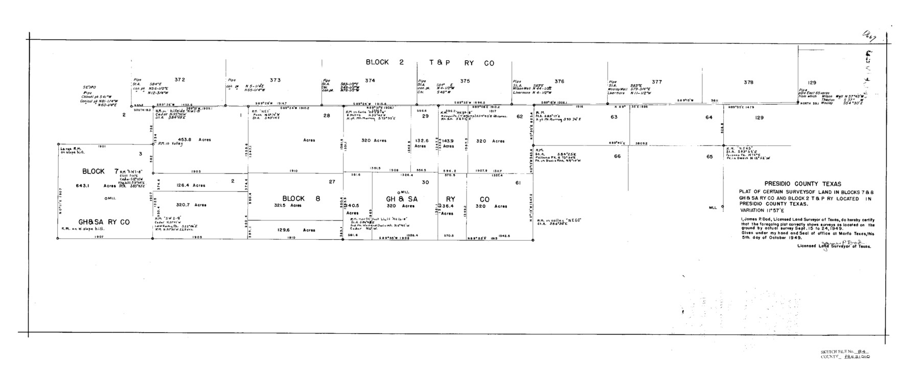
Presidio County Sketch File 84
Plat of Certain Surveys of Land in Blocks 7 & 8, GH&SARRCo. & Block 2, T&PRRCo. Located in Presidio County, Texas
-
Map/Doc
11723
-
Collection
General Map Collection
-
Object Dates
9/24/1949 (Survey Date)
11/1/1949 (File Date)
10/5/1949 (Creation Date)
-
People and Organizations
James P. Dod (Surveyor/Engineer)
H.F. McDonald (Draftsman)
H.F. McDonald (Compiler)
-
Counties
Presidio
-
Subjects
Surveying Sketch File
-
Height x Width
15.2 x 37.2 inches
38.6 x 94.5 cm
-
Medium
paper, print
-
Comments
See Presidio County Sketch File 83 (34722) for report.
-
Features
Chinati Peak
Mount Murray
Paisano Peak
Davis Mountains
Wooley Well
Wilson Well
Thaxton Well
Related maps
Presidio County Sketch File 83

Print $8.00
- Digital $50.00
Presidio County Sketch File 83
1949
Size 11.3 x 8.8 inches
Map/Doc 34722
Part of: General Map Collection
Presidio County Sketch File 60a

Print $4.00
- Digital $50.00
Presidio County Sketch File 60a
1936
Size 8.7 x 15.5 inches
Map/Doc 34643
Briscoe County Rolled Sketch 20

Print $20.00
- Digital $50.00
Briscoe County Rolled Sketch 20
1949
Size 37.4 x 21.7 inches
Map/Doc 5334
Armstrong County Sketch File 8

Print $8.00
- Digital $50.00
Armstrong County Sketch File 8
Size 14.2 x 8.8 inches
Map/Doc 13705
Right of Way and Track Map, The Missouri, Kansas and Texas Ry. of Texas operated by the Missouri, Kansas and Texas Ry. of Texas, Henrietta Division

Print $40.00
- Digital $50.00
Right of Way and Track Map, The Missouri, Kansas and Texas Ry. of Texas operated by the Missouri, Kansas and Texas Ry. of Texas, Henrietta Division
1918
Size 25.2 x 56.6 inches
Map/Doc 64067
Flight Mission No. CGI-3N, Frame 139, Cameron County

Print $20.00
- Digital $50.00
Flight Mission No. CGI-3N, Frame 139, Cameron County
1954
Size 18.7 x 22.3 inches
Map/Doc 84612
Tarrant County State Real Property Sketch 1

Print $60.00
- Digital $50.00
Tarrant County State Real Property Sketch 1
2007
Size 24.5 x 35.3 inches
Map/Doc 88666
Wood County Working Sketch 13

Print $20.00
- Digital $50.00
Wood County Working Sketch 13
1973
Size 23.1 x 20.2 inches
Map/Doc 62013
Armstrong County Sketch File A-10

Print $40.00
- Digital $50.00
Armstrong County Sketch File A-10
Size 22.6 x 35.6 inches
Map/Doc 10852
Franklin County Sketch File 5

Print $2.00
- Digital $50.00
Franklin County Sketch File 5
Size 8.2 x 10.7 inches
Map/Doc 23017
Montgomery County Sketch File 26

Print $6.00
- Digital $50.00
Montgomery County Sketch File 26
1845
Size 13.4 x 11.4 inches
Map/Doc 31871
Howard County Working Sketch 10

Print $20.00
- Digital $50.00
Howard County Working Sketch 10
1962
Size 24.4 x 26.1 inches
Map/Doc 66278
Culberson County Sketch File WJ1

Print $6.00
- Digital $50.00
Culberson County Sketch File WJ1
1927
Size 11.2 x 8.9 inches
Map/Doc 20154
You may also like
Engineer map showing engineer information at 23 O'Clock 23 Oct. 1918 drawn under direction of Col. W.A. Mitchell

Print $20.00
Engineer map showing engineer information at 23 O'Clock 23 Oct. 1918 drawn under direction of Col. W.A. Mitchell
1918
Size 19.6 x 12.5 inches
Map/Doc 94127
Bird's Eye View of La Grange, Fayette County, Texas

Print $20.00
Bird's Eye View of La Grange, Fayette County, Texas
1880
Size 24.1 x 31.2 inches
Map/Doc 89096
General Highway Map. Detail of Cities and Towns in Harris County, Texas

Print $20.00
General Highway Map. Detail of Cities and Towns in Harris County, Texas
1939
Size 18.4 x 24.9 inches
Map/Doc 79117
Bird's Eye View of the City of Brenham, Washington County, Texas

Print $20.00
Bird's Eye View of the City of Brenham, Washington County, Texas
1881
Size 19.4 x 26.7 inches
Map/Doc 89076
Fisher County Working Sketch 7

Print $20.00
- Digital $50.00
Fisher County Working Sketch 7
1944
Size 36.7 x 28.9 inches
Map/Doc 69141
Hall County Sketch File 35

Print $22.00
- Digital $50.00
Hall County Sketch File 35
1913
Size 11.2 x 8.8 inches
Map/Doc 24884
Matagorda County NRC Article 33.136 Sketch 21

Print $42.00
Matagorda County NRC Article 33.136 Sketch 21
2025
Map/Doc 97429
Rusk County Sketch File 46

Print $4.00
Rusk County Sketch File 46
1846
Size 12.6 x 7.8 inches
Map/Doc 35595
Brewster County Rolled Sketch 95

Print $20.00
- Digital $50.00
Brewster County Rolled Sketch 95
1947
Size 29.4 x 38.0 inches
Map/Doc 5252
[Pencil sketch of Wm. Rivers survey]
![91968, [Pencil sketch of Wm. Rivers survey], Twichell Survey Records](https://historictexasmaps.com/wmedia_w700/maps/91968-1.tif.jpg)
Print $3.00
- Digital $50.00
[Pencil sketch of Wm. Rivers survey]
Size 10.1 x 16.5 inches
Map/Doc 91968
Parker County Boundary File 68

Print $12.00
- Digital $50.00
Parker County Boundary File 68
Size 8.1 x 3.6 inches
Map/Doc 57848
Foard County Sketch File 13

Print $6.00
- Digital $50.00
Foard County Sketch File 13
1885
Size 13.0 x 8.5 inches
Map/Doc 22816