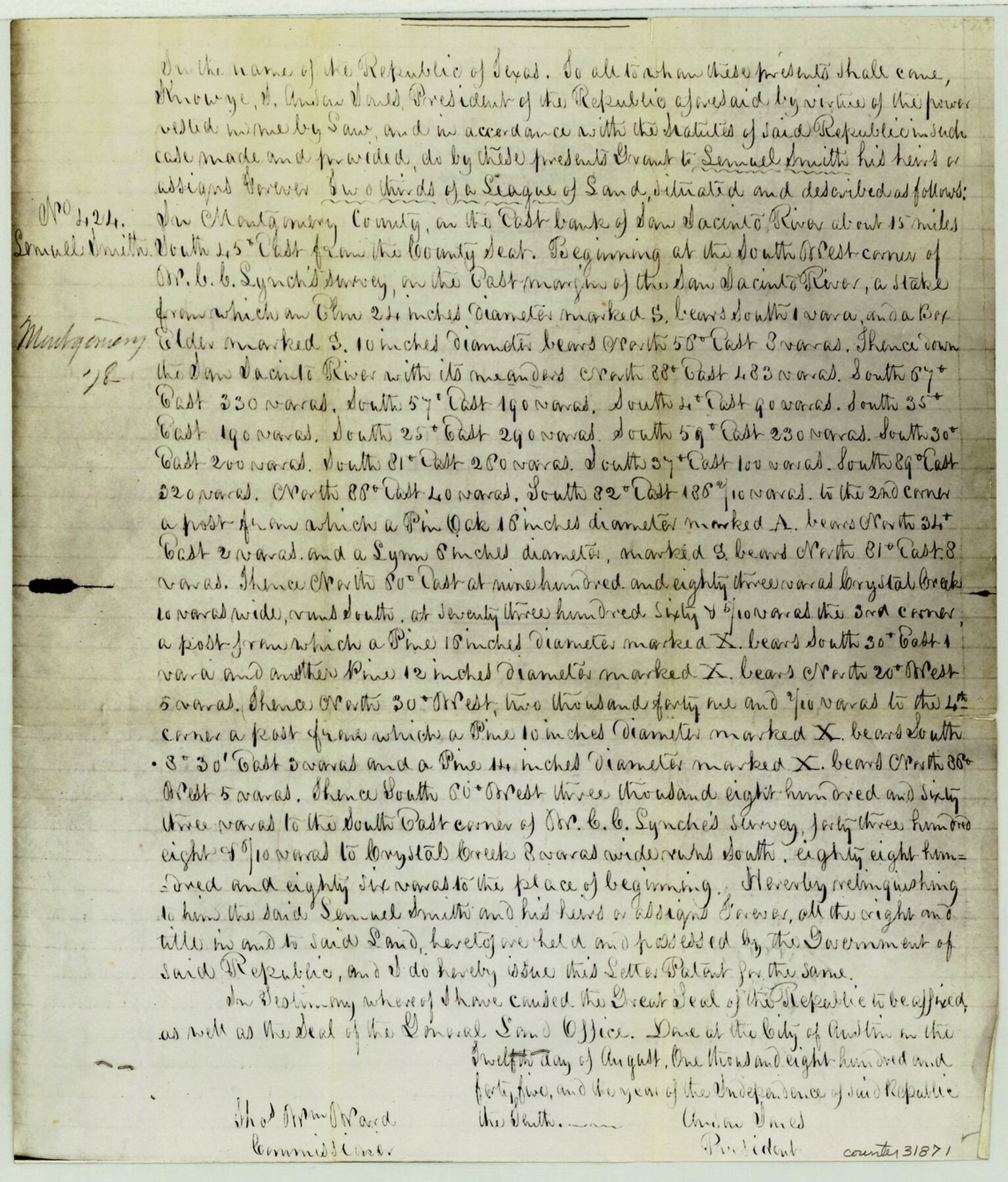
Montgomery County Sketch File 26
[Copy of the patent of the Lemuel Smith 2/3 League]
-
Map/Doc
31871
-
Collection
General Map Collection
-
Object Dates
8/12/1845 (Creation Date)
-
People and Organizations
Anson Jones (President)
Thomas William Ward (GLO Commissioner)
-
Counties
Montgomery
-
Subjects
Surveying Sketch File
-
Height x Width
13.4 x 11.4 inches
34.0 x 29.0 cm
-
Medium
photostat
-
Features
San Jacinto River
Crystal Creek
Part of: General Map Collection
Flight Mission No. CUG-2P, Frame 76, Kleberg County

Print $20.00
- Digital $50.00
Flight Mission No. CUG-2P, Frame 76, Kleberg County
1956
Size 18.4 x 22.1 inches
Map/Doc 86208
Motley County Sketch File 36 (S)

Print $4.00
- Digital $50.00
Motley County Sketch File 36 (S)
1893
Size 11.0 x 8.8 inches
Map/Doc 32220
Map of Duval County

Print $40.00
- Digital $50.00
Map of Duval County
1890
Size 69.8 x 43.8 inches
Map/Doc 4936
Flight Mission No. DIX-6P, Frame 127, Aransas County

Print $20.00
- Digital $50.00
Flight Mission No. DIX-6P, Frame 127, Aransas County
1956
Size 19.1 x 23.0 inches
Map/Doc 83833
Kleberg County Boundary File 4

Print $22.00
- Digital $50.00
Kleberg County Boundary File 4
Size 14.2 x 8.6 inches
Map/Doc 64986
Burnet County Sketch File 18

Print $4.00
- Digital $50.00
Burnet County Sketch File 18
1873
Size 8.3 x 6.5 inches
Map/Doc 16708

Chambers County Working Sketch 29

Print $20.00
- Digital $50.00
Chambers County Working Sketch 29
2009
Size 25.2 x 18.6 inches
Map/Doc 89232
Morris County Rolled Sketch 2A

Print $20.00
- Digital $50.00
Morris County Rolled Sketch 2A
Size 22.6 x 17.7 inches
Map/Doc 10285
Reeves County Sketch File 15

Print $28.00
- Digital $50.00
Reeves County Sketch File 15
1879
Size 13.1 x 8.2 inches
Map/Doc 35194
Anderson County Working Sketch 3

Print $20.00
- Digital $50.00
Anderson County Working Sketch 3
Size 15.4 x 14.1 inches
Map/Doc 67002
Harris County Working Sketch 117

Print $20.00
- Digital $50.00
Harris County Working Sketch 117
1984
Size 28.2 x 25.5 inches
Map/Doc 66009
You may also like
Anderson County Working Sketch 11a

Print $40.00
- Digital $50.00
Anderson County Working Sketch 11a
1933
Size 42.7 x 64.2 inches
Map/Doc 67011
Leon County Working Sketch 21

Print $20.00
- Digital $50.00
Leon County Working Sketch 21
1964
Size 20.9 x 22.9 inches
Map/Doc 70420
Maps of Gulf Intracoastal Waterway, Texas - Sabine River to the Rio Grande and connecting waterways including ship channels

Print $20.00
- Digital $50.00
Maps of Gulf Intracoastal Waterway, Texas - Sabine River to the Rio Grande and connecting waterways including ship channels
1966
Size 14.5 x 22.3 inches
Map/Doc 61977
Index sheet to accompany map of survey for connecting the inland waters along margin of the Gulf of Mexico from Donaldsonville in Louisiana to the Rio Grande River in Texas

Print $20.00
- Digital $50.00
Index sheet to accompany map of survey for connecting the inland waters along margin of the Gulf of Mexico from Donaldsonville in Louisiana to the Rio Grande River in Texas
Size 18.3 x 27.6 inches
Map/Doc 72689
King County Sketch File 12

Print $10.00
- Digital $50.00
King County Sketch File 12
1903
Size 11.3 x 8.6 inches
Map/Doc 29105
General Highway Map. Detail of Cities and Towns in Cherokee County, Texas [Jacksonville, Rusk, Alto, Wells, and vicinities of these cities]
![79407, General Highway Map. Detail of Cities and Towns in Cherokee County, Texas [Jacksonville, Rusk, Alto, Wells, and vicinities of these cities], Texas State Library and Archives](https://historictexasmaps.com/wmedia_w700/maps/79407.tif.jpg)
Print $20.00
General Highway Map. Detail of Cities and Towns in Cherokee County, Texas [Jacksonville, Rusk, Alto, Wells, and vicinities of these cities]
1961
Size 18.2 x 24.9 inches
Map/Doc 79407
[Sketch for Mineral Application 16700 - Pecos River Bed]
![2810, [Sketch for Mineral Application 16700 - Pecos River Bed], General Map Collection](https://historictexasmaps.com/wmedia_w700/maps/2810.tif.jpg)
Print $20.00
- Digital $50.00
[Sketch for Mineral Application 16700 - Pecos River Bed]
1927
Size 17.0 x 36.1 inches
Map/Doc 2810
Flight Mission No. CRC-6R, Frame 12, Chambers County

Print $20.00
- Digital $50.00
Flight Mission No. CRC-6R, Frame 12, Chambers County
1956
Size 18.7 x 22.3 inches
Map/Doc 84966
City of Austin and Vicinity

Print $20.00
- Digital $50.00
City of Austin and Vicinity
1839
Size 20.4 x 19.6 inches
Map/Doc 3149
Hutchinson County Rolled Sketch 42

Print $40.00
- Digital $50.00
Hutchinson County Rolled Sketch 42
1993
Size 38.5 x 49.9 inches
Map/Doc 6309
Flight Mission No. DCL-7C, Frame 60, Kenedy County

Print $20.00
- Digital $50.00
Flight Mission No. DCL-7C, Frame 60, Kenedy County
1943
Size 15.3 x 15.3 inches
Map/Doc 86048
Kinney County Sketch File 38

Print $8.00
- Digital $50.00
Kinney County Sketch File 38
1882
Size 14.3 x 8.7 inches
Map/Doc 29188