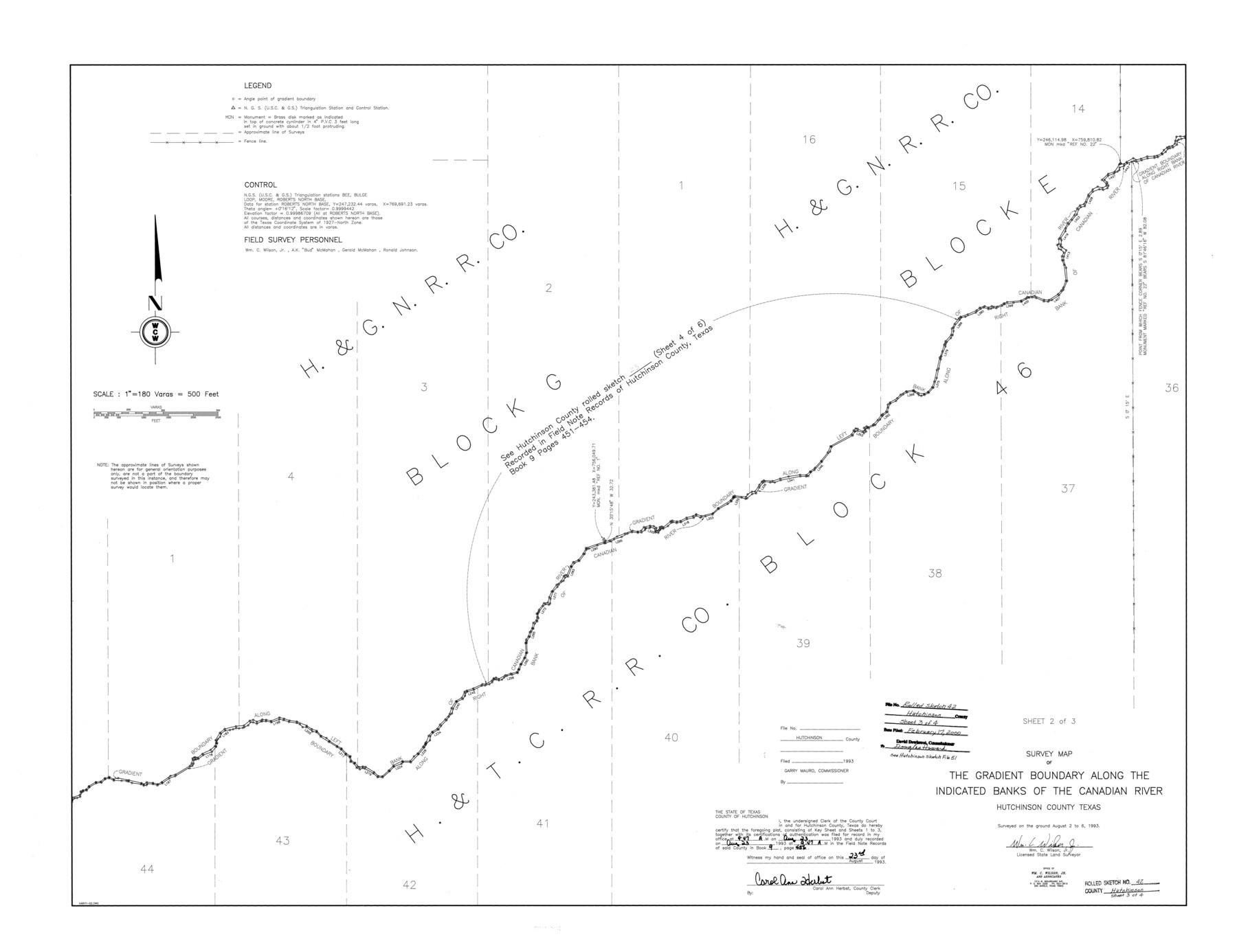
Hutchinson County Rolled Sketch 42
Survey map of the Gradient Boundary along the indicated banks of the Canadian River [Sheet 2 of 3]
-
Map/Doc
6309
-
Collection
General Map Collection
-
Object Dates
1993/8/6 (Creation Date)
2000/2/17 (File Date)
-
People and Organizations
Wm. C. Wilson, Jr. (Surveyor/Engineer)
-
Counties
Hutchinson
-
Subjects
Surveying Rolled Sketch
-
Height x Width
38.5 x 49.9 inches
97.8 x 126.7 cm
-
Medium
mylar, print
-
Scale
1" = 180 varas
-
Comments
Sheet 2 of 3. See Hutchinson County Sketch File 51 (27440) for field notes.
Related maps
Hutchinson County Sketch File 51

Print $18.00
- Digital $50.00
Hutchinson County Sketch File 51
1993
Size 14.2 x 8.6 inches
Map/Doc 27440
Part of: General Map Collection
Andrews County Rolled Sketch 14A

Print $20.00
- Digital $50.00
Andrews County Rolled Sketch 14A
1934
Size 31.2 x 23.6 inches
Map/Doc 77165
Tarrant County

Print $40.00
- Digital $50.00
Tarrant County
1942
Size 48.6 x 37.8 inches
Map/Doc 73298
San Jacinto County Rolled Sketch 15

Print $20.00
- Digital $50.00
San Jacinto County Rolled Sketch 15
2001
Size 19.2 x 25.2 inches
Map/Doc 7571
Hardin County Sketch File 46

Print $8.00
- Digital $50.00
Hardin County Sketch File 46
1875
Size 12.8 x 8.4 inches
Map/Doc 25196
Township 12 North Range 16 West, North Western District, Louisiana

Print $20.00
- Digital $50.00
Township 12 North Range 16 West, North Western District, Louisiana
1837
Size 19.7 x 24.8 inches
Map/Doc 65868
Travis County Sketch File XYZ

Print $4.00
- Digital $50.00
Travis County Sketch File XYZ
Size 10.1 x 8.3 inches
Map/Doc 38352
Jack County Working Sketch 12

Print $20.00
- Digital $50.00
Jack County Working Sketch 12
1959
Size 18.0 x 22.4 inches
Map/Doc 66438

San Patricio County Rolled Sketch 49

Print $20.00
- Digital $50.00
San Patricio County Rolled Sketch 49
1979
Size 21.2 x 20.3 inches
Map/Doc 7735
Kimble County Sketch File 5

Print $4.00
- Digital $50.00
Kimble County Sketch File 5
1858
Size 7.9 x 5.5 inches
Map/Doc 28916
Flight Mission No. CRC-3R, Frame 45, Chambers County

Print $20.00
- Digital $50.00
Flight Mission No. CRC-3R, Frame 45, Chambers County
1956
Size 18.6 x 22.5 inches
Map/Doc 84818
Blanco County Working Sketch 36

Print $20.00
- Digital $50.00
Blanco County Working Sketch 36
1979
Size 23.8 x 22.0 inches
Map/Doc 67396
You may also like
Galveston County NRC Article 33.136 Sketch 83

Print $52.00
- Digital $50.00
Galveston County NRC Article 33.136 Sketch 83
2016
Size 22.5 x 34.0 inches
Map/Doc 94968
Map of the Capitol Land Reservation

Print $40.00
- Digital $50.00
Map of the Capitol Land Reservation
Size 26.3 x 49.5 inches
Map/Doc 92042
Matagorda County Sketch File 40

Print $20.00
- Digital $50.00
Matagorda County Sketch File 40
Size 33.0 x 25.5 inches
Map/Doc 12048
Brooks County Working Sketch 14

Print $20.00
- Digital $50.00
Brooks County Working Sketch 14
1944
Size 29.2 x 20.0 inches
Map/Doc 67798
[Texas & Pacific RR. Co. Blocks 6 and 4, L. C. Denison, Guadalupe College and vicinity]
![92133, [Texas & Pacific RR. Co. Blocks 6 and 4, L. C. Denison, Guadalupe College and vicinity], Twichell Survey Records](https://historictexasmaps.com/wmedia_w700/maps/92133-1.tif.jpg)
Print $20.00
- Digital $50.00
[Texas & Pacific RR. Co. Blocks 6 and 4, L. C. Denison, Guadalupe College and vicinity]
Size 32.5 x 19.8 inches
Map/Doc 92133
The Republic County of Harrison. January 16, 1843

Print $20.00
The Republic County of Harrison. January 16, 1843
2020
Size 18.6 x 21.7 inches
Map/Doc 96174
General Highway Map, Crockett County, Texas

Print $20.00
General Highway Map, Crockett County, Texas
1940
Size 18.3 x 25.1 inches
Map/Doc 79062
From Citizens of Fannin County for the Creation of a New County to be Called Sherman, December 1, 1845

Print $20.00
From Citizens of Fannin County for the Creation of a New County to be Called Sherman, December 1, 1845
2020
Size 16.7 x 21.7 inches
Map/Doc 96397
[John W. Carpenter and Surrounding Surveys]
![91085, [John W. Carpenter and Surrounding Surveys], Twichell Survey Records](https://historictexasmaps.com/wmedia_w700/maps/91085-1.tif.jpg)
Print $20.00
- Digital $50.00
[John W. Carpenter and Surrounding Surveys]
1922
Size 17.7 x 29.6 inches
Map/Doc 91085
Sketch of surveys in Shelby Co.

Print $2.00
- Digital $50.00
Sketch of surveys in Shelby Co.
1845
Size 6.4 x 8.8 inches
Map/Doc 69741
Hudspeth County Working Sketch 40

Print $20.00
- Digital $50.00
Hudspeth County Working Sketch 40
1981
Size 35.6 x 43.8 inches
Map/Doc 66325
Orange County Working Sketch 21

Print $20.00
- Digital $50.00
Orange County Working Sketch 21
1933
Size 27.0 x 28.1 inches
Map/Doc 71353