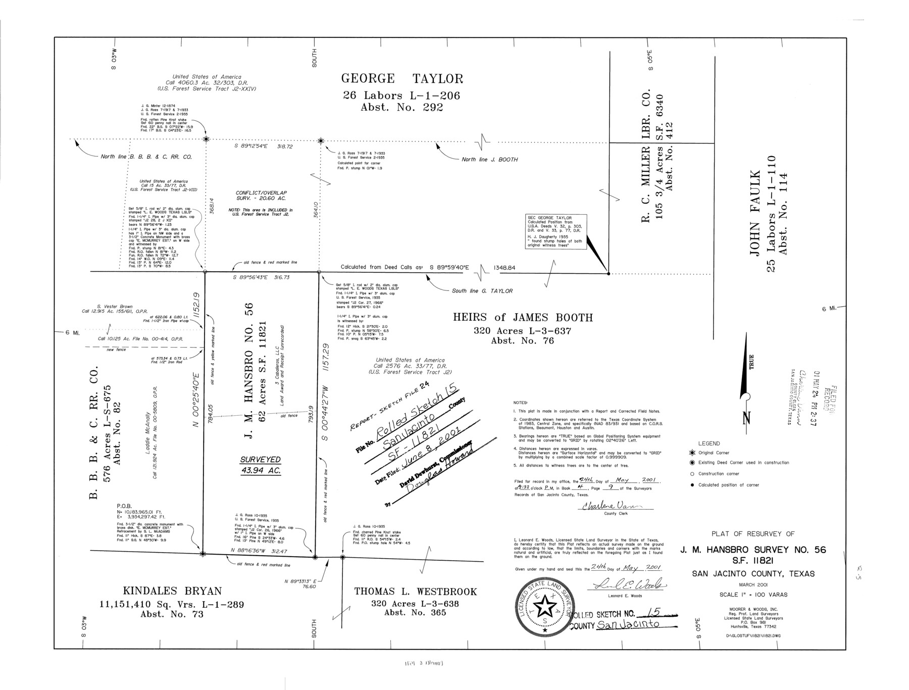
San Jacinto County Rolled Sketch 15
Plat of resurvey of J.M. Hansbro survey no. 56, SF-11821, San Jacinto County, Texas
-
Map/Doc
7571
-
Collection
General Map Collection
-
Object Dates
2001/5/24 (Creation Date)
2001/6/8 (File Date)
-
People and Organizations
Leonard E. Woods (Surveyor/Engineer)
-
Counties
San Jacinto
-
Subjects
Surveying Rolled Sketch
-
Height x Width
19.2 x 25.2 inches
48.8 x 64.0 cm
-
Medium
mylar, print
-
Scale
1" = 100 varas
-
Comments
See San Jacinto County Sketch File 24 (35816) for report.
Related maps
San Jacinto County Sketch File 24

Print $18.00
San Jacinto County Sketch File 24
2001
Size 14.5 x 8.9 inches
Map/Doc 35816
Part of: General Map Collection
Hudspeth County Rolled Sketch 43

Print $40.00
- Digital $50.00
Hudspeth County Rolled Sketch 43
1932
Size 155.2 x 14.6 inches
Map/Doc 9216
Copy of Surveyor's Field Book, Morris Browning - In Blocks 7, 5 & 4, I&GNRRCo., Hutchinson and Carson Counties, Texas

Print $2.00
- Digital $50.00
Copy of Surveyor's Field Book, Morris Browning - In Blocks 7, 5 & 4, I&GNRRCo., Hutchinson and Carson Counties, Texas
1888
Size 8.9 x 7.1 inches
Map/Doc 62287
Gillespie County

Print $20.00
- Digital $50.00
Gillespie County
1945
Size 36.7 x 45.6 inches
Map/Doc 77289
Texas Coast, No. 17

Print $20.00
- Digital $50.00
Texas Coast, No. 17
Size 18.3 x 26.1 inches
Map/Doc 72713
Zavala County Sketch File 49

Print $10.00
- Digital $50.00
Zavala County Sketch File 49
1955
Size 14.5 x 9.1 inches
Map/Doc 41441
Orange County Rolled Sketch 29

Print $20.00
- Digital $50.00
Orange County Rolled Sketch 29
1960
Size 25.9 x 37.2 inches
Map/Doc 7187
Nueces County Aerial Photograph Index Sheet 5

Print $20.00
- Digital $50.00
Nueces County Aerial Photograph Index Sheet 5
1956
Size 19.5 x 23.4 inches
Map/Doc 83738
State Prison System, Cherokee County

Print $20.00
- Digital $50.00
State Prison System, Cherokee County
Size 17.9 x 13.8 inches
Map/Doc 73561
Foard County Sketch File 8

Print $6.00
- Digital $50.00
Foard County Sketch File 8
Size 10.5 x 11.8 inches
Map/Doc 22810
Frio County Sketch File 19

Print $20.00
- Digital $50.00
Frio County Sketch File 19
1963
Size 14.7 x 30.6 inches
Map/Doc 11519
Liberty County Rolled Sketch 15

Print $20.00
- Digital $50.00
Liberty County Rolled Sketch 15
2015
Size 36.2 x 24.5 inches
Map/Doc 94024
Bastrop County Sketch File 8

Print $4.00
- Digital $50.00
Bastrop County Sketch File 8
Size 8.5 x 11.5 inches
Map/Doc 14054
You may also like
Nueces County Sketch File 42

Print $24.00
- Digital $50.00
Nueces County Sketch File 42
1950
Size 11.0 x 8.6 inches
Map/Doc 32633
Flight Mission No. BRE-2P, Frame 65, Nueces County

Print $20.00
- Digital $50.00
Flight Mission No. BRE-2P, Frame 65, Nueces County
1956
Size 18.4 x 22.3 inches
Map/Doc 86760
Tarrant County Rolled Sketch 4

Print $20.00
- Digital $50.00
Tarrant County Rolled Sketch 4
Size 27.0 x 18.9 inches
Map/Doc 7911
Knox County Working Sketch 9

Print $20.00
- Digital $50.00
Knox County Working Sketch 9
1945
Size 33.8 x 43.3 inches
Map/Doc 70251
Palo Pinto County Sketch File B

Print $20.00
- Digital $50.00
Palo Pinto County Sketch File B
Size 45.3 x 45.5 inches
Map/Doc 10566
Hood County Working Sketch 11

Print $20.00
- Digital $50.00
Hood County Working Sketch 11
1976
Size 19.7 x 25.2 inches
Map/Doc 66205
Flight Mission No. DQO-3K, Frame 28, Galveston County

Print $20.00
- Digital $50.00
Flight Mission No. DQO-3K, Frame 28, Galveston County
1952
Size 18.1 x 22.3 inches
Map/Doc 85069
Castro County Sketch File 15

Print $4.00
- Digital $50.00
Castro County Sketch File 15
1978
Size 11.2 x 8.7 inches
Map/Doc 17511
United States - Gulf Coast - From Latitude 26° 33' to the Rio Grande Texas

Print $20.00
- Digital $50.00
United States - Gulf Coast - From Latitude 26° 33' to the Rio Grande Texas
1916
Size 27.8 x 18.3 inches
Map/Doc 72837
No. 3 Chart of Channel connecting Corpus Christi Bay with Aransas Bay, Texas

Print $20.00
- Digital $50.00
No. 3 Chart of Channel connecting Corpus Christi Bay with Aransas Bay, Texas
1878
Size 18.2 x 28.0 inches
Map/Doc 72772
Falls County Sketch File 32

Print $20.00
- Digital $50.00
Falls County Sketch File 32
Size 36.3 x 24.7 inches
Map/Doc 11468
Bell County Working Sketch 8

Print $20.00
- Digital $50.00
Bell County Working Sketch 8
1954
Size 44.2 x 37.3 inches
Map/Doc 67348