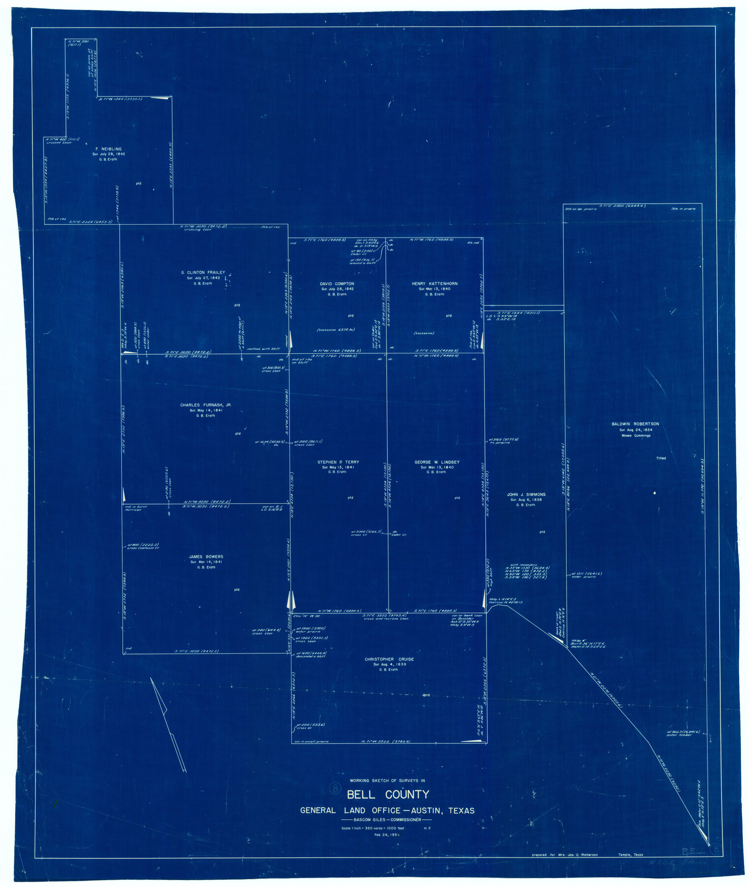
Bell County Working Sketch 8
-
Map/Doc
67348
-
Collection
General Map Collection
-
Object Dates
2/24/1954 (Creation Date)
-
People and Organizations
Bascom Giles (GLO Commissioner)
Herman Forbes (Draftsman)
-
Counties
Bell
-
Subjects
Surveying Working Sketch
-
Height x Width
44.2 x 37.3 inches
112.3 x 94.7 cm
-
Scale
1" = 360 varas
-
Comments
Surveys located about three miles North 20 degrees East of Belton, Texas.
Part of: General Map Collection
Collin County Working Sketch 3

Print $20.00
- Digital $50.00
Collin County Working Sketch 3
1935
Size 25.8 x 41.7 inches
Map/Doc 68097
Karte des Staates Texas (aufgenommen in die Union 1846) nach der neuesten Eintheilung

Print $20.00
- Digital $50.00
Karte des Staates Texas (aufgenommen in die Union 1846) nach der neuesten Eintheilung
1849
Size 13.6 x 16.6 inches
Map/Doc 90066
Coast Chart No. 212 - From Latitude 26° 33' to the Rio Grande, Texas

Print $20.00
- Digital $50.00
Coast Chart No. 212 - From Latitude 26° 33' to the Rio Grande, Texas
1886
Size 21.9 x 17.5 inches
Map/Doc 73505
Coke County Working Sketch 17

Print $20.00
- Digital $50.00
Coke County Working Sketch 17
1948
Size 18.2 x 19.4 inches
Map/Doc 68054
Flight Mission No. DJV-3P, Frame 15, Ellis County

Print $20.00
- Digital $50.00
Flight Mission No. DJV-3P, Frame 15, Ellis County
1956
Size 18.8 x 22.4 inches
Map/Doc 84977
Liberty County Sketch File 54

Print $54.00
- Digital $50.00
Liberty County Sketch File 54
1889
Size 14.3 x 8.7 inches
Map/Doc 30022
Parker County Sketch File 6

Print $6.00
- Digital $50.00
Parker County Sketch File 6
1858
Size 6.9 x 6.0 inches
Map/Doc 33530
Flight Mission No. BRA-16M, Frame 129, Jefferson County

Print $20.00
- Digital $50.00
Flight Mission No. BRA-16M, Frame 129, Jefferson County
1953
Size 18.4 x 22.7 inches
Map/Doc 85739
McCulloch County Working Sketch 8

Print $20.00
- Digital $50.00
McCulloch County Working Sketch 8
1977
Size 22.5 x 19.8 inches
Map/Doc 70683
Hidalgo County Sketch File 10

Print $20.00
- Digital $50.00
Hidalgo County Sketch File 10
1911
Size 16.3 x 34.8 inches
Map/Doc 11762
Wilson County Sketch File 3b

Print $22.00
- Digital $50.00
Wilson County Sketch File 3b
Size 7.8 x 11.9 inches
Map/Doc 40402
Rio Grande Rectification Project, El Paso and Juarez Valley

Print $20.00
- Digital $50.00
Rio Grande Rectification Project, El Paso and Juarez Valley
1935
Size 11.0 x 29.7 inches
Map/Doc 60864
You may also like
[Map of Portion of Pecos County as Surveyed by F. F. Friend]
![91562, [Map of Portion of Pecos County as Surveyed by F. F. Friend], Twichell Survey Records](https://historictexasmaps.com/wmedia_w700/maps/91562-1.tif.jpg)
Print $3.00
- Digital $50.00
[Map of Portion of Pecos County as Surveyed by F. F. Friend]
1926
Size 17.0 x 11.4 inches
Map/Doc 91562
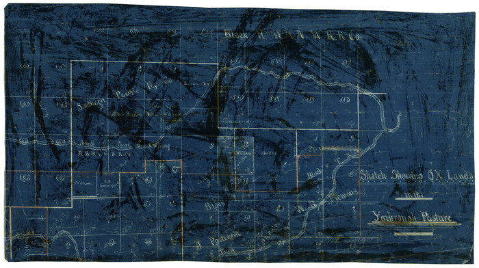
Sketch showing OX lands in the Yarbrough Pasture
Print $20.00
- Digital $50.00
Sketch showing OX lands in the Yarbrough Pasture
Size 14.0 x 25.2 inches
Map/Doc 4433
Goliad County Working Sketch 13

Print $20.00
- Digital $50.00
Goliad County Working Sketch 13
1943
Size 28.3 x 40.8 inches
Map/Doc 63203
Angelina County Rolled Sketch 5

Print $40.00
- Digital $50.00
Angelina County Rolled Sketch 5
1993
Size 36.0 x 75.3 inches
Map/Doc 9328
Map of Dickens County

Print $20.00
- Digital $50.00
Map of Dickens County
1899
Size 41.1 x 37.7 inches
Map/Doc 4933
Frio County Rolled Sketch 23

Print $20.00
- Digital $50.00
Frio County Rolled Sketch 23
1962
Size 39.4 x 40.8 inches
Map/Doc 8912
Flight Mission No. DIX-3P, Frame 164, Aransas County

Print $20.00
- Digital $50.00
Flight Mission No. DIX-3P, Frame 164, Aransas County
1956
Size 17.8 x 18.0 inches
Map/Doc 83770
[Sections 69-84 Block 47 and part of Block 3]
![91795, [Sections 69-84 Block 47 and part of Block 3], Twichell Survey Records](https://historictexasmaps.com/wmedia_w700/maps/91795-1.tif.jpg)
Print $2.00
- Digital $50.00
[Sections 69-84 Block 47 and part of Block 3]
Size 14.3 x 8.9 inches
Map/Doc 91795
San Jacinto County Working Sketch 7

Print $20.00
- Digital $50.00
San Jacinto County Working Sketch 7
1935
Size 32.0 x 41.4 inches
Map/Doc 63720
Medina County Working Sketch 30

Print $20.00
- Digital $50.00
Medina County Working Sketch 30
1992
Size 19.2 x 15.4 inches
Map/Doc 70945
Hartley County Boundary File 5

Print $6.00
- Digital $50.00
Hartley County Boundary File 5
Size 12.7 x 8.2 inches
Map/Doc 54515
Flight Mission No. DAG-16K, Frame 68, Matagorda County

Print $20.00
- Digital $50.00
Flight Mission No. DAG-16K, Frame 68, Matagorda County
1952
Size 18.5 x 22.3 inches
Map/Doc 86314