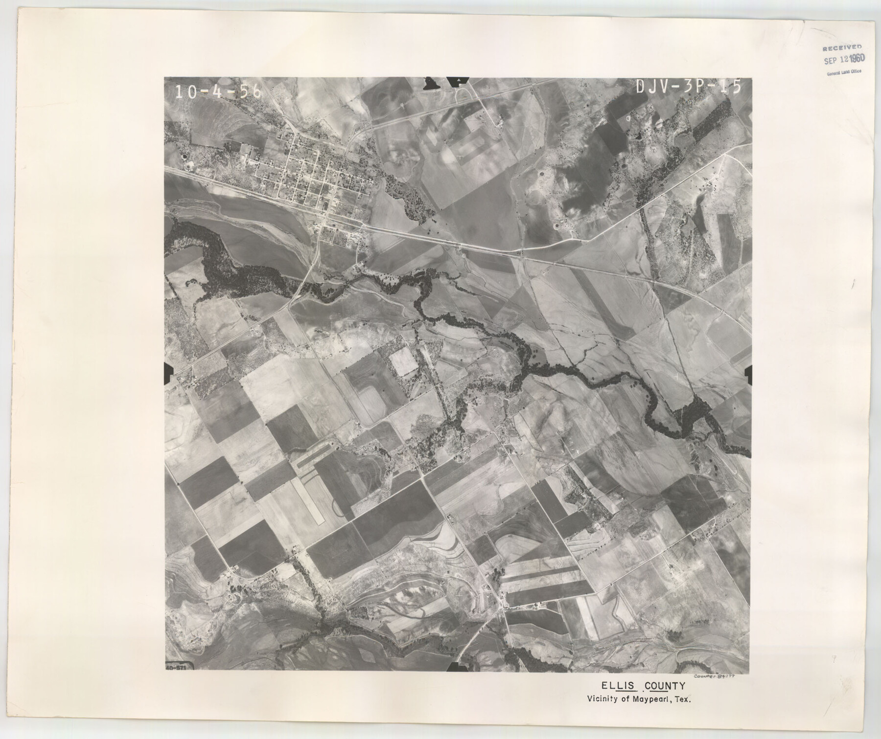
Flight Mission No. DJV-3P, Frame 15, Ellis County
DJV-3P-15
-
Map/Doc
84977
-
Collection
General Map Collection
-
Object Dates
1956/10/4 (Creation Date)
-
People and Organizations
U. S. Department of Agriculture (Publisher)
-
Counties
Ellis
-
Subjects
Aerial Photograph
-
Height x Width
18.8 x 22.4 inches
47.8 x 56.9 cm
-
Comments
Flown in the vicinity of Maypearl, Texas.
Received in office September 12, 1960.
Part of: General Map Collection
Grayson County Working Sketch 7

Print $20.00
- Digital $50.00
Grayson County Working Sketch 7
1940
Size 41.1 x 27.7 inches
Map/Doc 63246
Roberts County Rolled Sketch 3

Print $40.00
- Digital $50.00
Roberts County Rolled Sketch 3
Size 38.0 x 49.7 inches
Map/Doc 8354
Flight Mission No. DIX-3P, Frame 172, Aransas County

Print $20.00
- Digital $50.00
Flight Mission No. DIX-3P, Frame 172, Aransas County
1956
Size 17.7 x 18.3 inches
Map/Doc 83778
County Map of Texas and Indian Territory

Print $20.00
- Digital $50.00
County Map of Texas and Indian Territory
1881
Size 13.1 x 9.9 inches
Map/Doc 94153
Real County Sketch File 5

Print $20.00
- Digital $50.00
Real County Sketch File 5
Size 16.9 x 20.9 inches
Map/Doc 12228
Nacogdoches County Sketch File 11

Print $2.00
- Digital $50.00
Nacogdoches County Sketch File 11
Size 8.0 x 8.8 inches
Map/Doc 32255
Comanche County Sketch File 19

Print $12.00
- Digital $50.00
Comanche County Sketch File 19
Size 13.0 x 8.0 inches
Map/Doc 19093
Cameron County Rolled Sketch 20B

Print $20.00
- Digital $50.00
Cameron County Rolled Sketch 20B
1960
Size 25.2 x 13.5 inches
Map/Doc 5472
Colton's New Map of the State of Texas Compiled from J. De Cordova's large Map

Print $20.00
- Digital $50.00
Colton's New Map of the State of Texas Compiled from J. De Cordova's large Map
1859
Size 17.9 x 28.3 inches
Map/Doc 90094
Harbor Pass and Bar at Brazos Santiago, Texas

Print $20.00
- Digital $50.00
Harbor Pass and Bar at Brazos Santiago, Texas
1879
Size 18.2 x 27.5 inches
Map/Doc 73000
Gulf Coast of the United States, Key West to Rio Grande

Print $20.00
- Digital $50.00
Gulf Coast of the United States, Key West to Rio Grande
1863
Size 27.3 x 18.2 inches
Map/Doc 72663
Topographical Map of the Rio Grande, Sheet No. 4

Print $20.00
- Digital $50.00
Topographical Map of the Rio Grande, Sheet No. 4
1912
Map/Doc 89528
You may also like
Gonzales County

Print $20.00
- Digital $50.00
Gonzales County
1871
Size 17.2 x 25.8 inches
Map/Doc 3593
Sabine Bank to East Bay including Heald Bank

Print $20.00
- Digital $50.00
Sabine Bank to East Bay including Heald Bank
1971
Size 45.0 x 34.4 inches
Map/Doc 69849
Pecos County Rolled Sketch 160

Print $20.00
- Digital $50.00
Pecos County Rolled Sketch 160
Size 43.0 x 36.9 inches
Map/Doc 9739
[Texas & Pacific Railway through Callahan County]
![64231, [Texas & Pacific Railway through Callahan County], General Map Collection](https://historictexasmaps.com/wmedia_w700/maps/64231.tif.jpg)
Print $20.00
- Digital $50.00
[Texas & Pacific Railway through Callahan County]
1918
Size 21.2 x 9.5 inches
Map/Doc 64231
Comanche County Sketch File 16a

Print $4.00
- Digital $50.00
Comanche County Sketch File 16a
Size 6.1 x 8.5 inches
Map/Doc 19084
Hudspeth County Rolled Sketch 64

Print $40.00
- Digital $50.00
Hudspeth County Rolled Sketch 64
1986
Size 39.1 x 81.9 inches
Map/Doc 9228
Kent County Working Sketch 3b

Print $20.00
- Digital $50.00
Kent County Working Sketch 3b
1948
Size 24.9 x 23.3 inches
Map/Doc 70010
[Sketch for Mineral Application 15559 - Hutchinson County, Canadian River]
![65680, [Sketch for Mineral Application 15559 - Hutchinson County, Canadian River], General Map Collection](https://historictexasmaps.com/wmedia_w700/maps/65680-1.tif.jpg)
Print $20.00
- Digital $50.00
[Sketch for Mineral Application 15559 - Hutchinson County, Canadian River]
1926
Size 12.0 x 13.2 inches
Map/Doc 65680
A Pocket Guide to Austin, Texas - Area Map and Downtown Map

A Pocket Guide to Austin, Texas - Area Map and Downtown Map
Size 17.2 x 20.2 inches
Map/Doc 94386
El Paso County Rolled Sketch 66

Print $20.00
- Digital $50.00
El Paso County Rolled Sketch 66
2014
Size 35.1 x 41.2 inches
Map/Doc 93712
Nueces County Rolled Sketch 85

Print $72.00
Nueces County Rolled Sketch 85
1982
Size 18.5 x 24.9 inches
Map/Doc 6971
Liberty County Rolled Sketch WC

Print $107.00
- Digital $50.00
Liberty County Rolled Sketch WC
1934
Size 10.4 x 15.3 inches
Map/Doc 46561