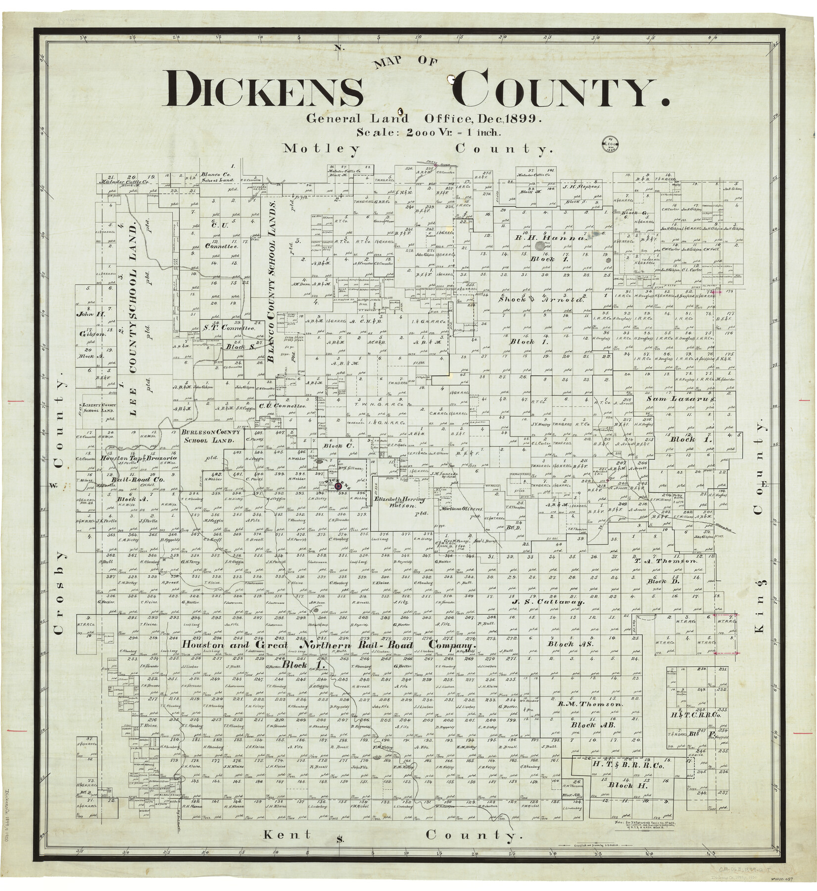
Map of Dickens County
-
Map/Doc
4933
-
Collection
General Map Collection
-
Object Dates
1899 (Creation Date)
-
People and Organizations
Texas General Land Office (Publisher)
John D. Hedick (Draftsman)
John D. Hedick (Compiler)
-
Counties
Dickens
-
Subjects
County
-
Height x Width
41.1 x 37.7 inches
104.4 x 95.8 cm
-
Comments
Traced in November 1900 by Legg.
Part of: General Map Collection
Map of Cameron, Hidalgo and half of Starr County of Texas

Print $20.00
- Digital $50.00
Map of Cameron, Hidalgo and half of Starr County of Texas
1942
Size 42.1 x 29.6 inches
Map/Doc 60401
Bee County Working Sketch 23

Print $20.00
- Digital $50.00
Bee County Working Sketch 23
1985
Size 32.6 x 31.1 inches
Map/Doc 67273
Pecos County Rolled Sketch 126

Print $20.00
- Digital $50.00
Pecos County Rolled Sketch 126
1948
Size 42.5 x 38.4 inches
Map/Doc 9724
Reagan County Sketch File 19

Print $26.00
- Digital $50.00
Reagan County Sketch File 19
1937
Size 14.0 x 28.7 inches
Map/Doc 12220
Dimmit County Sketch File 58

Print $20.00
- Digital $50.00
Dimmit County Sketch File 58
1951
Size 18.0 x 9.8 inches
Map/Doc 11361
Harris County Working Sketch 123

Print $20.00
- Digital $50.00
Harris County Working Sketch 123
1993
Size 19.5 x 17.0 inches
Map/Doc 66015
[San Patricio No. 2]
![69746, [San Patricio No. 2], General Map Collection](https://historictexasmaps.com/wmedia_w700/maps/69746.tif.jpg)
Print $2.00
- Digital $50.00
[San Patricio No. 2]
1847
Size 8.3 x 11.2 inches
Map/Doc 69746
Presidio County Working Sketch 62

Print $3.00
- Digital $50.00
Presidio County Working Sketch 62
1958
Size 12.6 x 9.5 inches
Map/Doc 71739
Childress County Sketch File 16b

Print $6.00
- Digital $50.00
Childress County Sketch File 16b
1884
Size 12.6 x 8.1 inches
Map/Doc 18305
Brewster County Rolled Sketch 106

Print $20.00
- Digital $50.00
Brewster County Rolled Sketch 106
1958
Size 20.7 x 24.6 inches
Map/Doc 5258
McMullen County Working Sketch 8

Print $20.00
- Digital $50.00
McMullen County Working Sketch 8
1936
Size 27.2 x 33.0 inches
Map/Doc 70709
Shelby County Sketch File 22

Print $6.00
- Digital $50.00
Shelby County Sketch File 22
Size 15.4 x 10.2 inches
Map/Doc 36643
You may also like
Sketch No. 2 [showing Block 46, Block M21, Block B4 and Block Y south of Canadian River]
![89929, Sketch No. 2 [showing Block 46, Block M21, Block B4 and Block Y south of Canadian River], Twichell Survey Records](https://historictexasmaps.com/wmedia_w700/maps/89929-1.tif.jpg)
Print $20.00
- Digital $50.00
Sketch No. 2 [showing Block 46, Block M21, Block B4 and Block Y south of Canadian River]
1927
Size 36.8 x 43.7 inches
Map/Doc 89929
Flight Mission No. DQN-1K, Frame 83, Calhoun County

Print $20.00
- Digital $50.00
Flight Mission No. DQN-1K, Frame 83, Calhoun County
1953
Size 18.4 x 22.2 inches
Map/Doc 84168
Montgomery County Rolled Sketch 44

Print $20.00
- Digital $50.00
Montgomery County Rolled Sketch 44
2004
Size 24.5 x 18.1 inches
Map/Doc 82451
Childress County Working Sketch 3

Print $20.00
- Digital $50.00
Childress County Working Sketch 3
1927
Size 22.4 x 18.6 inches
Map/Doc 68019
Baylor County Boundary File 17

Print $20.00
- Digital $50.00
Baylor County Boundary File 17
Size 20.0 x 7.7 inches
Map/Doc 50434
Motley County Working Sketch 2

Print $20.00
- Digital $50.00
Motley County Working Sketch 2
1895
Size 17.3 x 21.3 inches
Map/Doc 71207
Jim Hogg County Sketch File 6

Print $20.00
- Digital $50.00
Jim Hogg County Sketch File 6
1939
Size 17.9 x 19.6 inches
Map/Doc 11886
Working Sketch in Matagorda County

Print $20.00
- Digital $50.00
Working Sketch in Matagorda County
1890
Size 36.6 x 22.7 inches
Map/Doc 4479
[Map of Counties south of Panhandle]
![92960, [Map of Counties south of Panhandle], Twichell Survey Records](https://historictexasmaps.com/wmedia_w700/maps/92960-1.tif.jpg)
Print $20.00
- Digital $50.00
[Map of Counties south of Panhandle]
Size 22.1 x 15.8 inches
Map/Doc 92960
Kenedy County Rolled Sketch 3

Print $40.00
- Digital $50.00
Kenedy County Rolled Sketch 3
1904
Size 40.1 x 57.4 inches
Map/Doc 9329

[I. & G. N. Block 1]
![93028, [I. & G. N. Block 1], Twichell Survey Records](https://historictexasmaps.com/wmedia_w700/maps/93028-1.tif.jpg)
Print $20.00
- Digital $50.00
[I. & G. N. Block 1]
Size 42.3 x 32.8 inches
Map/Doc 93028